
Fitxategi:Jfader dryden.jpg

Aurreikuspen honen neurria: 800 × 593 pixel. Bestelako bereizmenak: 320 × 237 pixel | 640 × 474 pixel | 1.024 × 758 pixel | 1.280 × 948 pixel.
Bereizmen handikoa ((1.280 × 948 pixel, fitxategiaren tamaina: 1,04 MB, MIME mota: image/jpeg))
Fitxategi hau Wikimedia Commonsekoa da. Hango deskribapen orriko informazioa behean duzu. |
|
Laburpena
| Deskribapena |
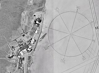
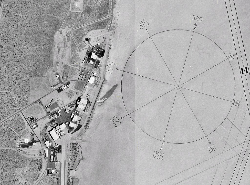
English: NASA 1m satellite photo (composite) of Dryden Research Center on Edwards Air Force Base, California. |
| Data | 2005ko maiatzaren 4a (igoera data) |
| Jatorria | Screenshot from NASA World Wind software |
| Egilea | NASA |
| Beste bertsioak | File:Dryden AFB Compass Rose.jpg (version without yellow pixels) |
| Kameraren kokapena | | Irudi hau eta gehiago beraien kokapenekin hurrengo lekuetan: OpenStreetMap |
|---|
Lizentzia
| This image is in the public domain because it is a screenshot from NASA’s globe software World Wind using a public domain layer, such as Blue Marble, MODIS, Landsat, SRTM, USGS or GLOBE.
|
 |
Fitxategiaren historia
Data/orduan klik egin fitxategiak orduan zuen itxura ikusteko.
| Data/Ordua | Iruditxoa | Neurriak | Erabiltzailea | Iruzkina | |
|---|---|---|---|---|---|
| oraingoa | 15:27, 4 maiatza 2005 | | 1.280 × 948 (1,04 MB) | John Fader~commonswiki | NASA 1m satellite photo (montage) of Dryden Research Center near Edwards, California. Made using w:en:NASA World Wind {{PD-USGov-NASA}} |
Irudira dakarten loturak
Hurrengo orrialdeek dute fitxategi honetarako lotura:
Fitxategiaren erabilera orokorra
Hurrengo beste wikiek fitxategi hau darabilte:
- ar.wikipedia.org proiektuan duen erabilera
- de.wikipedia.org proiektuan duen erabilera
- en.wikipedia.org proiektuan duen erabilera
- Edwards Air Force Base
- Armstrong Flight Research Center
- Portal talk:Aviation/Selected picture
- Portal:Earth sciences
- Portal:North America/Selected picture
- Wikipedia:Featured pictures thumbs/06
- Rogers Dry Lake
- Wikipedia:Featured pictures/Space/Looking back
- Wikipedia:Featured picture candidates/March-2007
- Wikipedia:Featured picture candidates/Jfader dryden.jpg
- Wikipedia:WikiProject Aviation/Featured and good content
- Wikipedia:Wikipedia Signpost/2007-04-02/Features and admins
- Wikipedia:Wikipedia Signpost/2007-04-02/SPV
- List of National Historic Landmarks in California
- Wikipedia:Picture of the day/July 2007
- Template:POTD/2007-07-24
- Portal:Earth sciences/Selected pictures
- Portal:National Register of Historic Places/Portal picture
- Portal:North America/Selected picture/26
- Portal:National Register of Historic Places/Portal picture/21
- Wikipedia:WikiProject Spaceflight/Recognized content
- Wikipedia:WikiProject Spaceflight/Downlink/RCWatchlist
- User:JKBodylski/sandbox
- Portal:Geography/Selected picture
- Wikipedia:Wikipedia Signpost/Single/2007-04-02
- en.wikivoyage.org proiektuan duen erabilera
- es.wikipedia.org proiektuan duen erabilera
- fa.wikipedia.org proiektuan duen erabilera
- fr.wikipedia.org proiektuan duen erabilera
- he.wikipedia.org proiektuan duen erabilera
- it.wikipedia.org proiektuan duen erabilera
- ja.wikipedia.org proiektuan duen erabilera
- ko.wikipedia.org proiektuan duen erabilera
- ms.wikipedia.org proiektuan duen erabilera
- nl.wikipedia.org proiektuan duen erabilera
- no.wikipedia.org proiektuan duen erabilera
- pl.wikipedia.org proiektuan duen erabilera
- ps.wikipedia.org proiektuan duen erabilera
- pt.wikipedia.org proiektuan duen erabilera
Ikus fitxategi honen erabilpen global gehiago.