
Fitxategi:Karoo ecoregion.jpg
Ez dago bereizmen handiagorik.
Karoo_ecoregion.jpg ((644 × 496 pixel, fitxategiaren tamaina: 114 KB, MIME mota: image/jpeg))
Fitxategi hau Wikimedia Commonsekoa da. Hango deskribapen orriko informazioa behean duzu. |
Laburpena
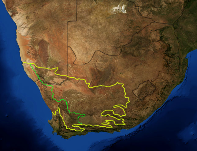
| Deskribapena | This is a map showing the location of the two Karoo ecoregions of southern Africa, as delineated by the World Wide Fund for Nature. The yellow line encloses the two ecoregions. The green line separates the Succulent Karoo, on the west, from the Nama Karoo, on the east. National boundaries are shown in black. I, Pfly, made it using NASA Blue Marble imagery and ecoregion GIS data which I simplified and digitized in Photoshop. |
| Data | |
| Jatorria | NASA, plus my additions by myself. |
| Egilea | Pfly |
Lizentzia
| This file is in the public domain in the United States because it was solely created by NASA. NASA copyright policy states that "NASA material is not protected by copyright unless noted". (See Template:PD-USGov, NASA copyright policy page or JPL Image Use Policy.) | ||
 |
Warnings:
|
Fitxategiaren historia
Data/orduan klik egin fitxategiak orduan zuen itxura ikusteko.
| Data/Ordua | Iruditxoa | Neurriak | Erabiltzailea | Iruzkina | |
|---|---|---|---|---|---|
| oraingoa | 22:29, 19 urtarrila 2007 | | 644 × 496 (114 KB) | Pfly | {{Information |Description=This is a map showing the location of the two Karoo ecoregions of southern Africa, as delineated by the World Wide Fund for Nature. The yellow line encloses the two ecoregions. Th |
Irudira dakarten loturak
Ez dago fitxategi hau darabilen orririk.
Fitxategiaren erabilera orokorra
Hurrengo beste wikiek fitxategi hau darabilte:
- af.wikipedia.org proiektuan duen erabilera
- bg.wikipedia.org proiektuan duen erabilera
- ca.wikipedia.org proiektuan duen erabilera
- de.wikipedia.org proiektuan duen erabilera
- en.wikipedia.org proiektuan duen erabilera
- eo.wikipedia.org proiektuan duen erabilera
- es.wikipedia.org proiektuan duen erabilera
- fi.wikipedia.org proiektuan duen erabilera
- frr.wikipedia.org proiektuan duen erabilera
- fr.wikipedia.org proiektuan duen erabilera
- fr.wiktionary.org proiektuan duen erabilera
- gl.wikipedia.org proiektuan duen erabilera
- hu.wikipedia.org proiektuan duen erabilera
- it.wikipedia.org proiektuan duen erabilera
- ja.wikipedia.org proiektuan duen erabilera
- ka.wikipedia.org proiektuan duen erabilera
- ko.wikipedia.org proiektuan duen erabilera
- lt.wikipedia.org proiektuan duen erabilera
- nl.wikipedia.org proiektuan duen erabilera
- no.wikipedia.org proiektuan duen erabilera
- pt.wikipedia.org proiektuan duen erabilera
- ru.wikipedia.org proiektuan duen erabilera
- sv.wikipedia.org proiektuan duen erabilera
- sw.wikipedia.org proiektuan duen erabilera
- tr.wikipedia.org proiektuan duen erabilera