
Fitxategi:Kingdom of Bavaria 1815.svg

SVG fitxategi honen PNG aurreikuspenaren tamaina: 450 × 456 pixel. Bestelako bereizmenak: 237 × 240 pixel | 474 × 480 pixel | 758 × 768 pixel | 1.011 × 1.024 pixel | 2.021 × 2.048 pixel.
Bereizmen handikoa (SVG fitxategia, nominaldi 450 × 456 pixel, fitxategiaren tamaina: 812 KB)
Fitxategi hau Wikimedia Commonsekoa da. Hango deskribapen orriko informazioa behean duzu. |
Laburpena


.svg)
.svg)
.svg)
.svg)
.svg)


.svg)
.svg)
.svg)


.png)
.png)


.svg)


.svg)

.svg)


.svg)
.svg)
.svg)
.svg)


.svg)
.png)


.svg)


.svg)
.svg)


.svg)


.svg)


.svg)
.svg)
.svg)
.svg)
.svg)
.svg)
.svg)
_cropped.svg)
.svg)
.svg)
.svg)
.svg)
.svg)
.svg)
.svg)
.svg)
.svg)
.svg)
.svg)
.svg)
.svg)
.svg)
.svg)
.svg)
.svg)
.svg)
.svg)
.svg)
.svg)
.svg)
.svg)
.svg)
.svg)
.svg)
.svg)
.svg)
.svg)
.svg)
.svg)
.svg)
.svg)
.svg)
.svg)
.svg)
.svg)
.svg)
.svg)
.svg)
.svg)
.svg)
.svg)
.svg)
.svg)
Lizentzia
Fitxategi hau Creative Commons Attribution-Share Alike 3.0 Unported lizentziapean dago.
- Askea zara:
- partekatzeko – lana kopiatzeko, banatzeko eta bidaltzeko
- birnahasteko – lana moldatzeko
- Ondorengo baldintzen pean:
- eskuduntza – Egiletza behar bezala aitortu behar duzu, lizentzia ikusteko esteka gehitu, eta ea aldaketak egin diren aipatu. Era egokian egin behar duzu hori guztia, baina inola ere ez egileak zure lana edo zure erabilera babesten duela irudikatuz.
- berdin partekatu – Lan honetan oinarrituta edo aldatuta berria eraikitzen baduzu, emaitza lana hau bezalako lizentzia batekin argitaratu behar duzu.
Jatorrizko igoera erregistroa
This image is a derivative work of the following images:
- File:Blank_map_of_Europe.svg licensed with Cc-by-sa-2.5
- 2012-02-21T16:27:27Z Alphathon 680x520 (614699 Bytes) Updated Metadata and the boarders/coastlines along the western coast of the Black Sea
- 2011-09-19T22:57:58Z Alphathon 680x520 (603759 Bytes) Added North/Northern Cyprus
- 2011-08-23T10:26:48Z Heb 680x520 (604212 Bytes) Added [[:en:Bornholm]] (taken from [[:File:Denmark blank map.svg]])
- 2011-04-12T00:40:40Z Alphathon 680x520 (602549 Bytes) Upgraded Sicily based on "File:Freeworldmaps-sicily.jpg". Upgraded Malta based on "File:Map of Malta 2.png". Simplified Croatian borders.
- 2011-04-10T21:43:04Z Alphathon 680x520 (607359 Bytes) Upgraded Croatia, Bosnia & Herzegovina, Slovenia and surrounding countries based on data from "File:Kroatien - Politische Gliederung (Karte).png"
- 2011-04-10T20:05:09Z Alphathon 680x520 (568373 Bytes) Improved Serbia, Montenegro and surrounding countries using data from "File:Serbia Map.png". Fixed Serbia-Montenegro border. Added Kosovo (using dashed border, since it is not a universally recognised nation, and left the lan
- 2011-04-10T15:55:02Z Alphathon 680x520 (524980 Bytes) Tweaked Ukraine and surrounding countries based on data from "File:Up-map.png"
- 2011-04-10T04:02:09Z Alphathon 680x520 (511168 Bytes) Improved Greece, Albania, F.Y.R. Macedonia and Bulgaria based on "File:Greece topo.jpg"
- 2011-04-10T02:48:52Z Alphathon 680x520 (505569 Bytes) Tweaked Germany and surrounding countries based on info from "File:Germany_general_map.png"
- 2011-04-10T01:54:05Z Alphathon 680x520 (493733 Bytes) Converted all lakes back to separate layer. Added Finish lakes and tweaked Finland shape based on "File:Finland 1996 CIA map.jpg". Added Swiss lakes based on "File:Suisse cantons.svg". Tweaked Scotland and added Lochs.
- 2011-04-10T00:07:54Z Alphathon 680x520 (450120 Bytes) Improved England outline and added Isle of Wight based on "File:England Regions - Blank.svg". Improved Denmark based on "File:2 digit postcode danmark.png". Improved Sweden based on "File:Map of Sweden, CIA, 1996.jpg"
- 2011-04-08T15:53:07Z Alphathon 680x520 (438878 Bytes) Upgraded/fixed various parts of the map. Details: *Some minor fixes to Ireland and added some of the larger lakes based on [[:File:Ireland_trad_counties_named.svg]] *Pretty major fixes to Scotland (mainly the west coast and i
- 2008-09-17T09:50:25Z F7 680x520 (531491 Bytes)
- 2008-09-17T09:42:57Z F7 680x520 (2353 Bytes)
- 2008-05-26T19:04:07Z Collard 680x520 (531491 Bytes) uploading on behalf of [[User:Checkit]], direct complaints to him plox: 'Moved countries out of the "outlines" group, removed "outlines" style class, remove separate style information for Russia'
- 2008-04-30T01:38:52Z TimothyBourke 680x520 (531767 Bytes) Changed the country code of Serbia to RS per [http://en.wikipedia.org/wiki/Serbian_country_codes] and the file [http://www.iso.org/iso/iso3166_en_code_lists.txt].
- 2008-02-08T22:44:37Z CarolSpears 680x520 (531767 Bytes) validated
- 2007-07-10T11:47:59Z MrWeeble 680x520 (533112 Bytes) Updated to include British Crown Dependencies as seperate entities and regroup them as "British Islands", with some simplifications to the XML and CSS
- 2007-05-14T17:17:34Z Zirland 680x520 (540659 Bytes) serbia and montenegro
- 2007-03-30T20:40:49Z W!B: 680x520 (538830 Bytes) minor corr: update nl:Ijsselmeer, del fi:lakes (all small), add ru:lake Oneka (all ref maps.google), glued northern irland back to ie ;)
- 2007-02-05T18:44:32Z Maix 680x520 (538295 Bytes) cropped
- 2007-02-04T15:07:29Z Maix 680x520 (538310 Bytes) {{Information |Description=A blank Map of Europe in SVG format. Every country has an id which is its ISO-3116-1-ALPHA2 code in lower case for easy coloring. |Source=Image based on [[Image:Europe_countries.svg|]] by [[User:Ti
Uploaded with derivativeFX
Fitxategiaren historia
Data/orduan klik egin fitxategiak orduan zuen itxura ikusteko.
| Data/Ordua | Iruditxoa | Neurriak | Erabiltzailea | Iruzkina | |
|---|---|---|---|---|---|
| oraingoa | 22:10, 11 abuztua 2013 | | 450 × 456 (812 KB) | Alphathon | Fixed Liechtenstein colour |
| 06:03, 11 abuztua 2013 |  | 450 × 456 (812 KB) | Alphathon | Fixed an error near Königsberg | |
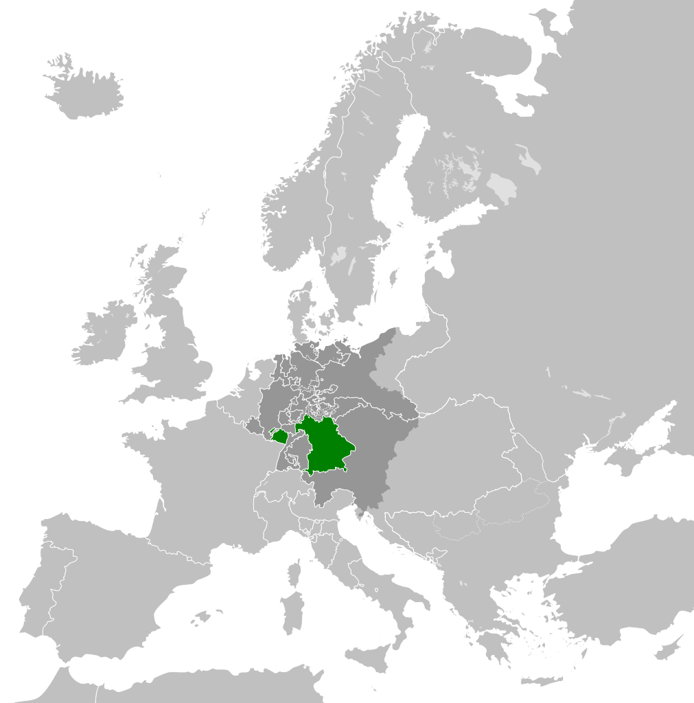
| 05:02, 11 abuztua 2013 |  | 450 × 456 (808 KB) | Alphathon | == {{int:filedesc}} == {{Information |Description={{en|Map of the en:Kingdom of Bavaria, circa 1815, following the en:Congress of Vienna. The en:German Confederation is shown in dark grey.}}{{de|Eine Landkarte des [[:de:Königreich Ba... |
Irudira dakarten loturak
Hurrengo orrialdeek dute fitxategi honetarako lotura:
Fitxategiaren erabilera orokorra
Hurrengo beste wikiek fitxategi hau darabilte:
- ar.wikipedia.org proiektuan duen erabilera
- ast.wikipedia.org proiektuan duen erabilera
- azb.wikipedia.org proiektuan duen erabilera
- az.wikipedia.org proiektuan duen erabilera
- bg.wikipedia.org proiektuan duen erabilera
- ca.wikipedia.org proiektuan duen erabilera
- cs.wikipedia.org proiektuan duen erabilera
- da.wikipedia.org proiektuan duen erabilera
- de.wikipedia.org proiektuan duen erabilera
- el.wikipedia.org proiektuan duen erabilera
- eo.wikipedia.org proiektuan duen erabilera
- es.wikipedia.org proiektuan duen erabilera
- fi.wikipedia.org proiektuan duen erabilera
- fr.wikipedia.org proiektuan duen erabilera
- gd.wikipedia.org proiektuan duen erabilera
- gl.wikipedia.org proiektuan duen erabilera
- he.wikipedia.org proiektuan duen erabilera
- hy.wikipedia.org proiektuan duen erabilera
- ltg.wikipedia.org proiektuan duen erabilera
- mk.wikipedia.org proiektuan duen erabilera
- mn.wikipedia.org proiektuan duen erabilera
- pt.wikipedia.org proiektuan duen erabilera
- rm.wikipedia.org proiektuan duen erabilera
- ro.wikipedia.org proiektuan duen erabilera
- simple.wikipedia.org proiektuan duen erabilera
- sr.wikipedia.org proiektuan duen erabilera
- sv.wikipedia.org proiektuan duen erabilera
- tr.wikipedia.org proiektuan duen erabilera
- vi.wikipedia.org proiektuan duen erabilera
- www.wikidata.org proiektuan duen erabilera