
Fitxategi:Kocaeli districts.png
Ez dago bereizmen handiagorik.
Kocaeli_districts.png ((776 × 600 pixel, fitxategiaren tamaina: 128 KB, MIME mota: image/png))
Fitxategi hau Wikimedia Commonsekoa da. Hango deskribapen orriko informazioa behean duzu. |
Laburpena
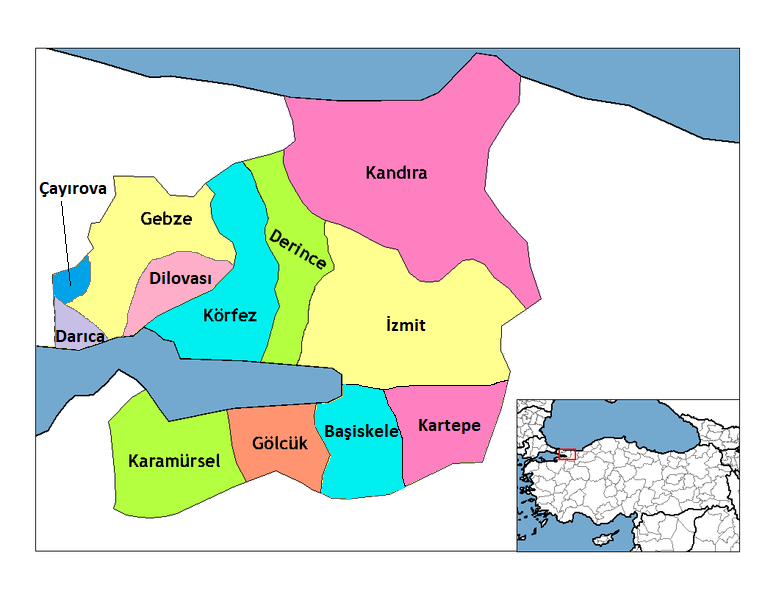
| Deskribapena | Map of the districts of Kocaeli province in Turkey. Created by Rarelibra 22:01, 1 December 2006 (UTC) for public domain use, using MapInfo Professional v8.5 and various mapping resources. Edited by One Homo Sapiens Corrected text where İ,Ş,ı,ğ,or ş occurs in name. Source: [statoids-com]. Increased font size and enhanced color differences among adjacent districts. |
| Data | 2006ko abenduaren 1ea (Jatorrizko igoera-data) |
| Jatorria | No machine-readable source provided. Own work assumed (based on copyright claims). |
| Egilea | No machine-readable author provided. Rarelibra assumed (based on copyright claims). |
Lizentzia
| Nik, lan honen egile eskubideen jabeak, lan hau domeinu publikoan jartzen dut. Mundu osoan du eragina honek. Estatu batzuetan beharbada hori ez da legez posible izango. Halakoetan: Edonori ematen diot lan hau edozertarako erabiltzeko eskubidea, inolako baldintzarik gabe, legeak nahitaez ezarritako baldintzak izan ezik. |
Fitxategiaren historia
Data/orduan klik egin fitxategiak orduan zuen itxura ikusteko.
| Data/Ordua | Iruditxoa | Neurriak | Erabiltzailea | Iruzkina | |
|---|---|---|---|---|---|
| oraingoa | 13:58, 11 abendua 2018 | | 776 × 600 (128 KB) | Surprizi | Updated/corrected map. |
| 22:25, 28 otsaila 2012 |  | 469 × 403 (38 KB) | Sadrettin | Reverted to version as of 09:02, 31 August 2009 | |
| 11:54, 26 otsaila 2012 |  | 776 × 600 (121 KB) | Nanahuatl | Reverted to version as of 13:17, 17 June 2009 | |
| 11:02, 31 abuztua 2009 |  | 469 × 403 (38 KB) | Krofesyonel | {{Information |Description=Kocaeli'nin doğru haritası, kendi çalışmamdır. |Source=Kendi çalışmam |Date=31 August 2009, Monday (''31 Ağustos 2009, Pazartesi'') |Author=User:Krofesyonel |Permission= |other_versions= }} | |
| 15:17, 17 ekaina 2009 |  | 776 × 600 (121 KB) | Argymeg | Reverted to version as of 19:23, 7 April 2009 | |
| 21:24, 7 apirila 2009 |  | 1.056 × 816 (26 KB) | Derinkaya | Reverted to version as of 01:23, 29 December 2008 | |
| 21:23, 7 apirila 2009 |  | 776 × 600 (121 KB) | Derinkaya | {{Information |Description=Map of the districts of Kocaeli province in Turkey. Created by Rarelibra 22:01, 1 December 2006 (UTC) for public domain use, using MapInfo Professional v8.5 and various mapping resources. Edited by [[User:One | |
| 03:23, 29 abendua 2008 |  | 1.056 × 816 (26 KB) | One Homo Sapiens | Corrected text where İ,Ş,ı,ğ,or ş occurs in name. Source: [statoids-com]. Increased font size and enhanced color differences among adjacent districts. | |
| 17:58, 12 apirila 2007 |  | 776 × 600 (96 KB) | KureCewlik81 | ||
| 16:15, 20 otsaila 2007 |  | 1.056 × 816 (27 KB) | Rarelibra | Updated/corrected map. |
Irudira dakarten loturak
Hurrengo orrialdeek dute fitxategi honetarako lotura:
Fitxategiaren erabilera orokorra
Hurrengo beste wikiek fitxategi hau darabilte:
- azb.wikipedia.org proiektuan duen erabilera
- az.wikipedia.org proiektuan duen erabilera
- ba.wikipedia.org proiektuan duen erabilera
- diq.wikipedia.org proiektuan duen erabilera
- en.wikipedia.org proiektuan duen erabilera
- en.wiktionary.org proiektuan duen erabilera
- eo.wikipedia.org proiektuan duen erabilera
- fa.wikipedia.org proiektuan duen erabilera
- fi.wikipedia.org proiektuan duen erabilera
- fo.wikipedia.org proiektuan duen erabilera
- fr.wikipedia.org proiektuan duen erabilera
- hy.wikipedia.org proiektuan duen erabilera
- id.wikipedia.org proiektuan duen erabilera
Ikus fitxategi honen erabilpen global gehiago.