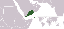
Fitxategi:LocationSouthYemen.png

Orriaren edukia ez da onartzen beste hizkuntza batzuetan.
Wikipedia, Entziklopedia askea

LocationSouthYemen.png((250 × 115 pixel, fitxategiaren tamaina: 6 KB, MIME mota: image/png))

Fitxategi hau Wikimedia Commonsekoa da. Hango deskribapen orriko informazioa behean duzu.
Commons gordailu bat da, lizentzia askea duten multimedia fitxategiena. Lagun dezakezu.

Fitxategi hau Wikimedia Commonsekoa da

Laburpena

English: Locator map of the People's Democratic Republic of Yemen (1967 - 1990).
  • A Soviet Socialist satellite nation in Arabia.
  • Formerly located in present day southern Yemen.
File:South Yemen in its region.svg fitxategi honen bektore bertsioa da. Hau rasterizatutako bertsioaren ordez erabili beharko litzateke hobea izatekotan.

File:LocationSouthYemen.png → File:South Yemen in its region.svg

Grafiko bektorialei buruzko informazioa lortzeko, irakurri SVGra trantsizioa Commonsen.
MediaWikiko SVG irudien inguruko laguntza teknikoa ere badago.

Beste hizkuntza batzuetan
Alemannisch  Bahasa Indonesia  Bahasa Melayu  British English  català  čeština  dansk  Deutsch  eesti  English  español  Esperanto  euskara  français  Frysk  galego  hrvatski  Ido  italiano  lietuvių  magyar  Nederlands  norsk bokmål  norsk nynorsk  occitan  Plattdüütsch  polski  português  português do Brasil  română  Scots  sicilianu  slovenčina  slovenščina  suomi  svenska  Tiếng Việt  Türkçe  vèneto  Ελληνικά  беларуская (тарашкевіца)  български  македонски  нохчийн  русский  српски / srpski  татарча/tatarça  українська  ქართული  հայերեն  বাংলা  தமிழ்  മലയാളം  ไทย  한국어  日本語  简体中文  繁體中文  עברית  العربية  فارسی  +/−
SVG irudi berria

This image was copied from wikipedia:en. The original description was:

Map showing South Yemen.

(Note: This map is old and therefore shows Eritrea as being part of Ethiopia)

GNU head Baimena duzu dokumentu hau kopiatu, banatu edo/eta aldatzeko GNU Free Documentation License baldintzapean, Free Software Foundationek argitaratutako 1.2 edo ondorengo bertsioan; sekzio aldaezinik gabe, azaleko testurik gabe, eta atzeko azaleko testurik gabe. Lizentziaren kopia dago GNU Free Documentation License izenburudun atalean.
w:eu:Creative Commons
eskuduntza berdin partekatu
Fitxategi hau Creative Commons Attribution-Share Alike 3.0 Unported lizentziapean dago.
Askea zara:
  • partekatzeko – lana kopiatzeko, banatzeko eta bidaltzeko
  • birnahasteko – lana moldatzeko
Ondorengo baldintzen pean:
  • eskuduntza – Egiletza behar bezala aitortu behar duzu, lizentzia ikusteko esteka gehitu, eta ea aldaketak egin diren aipatu. Era egokian egin behar duzu hori guztia, baina inola ere ez egileak zure lana edo zure erabilera babesten duela irudikatuz.
  • berdin partekatu – Lan honetan oinarrituta edo aldatuta berria eraikitzen baduzu, emaitza lana hau bezalako lizentzia batekin argitaratu behar duzu.
This licensing tag was added to this file as part of the GFDL licensing update.
date/time username edit summary
14:58, 27 December 2004 Quadell ({{GFDL}})
18:57, 26 May 2004 66.30.125.123
22:24, 24 February 2004 Morwen (map showing <a href="/wiki/South_Yemen" title="South Yemen">South Yemen</a>)

Irudi-oineko testuak

Add a one-line explanation of what this file represents

Fitxategi honetan agertzen diren itemak

honako hau irudikatzen du

Fitxategiaren historia

Data/orduan klik egin fitxategiak orduan zuen itxura ikusteko.

Data/OrduaIruditxoaNeurriakErabiltzaileaIruzkina
oraingoa20:56, 4 ekaina 200920:56, 4 ekaina 2009 bertsioaren iruditxoa250 × 115 (6 KB)HoshieFix the borders based on this map: http://www.lib.utexas.edu/maps/middle_east_and_asia/middle_east_pol_1976.jpg
13:08, 25 iraila 200713:08, 25 iraila 2007 bertsioaren iruditxoa250 × 115 (6 KB)Hoshiereadded the YAR/PDRY/Saudi Arabia boundary. The boundaries during this time in this region were (and in some cases, still are) disputed, undemarcated, or demarcated but undisclosed to the rest of the world.
09:37, 27 iraila 200609:37, 27 iraila 2006 bertsioaren iruditxoa250 × 115 (6 KB)HoshieI have corrected the boundry between the YAR and PDRY. The boundry then was unsettled. See this 1976 map: http://www.lib.utexas.edu/maps/middle_east_and_asia/middle_east_pol_1976.jpg Under same license as original.
00:02, 15 otsaila 200600:02, 15 otsaila 2006 bertsioaren iruditxoa250 × 115 (6 KB)Ingc~commonswikiLocation Map of Democratic Popoular Yemen. {{PD}} source:"http://en.wikipedia.org/wiki/Repubblica_Democratica_Popolare_dello_Yemen"
13:59, 11 urria 200513:59, 11 urria 2005 bertsioaren iruditxoa250 × 115 (6 KB)ChongDaeThis image was copied from wikipedia:en. The original description was: Map showing South Yemen.<br> <br> <i>(Note: This map is old and therefore shows Eritrea as being part of Ethiopia)</i> {{GFDL}} {| border="1" ! date/time || username || edit summ

Ez dago fitxategi hau darabilen orririk.