
Fitxategi:Lower Egypt-en.png

Aurreikuspen honen neurria: 600 × 600 pixel. Bestelako bereizmenak: 240 × 240 pixel | 480 × 480 pixel | 994 × 994 pixel.
Bereizmen handikoa ((994 × 994 pixel, fitxategiaren tamaina: 188 KB, MIME mota: image/png))
Fitxategi hau Wikimedia Commonsekoa da. Hango deskribapen orriko informazioa behean duzu. |
Laburpena
| Deskribapena |
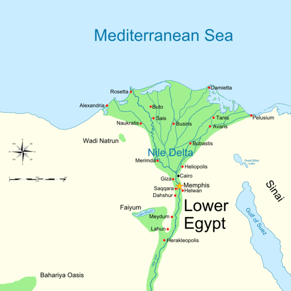
English: Map of Lower Ancient Egypt, showing the Nile and major cities and sites of the Dynastic period (c. 3150 BC to 30 BC). |
| Data | (UTC) |
| Jatorria | |
| Egilea |
|
| Beste bertsioak |
Derivative works of this file: |

|
Irudi hau birsortu beharko litzateke SVG irudi bektorial moduan. Honek abantaila asko ematen ditu, ikus Commons:Media for cleanup (ingelesez) informazio gehiagorako. Irudi honen SVG bertsioa eskuragarri badago, mesedez Commonsera igo. Igo ostean, ordezkatu txantiloi hau txantiloi honegatik {{vector version available|irudiaren izen berria.svg}} irudi honetan.
|
| This is a retouched picture, which means that it has been digitally altered from its original version. Modifications: Cropped image to use as base map. The original can be viewed here: Ancient Egypt map-en.svg:
|
Lizentzia
Nik, lan honen egileak, argitaratzen dut ondorengo lizentzia hauen pean:
This file is licensed under the Creative Commons Attribution-Share Alike 3.0 Unported, 2.5 Generic, 2.0 Generic and 1.0 Generic license.
- Askea zara:
- partekatzeko – lana kopiatzeko, banatzeko eta bidaltzeko
- birnahasteko – lana moldatzeko
- Ondorengo baldintzen pean:
- eskuduntza – Egiletza behar bezala aitortu behar duzu, lizentzia ikusteko esteka gehitu, eta ea aldaketak egin diren aipatu. Era egokian egin behar duzu hori guztia, baina inola ere ez egileak zure lana edo zure erabilera babesten duela irudikatuz.
- berdin partekatu – Lan honetan oinarrituta edo aldatuta berria eraikitzen baduzu, emaitza lana hau bezalako lizentzia batekin argitaratu behar duzu.

|
Baimena duzu dokumentu hau kopiatu, banatu edo/eta aldatzeko GNU Free Documentation License baldintzapean, Free Software Foundationek argitaratutako 1.2 edo ondorengo bertsioan; sekzio aldaezinik gabe, azaleko testurik gabe, eta atzeko azaleko testurik gabe. Lizentziaren kopia dago GNU Free Documentation License izenburudun atalean. |
Nahiago duzun lizentzia erabil dezakezu.
Jatorrizko igoera erregistroa
This image is a derivative work of the following images:
- File:Ancient_Egypt_map-en.svg licensed with Cc-by-sa-3.0,2.5,2.0,1.0, GFDL
- 2009-02-20T11:28:29Z Bibi Saint-Pol 1577x3219 (422457 Bytes) fix translation mistake on the windrose
- 2009-01-30T12:13:53Z Bibi Saint-Pol 1577x3219 (422444 Bytes) fix position of Nile Delta
- 2009-01-29T12:21:11Z Bibi Saint-Pol 1577x3219 (422383 Bytes) remove wrong text, adjust frame
- 2009-01-29T12:05:11Z Bibi Saint-Pol 1577x3219 (422757 Bytes) {{Assessments|1=Ancient Egypt map.svg|enwiki=1}} __NOTOC__ == {{int:filedesc}} == {{inkscape}} {{Information |Description= {{en|Map of Ancient Egypt, showing the Nile up to the fifth cataract, and major cities and sites of th
Uploaded with derivativeFX
Fitxategiaren historia
Data/orduan klik egin fitxategiak orduan zuen itxura ikusteko.
| Data/Ordua | Iruditxoa | Neurriak | Erabiltzailea | Iruzkina | |
|---|---|---|---|---|---|
| oraingoa | 18:30, 14 otsaila 2014 | | 994 × 994 (188 KB) | Andy king50 | -border |
| 20:00, 29 ekaina 2009 |  | 1.000 × 1.000 (193 KB) | MinisterForBadTimes | Hopefully fixed border this time | |
| 19:59, 29 ekaina 2009 |  | 1.000 × 1.000 (193 KB) | MinisterForBadTimes | Moved border | |
| 19:57, 29 ekaina 2009 |  | 1.000 × 1.000 (193 KB) | MinisterForBadTimes | Added border | |
| 19:49, 29 ekaina 2009 |  | 1.000 × 1.000 (190 KB) | MinisterForBadTimes | {{Information |Description={{en|Map of Lower Ancient Egypt, showing the Nile and major cities and sites of the Dynastic period (c. 3150 BC to 30 BC). |Source=*File:Ancient_Egypt_map-en.svg |Date=2009-06-29 18:49 (UTC) |Author=*[[:File:Ancient_Egypt_ |
Irudira dakarten loturak
Hurrengo orrialdeek dute fitxategi honetarako lotura:
Fitxategiaren erabilera orokorra
Hurrengo beste wikiek fitxategi hau darabilte:
- ar.wikipedia.org proiektuan duen erabilera
- arz.wikipedia.org proiektuan duen erabilera
- az.wikipedia.org proiektuan duen erabilera
- bg.wikipedia.org proiektuan duen erabilera
- br.wikipedia.org proiektuan duen erabilera
- cs.wikipedia.org proiektuan duen erabilera
- de.wikipedia.org proiektuan duen erabilera
- de.wikivoyage.org proiektuan duen erabilera
- el.wikipedia.org proiektuan duen erabilera
- en.wikipedia.org proiektuan duen erabilera
- es.wikipedia.org proiektuan duen erabilera
- et.wikipedia.org proiektuan duen erabilera
- fr.wikipedia.org proiektuan duen erabilera
- he.wikipedia.org proiektuan duen erabilera
- hu.wikipedia.org proiektuan duen erabilera
- it.wikipedia.org proiektuan duen erabilera
- ja.wikipedia.org proiektuan duen erabilera
- ja.wikibooks.org proiektuan duen erabilera
Ikus fitxategi honen erabilpen global gehiago.