Fitxategi:Map of 2021 Cumbre Vieja eruption.png

Orriaren edukia ez da onartzen beste hizkuntza batzuetan.
Wikipedia, Entziklopedia askea

Bereizmen handikoa((715 × 937 pixel, fitxategiaren tamaina: 596 KB, MIME mota: image/png))

Fitxategi hau Wikimedia Commonsekoa da. Hango deskribapen orriko informazioa behean duzu.
Commons gordailu bat da, lizentzia askea duten multimedia fitxategiena. Lagun dezakezu.

Fitxategi hau Wikimedia Commonsekoa da

Laburpena

Deskribapena
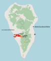
English: Map describing the 2021 Cumbre Vieja volcanic eruption, with location of the volcano shown together with the range of lava coverage (as of 23/11/2021), the capital city, airport and location of centres of destroyed localities of Todoque and La Laguna

Sources:

  • Shape of the island, land coverage, main roads, location of airport - OpenStreetMap data
  • Lava extent - Copernicus Project
  • Location of centres of towns/villages - Nomenclátor Geográfico de Municipios y Entidades de Población
  • Hillshade - processing of data from the SRTM mission
Polski: Mapa opisująca erupcję wulkanu Cumbre Vieja w 2021 roku, z lokalizacją wulkanu, zasięgiem pokrycia lawą (stan na 23.11.2021), stolicą, lotniskiem oraz zniszczonymi miejscowościami


Źródła:

  • Kształt wyspy, pokrycie terenu, główne drogi, lokalizacja lotniska - dane OpenStreetMap
  • Zasięg pokrycia lawą - Copernicus Project
  • Lokalizacja centrów miejscowości - Nomenclátor Geográfico de Municipios y Entidades de Población
  • Hillshade - przetworzone dane z misji SRTM
Data
Jatorria Norberak egina
Egilea Jakub Kaczorowski
 
Fitxategi hau PNG (irudia) hau QGIS-ekin sortu da .

Lizentzia

Nik, lan honen egileak, argitaratzen dut ondorengo lizentzia pean:
w:eu:Creative Commons
eskuduntza berdin partekatu
This file is licensed under the Creative Commons Attribution-Share Alike 4.0 International license.
Askea zara:
  • partekatzeko – lana kopiatzeko, banatzeko eta bidaltzeko
  • birnahasteko – lana moldatzeko
Ondorengo baldintzen pean:
  • eskuduntza – Egiletza behar bezala aitortu behar duzu, lizentzia ikusteko esteka gehitu, eta ea aldaketak egin diren aipatu. Era egokian egin behar duzu hori guztia, baina inola ere ez egileak zure lana edo zure erabilera babesten duela irudikatuz.
  • berdin partekatu – Lan honetan oinarrituta edo aldatuta berria eraikitzen baduzu, emaitza lana hau bezalako lizentzia batekin argitaratu behar duzu.

Irudi-oineko testuak

Add a one-line explanation of what this file represents

17 urria 2021

media type ingelesa

image/png

Fitxategiaren historia

Data/orduan klik egin fitxategiak orduan zuen itxura ikusteko.

Data/OrduaIruditxoaNeurriakErabiltzaileaIruzkina
oraingoa20:24, 24 azaroa 202120:24, 24 azaroa 2021 bertsioaren iruditxoa715 × 937 (596 KB)Kubek15updating lava extent
12:56, 18 azaroa 202112:56, 18 azaroa 2021 bertsioaren iruditxoa707 × 933 (592 KB)Kubek15remove double scale bar
12:53, 18 azaroa 202112:53, 18 azaroa 2021 bertsioaren iruditxoa744 × 938 (585 KB)Kubek15Updating lava flow as of 12/11/2021
23:51, 29 urria 202123:51, 29 urria 2021 bertsioaren iruditxoa716 × 926 (593 KB)Kubek15fixed minor graphic error
23:49, 29 urria 202123:49, 29 urria 2021 bertsioaren iruditxoa744 × 938 (595 KB)Kubek15Added DEM, improved graphics and updated range of lava field cover
21:30, 17 urria 202121:30, 17 urria 2021 bertsioaren iruditxoa543 × 671 (85 KB)Kubek15fixed typo
21:27, 17 urria 202121:27, 17 urria 2021 bertsioaren iruditxoa535 × 634 (91 KB)Kubek15Uploaded own work with UploadWizard

Hurrengo orrialdeek dute fitxategi honetarako lotura:

Fitxategiaren erabilera orokorra

Hurrengo beste wikiek fitxategi hau darabilte:

Metadatuak