
Fitxategi:Map of Glacier National Park.PNG

Aurreikuspen honen neurria: 527 × 600 pixel. Bestelako bereizmenak: 211 × 240 pixel | 422 × 480 pixel | 675 × 768 pixel | 900 × 1.024 pixel | 1.657 × 1.885 pixel.
Bereizmen handikoa ((1.657 × 1.885 pixel, fitxategiaren tamaina: 2,44 MB, MIME mota: image/png))
Fitxategi hau Wikimedia Commonsekoa da. Hango deskribapen orriko informazioa behean duzu. |
Laburpena
| Deskribapena |
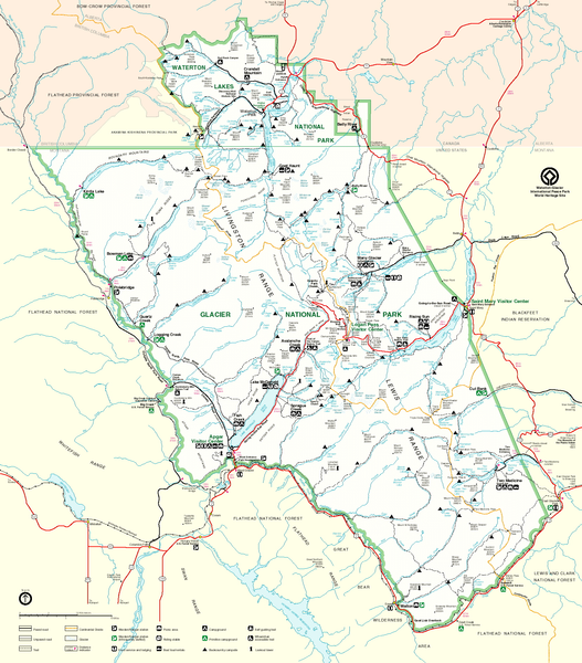
English: Map of Glacier National Park, Montana, USA and Waterton Lakes National Park, Alberta, Canada |
| Jatorria | http://www.nps.gov/glac/images/bigmap.gif |
| Egilea | US-NPS |
Lizentzia
| This image or media file contains material based on a work of a National Park Service employee, created as part of that person's official duties. As a work of the U.S. federal government, such work is in the public domain in the United States. See the NPS website and NPS copyright policy for more information. |
Fitxategiaren historia
Data/orduan klik egin fitxategiak orduan zuen itxura ikusteko.
| Data/Ordua | Iruditxoa | Neurriak | Erabiltzailea | Iruzkina | |
|---|---|---|---|---|---|
| oraingoa | 13:01, 13 maiatza 2006 | | 1.657 × 1.885 (2,44 MB) | MONGO | {{Information| |Description=Map of Glacier National Park |Source=http://www.nps.gov/glac/images/bigmap.gif |Date= |Author= |Permission= |other_versions= }} |
Irudira dakarten loturak
Hurrengo orrialdeek dute fitxategi honetarako lotura:
Fitxategiaren erabilera orokorra
Hurrengo beste wikiek fitxategi hau darabilte:
- ar.wikipedia.org proiektuan duen erabilera
- ca.wikipedia.org proiektuan duen erabilera
- da.wikipedia.org proiektuan duen erabilera
- en.wikipedia.org proiektuan duen erabilera
- es.wikipedia.org proiektuan duen erabilera
- fr.wikipedia.org proiektuan duen erabilera
- he.wikipedia.org proiektuan duen erabilera
- hy.wikipedia.org proiektuan duen erabilera
- it.wikipedia.org proiektuan duen erabilera
- no.wikipedia.org proiektuan duen erabilera
- pl.wikipedia.org proiektuan duen erabilera
- ru.wikipedia.org proiektuan duen erabilera
- tr.wikipedia.org proiektuan duen erabilera
- uk.wikipedia.org proiektuan duen erabilera
- vi.wikipedia.org proiektuan duen erabilera