
Fitxategi:Map of comune of Villanovaforru (province of South Sardinia, region Sardinia, Italy) - 2016.svg

SVG fitxategi honen PNG aurreikuspenaren tamaina: 623 × 599 pixel. Bestelako bereizmenak: 250 × 240 pixel | 499 × 480 pixel | 799 × 768 pixel | 1.065 × 1.024 pixel | 2.129 × 2.048 pixel | 7.850 × 7.550 pixel.
Bereizmen handikoa (SVG fitxategia, nominaldi 7.850 × 7.550 pixel, fitxategiaren tamaina: 215 KB)
Fitxategi hau Wikimedia Commonsekoa da. Hango deskribapen orriko informazioa behean duzu. |
_-_2016.svg)
Laburpena
| Deskribapena |
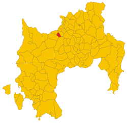
Italiano: Mappa valida a partire dal 2016. Immagine derivata dal file
English: Map of comune as of 2016 |
| Data | |
| Jatorria | Norberak egina |
| Egilea | Discanto |
W3C-validity not checked.
Lizentzia
Nik, lan honen egileak, argitaratzen dut ondorengo lizentzia pean:
| This file is made available under the Creative Commons CC0 1.0 Universal Public Domain Dedication. | |
| The person who associated a work with this deed has dedicated the work to the public domain by waiving all of their rights to the work worldwide under copyright law, including all related and neighboring rights, to the extent allowed by law. You can copy, modify, distribute and perform the work, even for commercial purposes, all without asking permission.
|
Fitxategiaren historia
Data/orduan klik egin fitxategiak orduan zuen itxura ikusteko.
| Data/Ordua | Iruditxoa | Neurriak | Erabiltzailea | Iruzkina | |
|---|---|---|---|---|---|
| oraingoa | 03:03, 2 abuztua 2017 | | 7.850 × 7.550 (215 KB) | Discanto | User created page with UploadWizard |
Irudira dakarten loturak
Hurrengo orrialdeek dute fitxategi honetarako lotura:
Fitxategiaren erabilera orokorra
Hurrengo beste wikiek fitxategi hau darabilte:
- ar.wikipedia.org proiektuan duen erabilera
- bg.wikipedia.org proiektuan duen erabilera
- ca.wikipedia.org proiektuan duen erabilera
- es.wikipedia.org proiektuan duen erabilera
- fi.wikipedia.org proiektuan duen erabilera
- fr.wikipedia.org proiektuan duen erabilera
- hu.wikipedia.org proiektuan duen erabilera
- ia.wikipedia.org proiektuan duen erabilera
- incubator.wikimedia.org proiektuan duen erabilera
- it.wikipedia.org proiektuan duen erabilera
- ja.wikipedia.org proiektuan duen erabilera
- la.wikipedia.org proiektuan duen erabilera
- lmo.wikipedia.org proiektuan duen erabilera
- sv.wikipedia.org proiektuan duen erabilera
- tt.wikipedia.org proiektuan duen erabilera
- www.wikidata.org proiektuan duen erabilera
_-_2016.svg)