
Fitxategi:Maricopa County Incorporated and Planning areas Chandler highlighted.svg

SVG fitxategi honen PNG aurreikuspenaren tamaina: 694 × 599 pixel. Bestelako bereizmenak: 278 × 240 pixel | 556 × 480 pixel | 889 × 768 pixel | 1.185 × 1.024 pixel | 2.371 × 2.048 pixel | 940 × 812 pixel.
Bereizmen handikoa (SVG fitxategia, nominaldi 940 × 812 pixel, fitxategiaren tamaina: 1,05 MB)
Fitxategi hau Wikimedia Commonsekoa da. Hango deskribapen orriko informazioa behean duzu. |
Laburpena
| Deskribapena |
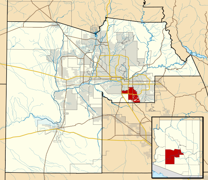
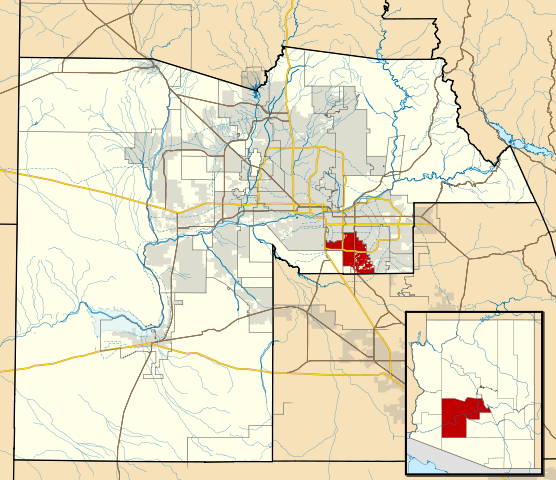
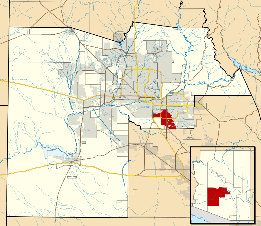
This map shows the incorporated areas and Indian reservation boundaries in Maricopa County, Arizona, along with water bodies and major highways and roads.
|
| Data | |
| Jatorria | My own work, based on government information |
| Egilea | Ixnayonthetimmay |
| Lizentzia (Fitxategi hau berrerabiltzen) |
Public Domain |
| Beste bertsioak | See Category:Maps of Maricopa County for other versions of this image. |
Lizentzia
| Nik, lan honen egile eskubideen jabeak, lan hau domeinu publikoan jartzen dut. Mundu osoan du eragina honek. Estatu batzuetan beharbada hori ez da legez posible izango. Halakoetan: Edonori ematen diot lan hau edozertarako erabiltzeko eskubidea, inolako baldintzarik gabe, legeak nahitaez ezarritako baldintzak izan ezik. |
Fitxategiaren historia
Data/orduan klik egin fitxategiak orduan zuen itxura ikusteko.
| Data/Ordua | Iruditxoa | Neurriak | Erabiltzailea | Iruzkina | |
|---|---|---|---|---|---|
| oraingoa | 08:15, 20 maiatza 2011 | | 940 × 812 (1,05 MB) | Ixnayonthetimmay | Uploading new version |
| 06:01, 30 abuztua 2008 |  | 900 × 800 (413 KB) | Ixnayonthetimmay | == Summary == {{Information |Description=This map shows the incorporated areas and unincorporated areas in Maricopa County, Arizona. [[:en:Chandler, Arizona| | |
| 01:57, 16 iraila 2007 |  | 900 × 800 (384 KB) | Ixnayonthetimmay | ||
| 01:56, 16 iraila 2007 |  | 900 × 800 (384 KB) | Ixnayonthetimmay | == Summary == {{Information |Description=This map shows the incorporated areas in Maricopa County, Arizona. It also shows the boundaries for the municipal planning areas. The [[:en:Fort | |
| 11:52, 28 maiatza 2007 |  | 900 × 780 (329 KB) | Ixnayonthetimmay | ||
| 01:54, 22 maiatza 2007 |  | 900 × 780 (318 KB) | Ixnayonthetimmay | ||
| 06:55, 30 urtarrila 2007 |  | 904 × 758 (177 KB) | Ixnayonthetimmay | {{Information |Description=This map shows the incorporated areas in Maricopa County, Arizona, highlighting Chandler in red. It also shows the boundaries for the |
Irudira dakarten loturak
Hurrengo orrialdeek dute fitxategi honetarako lotura:
Fitxategiaren erabilera orokorra
Hurrengo beste wikiek fitxategi hau darabilte:
- ar.wikipedia.org proiektuan duen erabilera
- arz.wikipedia.org proiektuan duen erabilera
- br.wikipedia.org proiektuan duen erabilera
- ca.wikipedia.org proiektuan duen erabilera
- ceb.wikipedia.org proiektuan duen erabilera
- de.wikipedia.org proiektuan duen erabilera
- el.wikipedia.org proiektuan duen erabilera
- eo.wikipedia.org proiektuan duen erabilera
- es.wikipedia.org proiektuan duen erabilera
- fi.wikipedia.org proiektuan duen erabilera
- fr.wikipedia.org proiektuan duen erabilera
- ga.wikipedia.org proiektuan duen erabilera
- ht.wikipedia.org proiektuan duen erabilera
- hu.wikipedia.org proiektuan duen erabilera
- id.wikipedia.org proiektuan duen erabilera
- it.wikipedia.org proiektuan duen erabilera
- ja.wikipedia.org proiektuan duen erabilera
- kw.wikipedia.org proiektuan duen erabilera
- mg.wikipedia.org proiektuan duen erabilera
- pl.wikipedia.org proiektuan duen erabilera
- pt.wikipedia.org proiektuan duen erabilera
- ro.wikipedia.org proiektuan duen erabilera
- sr.wikipedia.org proiektuan duen erabilera
- sv.wikipedia.org proiektuan duen erabilera
- sw.wikipedia.org proiektuan duen erabilera
- tt.wikipedia.org proiektuan duen erabilera
- ur.wikipedia.org proiektuan duen erabilera
- vi.wikipedia.org proiektuan duen erabilera
- vo.wikipedia.org proiektuan duen erabilera
- www.wikidata.org proiektuan duen erabilera
- zh.wikipedia.org proiektuan duen erabilera