
Fitxategi:Morrison Formation Brachiosauridae map.png

Aurreikuspen honen neurria: 627 × 600 pixel. Bestelako bereizmenak: 251 × 240 pixel | 502 × 480 pixel | 803 × 768 pixel | 1.071 × 1.024 pixel | 2.540 × 2.429 pixel.
Bereizmen handikoa ((2.540 × 2.429 pixel, fitxategiaren tamaina: 73 KB, MIME mota: image/png))
Fitxategi hau Wikimedia Commonsekoa da. Hango deskribapen orriko informazioa behean duzu. |
Laburpena
| Deskribapena |
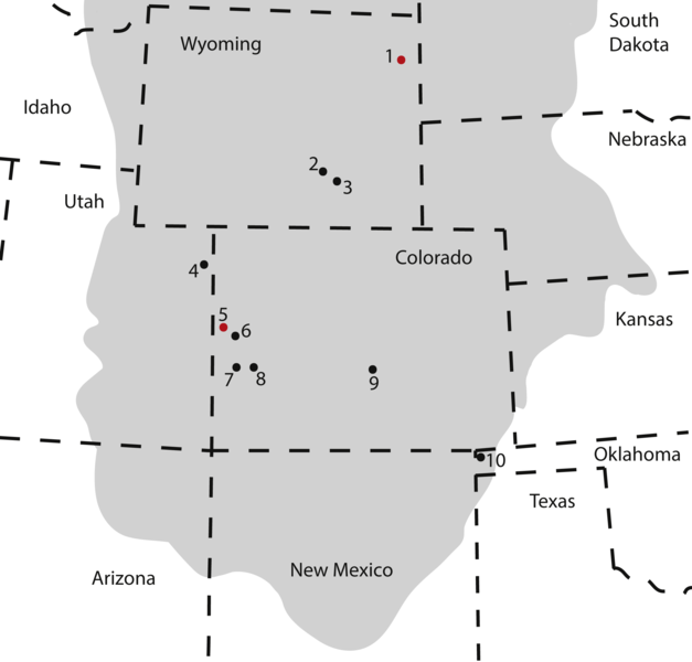
Map of occurrences of Brachiosauridae in the Upper Jurassic Morrison Formation. The locality of the pes described herein (1) and the type locality of Brachiosaurus altithorax (5) are highlighted in red. The gray area indicates the distribution of the Morrison Formation. 1, Bobcat Pit, Weston County, WY; 2, Freezeout Hills general, Carbon Co., WY; 3, Reed’s Quarry 13, Albany Co., WY; 4, Jensen/Jensen Quarry, Uintah Co., UT; 5, Fruita Paleontological Area general, Mesa Co., CO; 6, Riggs Quarry 13, Mesa Co., CO; 7, Dry Mesa Quarry, Mesa Co., CO; 8, Potter Creek Quarry, Montrose Co., CO; 9, Felch Quarry 1, Fremont Co., CO; 10, Kenton Pit 1, Cimarron Co., OK. Modified from Bonnan & Wedel (2004: fig. 2). |
| Data | |
| Jatorria | https://peerj.com/articles/5250/ |
| Egilea | Anthony Maltese, Emanuel Tschopp, Femke Holwerda, David Burnham |
| Lizentzia (Fitxategi hau berrerabiltzen) |
https://peerj.com/articles/5250.pdf |
Lizentzia
This file is licensed under the Creative Commons Attribution 4.0 International license.
- Askea zara:
- partekatzeko – lana kopiatzeko, banatzeko eta bidaltzeko
- birnahasteko – lana moldatzeko
- Ondorengo baldintzen pean:
- eskuduntza – Egiletza behar bezala aitortu behar duzu, lizentzia ikusteko esteka gehitu, eta ea aldaketak egin diren aipatu. Era egokian egin behar duzu hori guztia, baina inola ere ez egileak zure lana edo zure erabilera babesten duela irudikatuz.
This file, which was originally posted to
https://peerj.com/articles/5250/, was reviewed on 24 July 2018 by reviewer Guanaco, who confirmed that it was available there under the stated license on that date.
|
Fitxategiaren historia
Data/orduan klik egin fitxategiak orduan zuen itxura ikusteko.
| Data/Ordua | Iruditxoa | Neurriak | Erabiltzailea | Iruzkina | |
|---|---|---|---|---|---|
| oraingoa | 19:09, 10 abuztua 2018 | | 2.540 × 2.429 (73 KB) | HerrAdams | Cropped 1 % horizontally, 1 % vertically using CropTool with precise mode. Removed border. |
| 22:17, 24 uztaila 2018 |  | 2.571 × 2.460 (111 KB) | FunkMonk | == {{int:filedesc}} == {{Information |description=Map of occurrences of Brachiosauridae in the Upper Jurassic Morrison Formation. The locality of the pes described herein (1) and the type locality of Brachiosaurus altithorax (5) are highlighted in red. The gray area indicates the distribution of the Morrison Formation. 1, Bobcat Pit, Weston County, WY; 2, Freezeout Hills general, Carbon Co., WY; 3, Reed’s Quarry 13, Albany Co., WY; 4, Jensen/Jensen Quarry, Uintah Co., UT; 5, Fruita Paleontolo... |
Irudira dakarten loturak
Hurrengo orrialdeek dute fitxategi honetarako lotura:
Fitxategiaren erabilera orokorra
Hurrengo beste wikiek fitxategi hau darabilte:
- ar.wikipedia.org proiektuan duen erabilera
- ast.wikipedia.org proiektuan duen erabilera
- bg.wikipedia.org proiektuan duen erabilera
- ca.wikipedia.org proiektuan duen erabilera
- cs.wikipedia.org proiektuan duen erabilera
- en.wikipedia.org proiektuan duen erabilera
- he.wikipedia.org proiektuan duen erabilera
- hr.wikipedia.org proiektuan duen erabilera
- hu.wikipedia.org proiektuan duen erabilera
- mk.wikipedia.org proiektuan duen erabilera
- nn.wikipedia.org proiektuan duen erabilera
- pl.wikipedia.org proiektuan duen erabilera
- sv.wikipedia.org proiektuan duen erabilera
- tr.wikipedia.org proiektuan duen erabilera
- www.wikidata.org proiektuan duen erabilera
- zh.wikipedia.org proiektuan duen erabilera