
Fitxategi:NewBritainOMC.png
Ez dago bereizmen handiagorik.
NewBritainOMC.png ((491 × 349 pixel, fitxategiaren tamaina: 10 KB, MIME mota: image/png))
Fitxategi hau Wikimedia Commonsekoa da. Hango deskribapen orriko informazioa behean duzu. |
Laburpena
| Deskribapena |
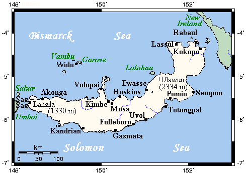
English: A map showing main towns and volcanoes of New Britain, Bismarck Archipelago, Papau New Guinea |
| Jatorria | This map's source is here, with the uploader's modifications, and the GMT homepage says that the tools are released under the GNU General Public License |
| Egilea | unknown, modified by Kelisi (talk) |
| Lizentzia (Fitxategi hau berrerabiltzen) |
GFDL-SELF-WITH-DISCLAIMERS; Released under the GNU Free Documentation License |
Lizentzia
Kelisi, lan honen egileak, argitaratu du edo argitaratzen du ondorengo lizentzia pean:
| Fitxategi hau Creative Commons Attribution-Share Alike 3.0 Unported lizentziapean dago. Subject to disclaimers. | ||
| Aitortu: Kelisi | ||
| ||
| This licensing tag was added to this file as part of the GFDL licensing update. |

|
Baimena duzu dokumentu hau kopiatu, banatu edo/eta aldatzeko GNU Free Documentation License baldintzapean, Free Software Foundationek argitaratutako 1.2 edo ondorengo bertsioan; sekzio aldaezinik gabe, azaleko testurik gabe, eta atzeko azaleko testurik gabe. Lizentziaren kopia dago GNU Free Documentation License izenburudun atalean. Subject to disclaimers. |
Jatorrizko igoera erregistroa
All following user names refer to en.wikipedia.
- 2007-07-21 21:43 Kelisi 491×349×8 (10649 bytes) Sorry, forgot scale.
- 2007-07-21 20:12 Kelisi 491×349×8 (10420 bytes) A map showing New Britain's main towns and volcanoes. This map's source is [http://www.aquarius.ifm-geomar.de/ here], with the uploader's modifications, and the [http://gmt.soest.hawaii.edu/ GMT homepage] says that the tools are released und
Fitxategiaren historia
Data/orduan klik egin fitxategiak orduan zuen itxura ikusteko.
| Data/Ordua | Iruditxoa | Neurriak | Erabiltzailea | Iruzkina | |
|---|---|---|---|---|---|
| oraingoa | 16:01, 27 urtarrila 2008 | | 491 × 349 (10 KB) | File Upload Bot (Magnus Manske) | {{BotMoveToCommons|en.wikipedia}} {{Information |Description={{en|A map showing New Britain's main towns and volcanoes. This map's source is [http://www.aquarius.ifm-geomar.de/ here], with the uploader's modifications, and the [http://gmt.soest.hawaii.ed |
Irudira dakarten loturak
Ez dago fitxategi hau darabilen orririk.
Fitxategiaren erabilera orokorra
Hurrengo beste wikiek fitxategi hau darabilte:
- af.wikipedia.org proiektuan duen erabilera
- az.wikipedia.org proiektuan duen erabilera
- ba.wikipedia.org proiektuan duen erabilera
- bg.wikipedia.org proiektuan duen erabilera
- bs.wikipedia.org proiektuan duen erabilera
- cy.wikipedia.org proiektuan duen erabilera
- da.wikipedia.org proiektuan duen erabilera
- diq.wikipedia.org proiektuan duen erabilera
- en.wikipedia.org proiektuan duen erabilera
- eo.wikipedia.org proiektuan duen erabilera
- es.wikipedia.org proiektuan duen erabilera
- ga.wikipedia.org proiektuan duen erabilera
- gl.wikipedia.org proiektuan duen erabilera
- he.wikipedia.org proiektuan duen erabilera
- hr.wikipedia.org proiektuan duen erabilera
- hu.wikipedia.org proiektuan duen erabilera
- hy.wikipedia.org proiektuan duen erabilera
- it.wikipedia.org proiektuan duen erabilera
- ja.wikipedia.org proiektuan duen erabilera
- ka.wikipedia.org proiektuan duen erabilera
- kk.wikipedia.org proiektuan duen erabilera
- lt.wikipedia.org proiektuan duen erabilera
- mrj.wikipedia.org proiektuan duen erabilera
- nl.wikipedia.org proiektuan duen erabilera
- nn.wikipedia.org proiektuan duen erabilera
- ro.wikipedia.org proiektuan duen erabilera
- ru.wikipedia.org proiektuan duen erabilera
- sr.wikipedia.org proiektuan duen erabilera
- sw.wikipedia.org proiektuan duen erabilera
- ta.wikipedia.org proiektuan duen erabilera
- tpi.wikipedia.org proiektuan duen erabilera
- tr.wikipedia.org proiektuan duen erabilera
- uk.wikipedia.org proiektuan duen erabilera
- vi.wikipedia.org proiektuan duen erabilera