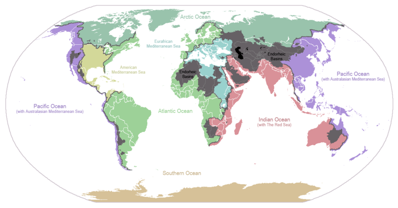
Fitxategi:Ocean drainage.png

Aurreikuspen honen neurria: 800 × 418 pixel. Bestelako bereizmenak: 320 × 167 pixel | 640 × 334 pixel | 1.256 × 656 pixel.
Bereizmen handikoa ((1.256 × 656 pixel, fitxategiaren tamaina: 75 KB, MIME mota: image/png))
Fitxategiaren historia
Data/orduan klik egin fitxategiak orduan zuen itxura ikusteko.
| Data/Ordua | Iruditxoa | Neurriak | Erabiltzailea | Iruzkina | |
|---|---|---|---|---|---|
| oraingoa | 01:25, 7 urria 2015 |  | 1.256 × 656 (75 KB) | AcidSnow | Fixed Somalia. |
| 02:39, 12 martxoa 2011 |  | 1.256 × 656 (76 KB) | W like wiki | Insert Description. Big font size is used for oceans, smaller font size is used for mediterranean seas. | |
| 13:13, 30 ekaina 2009 |  | 1.256 × 656 (40 KB) | U7vGun | transparentize background,improve some details. | |
| 22:45, 26 uztaila 2008 |  | 1.256 × 656 (62 KB) | Citynoise | {{Information |Description=added endorheic basins in Saskatchewan. |Source=my own work |Date=July 2008 |Author=Citynoise |Permission=all rights released |other_versions= }} | |
| 21:46, 27 azaroa 2007 |  | 1.256 × 656 (49 KB) | File Upload Bot (Magnus Manske) | {{BotMoveToCommons|en.wikipedia}} {{Information |Description={{en|I made this map and hereby release it into the public domain. It shows the drainage basins for the major oceans and seas; grey areas are en:endorheic basins that do not drain to the |
Irudira dakarten loturak
Hurrengo orrialdeek dute fitxategi honetarako lotura:
Fitxategiaren erabilera orokorra
Hurrengo beste wikiek fitxategi hau darabilte:
- af.wikipedia.org proiektuan duen erabilera
- als.wikipedia.org proiektuan duen erabilera
- ar.wikipedia.org proiektuan duen erabilera
- ast.wikipedia.org proiektuan duen erabilera
- av.wikipedia.org proiektuan duen erabilera
- az.wikipedia.org proiektuan duen erabilera
- ba.wikipedia.org proiektuan duen erabilera
- be.wikipedia.org proiektuan duen erabilera
- bg.wikipedia.org proiektuan duen erabilera
- bn.wikipedia.org proiektuan duen erabilera
- bs.wikipedia.org proiektuan duen erabilera
- ca.wikipedia.org proiektuan duen erabilera
- ceb.wikipedia.org proiektuan duen erabilera
- cs.wikipedia.org proiektuan duen erabilera
- da.wikipedia.org proiektuan duen erabilera
- da.wikibooks.org proiektuan duen erabilera
- de.wikipedia.org proiektuan duen erabilera
- en.wikipedia.org proiektuan duen erabilera
- Biogeographic realm
- Drainage basin
- Global 200
- Endorheic basin
- List of rivers of the Americas by coastline
- List of drainage basins by area
- Marine life
- Marine sediment
- List of endorheic basins
- Portal:Maps/Maps/World
- Portal:Maps/Maps/World/22
- Continental divide
- Wikipedia:Graphics Lab/Map workshop/Archive/Jan 2010
- User:YanikB
- Triple divide
- Marine biogeochemical cycles
- eo.wikipedia.org proiektuan duen erabilera
Ikus fitxategi honen erabilpen global gehiago.


