
Fitxategi:Old Town, St. Mary's - geograph.org.uk - 929131.jpg
Ez dago bereizmen handiagorik.
Old_Town,_St._Mary's_-_geograph.org.uk_-_929131.jpg ((640 × 500 pixel, fitxategiaren tamaina: 343 KB, MIME mota: image/jpeg))
Fitxategi hau Wikimedia Commonsekoa da. Hango deskribapen orriko informazioa behean duzu. |
Laburpena
| Deskribapena |
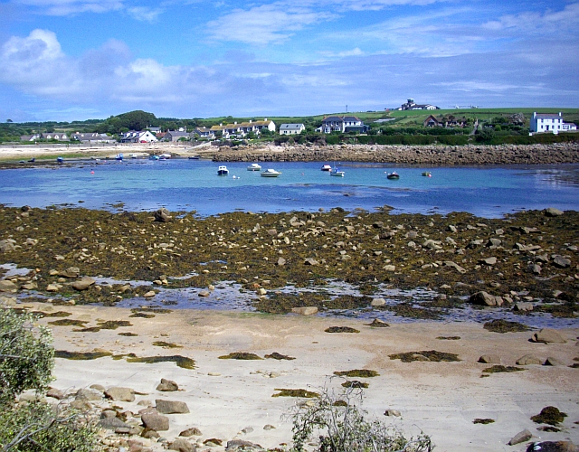
English: Old Town, St. Mary's Known as Porthennor when, in Medieval times, this was the most important harbour on Ennor (as the island of St. Mary's was then known). The tree covered lump on the horizon (left) is the site of the 13th century castle. An annual rent of 8d or 300 puffins was to be paid to the crown for this. The airport buildings can be seen on the right hand horizon. |
| Data | |
| Jatorria | From geograph.org.uk |
| Egilea | Bob Embleton |
| Aitortu (required by the license) | Bob Embleton / Old Town, St. Mary's / |
| Kameraren kokapena | | Irudi hau eta gehiago beraien kokapenekin hurrengo lekuetan: OpenStreetMap |
|---|
_heading:67.00&language=eu)
| Objektuaren kokapena | | Irudi hau eta gehiago beraien kokapenekin hurrengo lekuetan: OpenStreetMap |
|---|
_heading:67.00&language=eu)
Lizentzia

|
This image was taken from the Geograph project collection. See this photograph's page on the Geograph website for the photographer's contact details. The copyright on this image is owned by Bob Embleton and is licensed for reuse under the Creative Commons Attribution-ShareAlike 2.0 license.
|
This file is licensed under the Creative Commons Attribution-Share Alike 2.0 Generic license.
Aitortu: Bob Embleton
- Askea zara:
- partekatzeko – lana kopiatzeko, banatzeko eta bidaltzeko
- birnahasteko – lana moldatzeko
- Ondorengo baldintzen pean:
- eskuduntza – Egiletza behar bezala aitortu behar duzu, lizentzia ikusteko esteka gehitu, eta ea aldaketak egin diren aipatu. Era egokian egin behar duzu hori guztia, baina inola ere ez egileak zure lana edo zure erabilera babesten duela irudikatuz.
- berdin partekatu – Lan honetan oinarrituta edo aldatuta berria eraikitzen baduzu, emaitza lana hau bezalako lizentzia batekin argitaratu behar duzu.
Fitxategiaren historia
Data/orduan klik egin fitxategiak orduan zuen itxura ikusteko.
| Data/Ordua | Iruditxoa | Neurriak | Erabiltzailea | Iruzkina | |
|---|---|---|---|---|---|
| oraingoa | 05:29, 22 otsaila 2011 | | 640 × 500 (343 KB) | GeographBot | == {{int:filedesc}} == {{Information |description={{en|1=Old Town, St. Mary's Known as Porthennor when, in Medieval times, this was the most important harbour on Ennor (as the island of St. Mary's was then known). The tree covered lump on the horizon (lef |
Irudira dakarten loturak
Hurrengo orrialdeek dute fitxategi honetarako lotura:
Fitxategiaren erabilera orokorra
Hurrengo beste wikiek fitxategi hau darabilte:
- en.wikipedia.org proiektuan duen erabilera
- hy.wikipedia.org proiektuan duen erabilera
- it.wikipedia.org proiektuan duen erabilera