
Fitxategi:Old cadastral map of Praha-Josefov and surround areas.jpg

Bereizmen handikoa ((3.328 × 2.976 pixel, fitxategiaren tamaina: 4,73 MB, MIME mota: image/jpeg))
Fitxategi hau Wikimedia Commonsekoa da. Hango deskribapen orriko informazioa behean duzu. |
Laburpena
| Deskribapena |
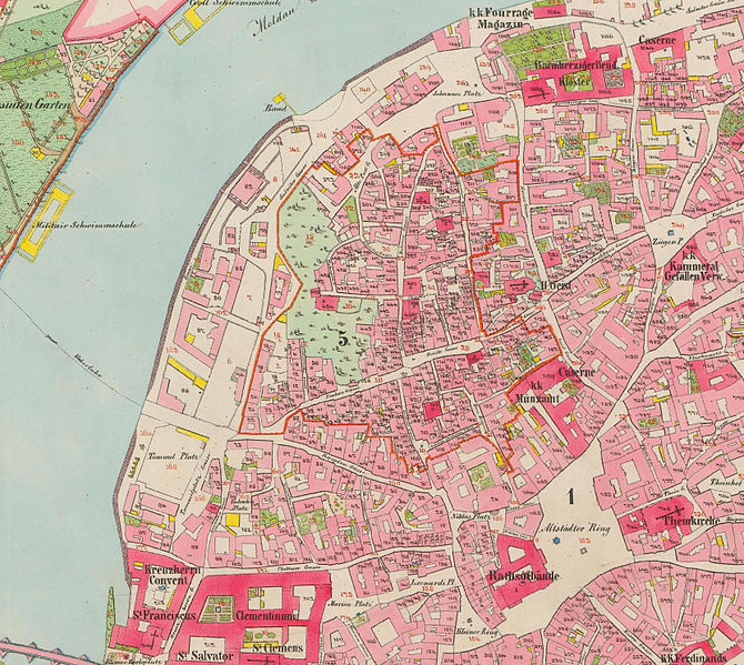
English: Old cadastral map of original Praha-Josefov cadastral area and surround areas
Čeština: Mapa stabilního katastru Prahy-Josefova s okolím, pocházející z řady povinných císařských otisků. Mapováno 1842, opravené vydání 1852. |
| Data | |
| Jatorria | http://archivnimapy.cuzk.cz/coc/6068-1/6068-1-002_index.html |
| Egilea | Offices of the Austrian Empire |
|
Lan hau jabetza publikoan dago bai bere jatorrizko herrialdean, bai egile eskubideak egilea hil eta 70 urtera edo gutxiagora iraungitzen diren gainerako herrialdeetan. This work is in the public domain in the United States because it was published (or registered with the U.S. Copyright Office) before January 1, 1929. | |
| This file has been identified as being free of known restrictions under copyright law, including all related and neighboring rights. | |

|
This file was created on the basis of data provided by the Central Archives of Surveying and Land Register (State Administration of Land Surveying and Cadastre).
|
Fitxategiaren historia
Data/orduan klik egin fitxategiak orduan zuen itxura ikusteko.
| Data/Ordua | Iruditxoa | Neurriak | Erabiltzailea | Iruzkina | |
|---|---|---|---|---|---|
| oraingoa | 17:04, 28 urtarrila 2015 | | 3.328 × 2.976 (4,73 MB) | MagentaGreen | Wasserzeichen entfernt; Bildzuschnitt (Vielfaches von 16 px); Photoshop Speicheroptionen: Qualität 11 (97%) |
| 00:46, 28 urtarrila 2013 |  | 3.331 × 2.981 (6,87 MB) | Slick-o-bot | Bot: convert to a non-interlaced jpeg (see bug #17645) | |
| 01:07, 5 ekaina 2008 |  | 3.331 × 2.981 (6,16 MB) | Kirk979 | {{Information |Description={{en|1=Old cadastral map of original Praha-Josefov cadastral area and surround areas}} {{cs|1=Stará katastrální mapa původního katastru Prahy-Josefova s okolím, pocházející z řady povinných císařských otisků}} |So |
Irudira dakarten loturak
Hurrengo orrialdeek dute fitxategi honetarako lotura:
Fitxategiaren erabilera orokorra
Hurrengo beste wikiek fitxategi hau darabilte:
- cs.wikipedia.org proiektuan duen erabilera
- de.wikipedia.org proiektuan duen erabilera