
Fitxategi:Persian Empire, 490 BC.png
Aurreikuspen honen neurria: 800 × 577 pixel. Bestelako bereizmenak: 320 × 231 pixel | 640 × 461 pixel | 946 × 682 pixel.
Bereizmen handikoa ((946 × 682 pixel, fitxategiaren tamaina: 159 KB, MIME mota: image/png))
Fitxategi hau Wikimedia Commonsekoa da. Hango deskribapen orriko informazioa behean duzu. |
Laburpena
| Deskribapena |
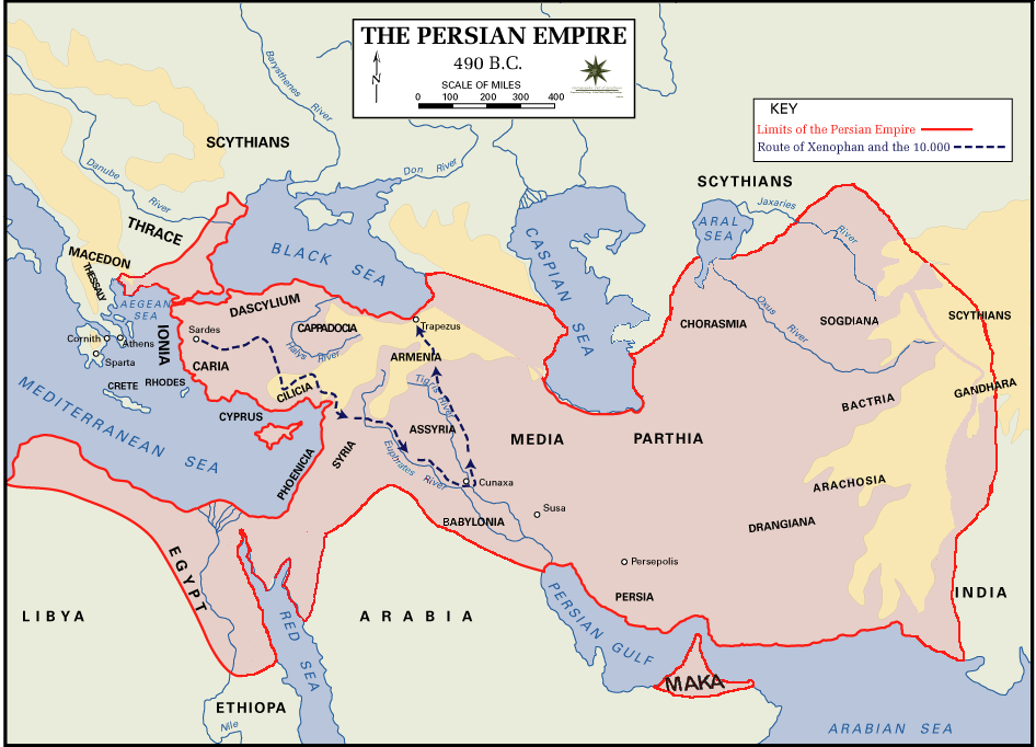
 English: Persian Empire, 490 BC, showing route of Cyrus the Younger, Xenophon and the 10.000.
Legends:
|
| Data | |
| Jatorria | The Department of History - United States Military Academy |
| Egilea | DHUSMA |
| Lizentzia (Fitxategi hau berrerabiltzen) |
In the public domain as original works of the United States federal government and/or military |
| Beste bertsioak | For a version of this image altered to display better in Wikipedia articles (converted to PNG format, slightly cropped in File:Persian Empire, 490 BC.gif) y Italian version. |

|
Irudi hau birsortu beharko litzateke SVG irudi bektorial moduan. Honek abantaila asko ematen ditu, ikus Commons:Media for cleanup (ingelesez) informazio gehiagorako. Irudi honen SVG bertsioa eskuragarri badago, mesedez Commonsera igo. Igo ostean, ordezkatu txantiloi hau txantiloi honegatik {{vector version available|irudiaren izen berria.svg}} irudi honetan.
|
Lizentzia
Lan hau Ameriketako Estatu Batuetako jabetza publikoan dago, lanaren iturria Estatu Batuetako gobernu federala delako eta Ameriketako Estatu Batuetako Kodeko 17. titulu, 1. kapitulu, 105. atal-aren arabera. Ikus Copyright.
Oharra: Estatutu hau gobernu federalaren lanetan aplikatzen da bakarrik eta ez AEBetako estatu, lurralde, konderri, azpibanaketa edo udalerriren lanetan.
|
 | |
| This file has been identified as being free of known restrictions under copyright law, including all related and neighboring rights. | ||
Fitxategiaren historia
Data/orduan klik egin fitxategiak orduan zuen itxura ikusteko.
| Data/Ordua | Iruditxoa | Neurriak | Erabiltzailea | Iruzkina | |
|---|---|---|---|---|---|
| oraingoa | 04:11, 2 abuztua 2015 | | 946 × 682 (159 KB) | History of Persia | Achaemenid Arabia. see wikipedia article about achaemenid arabia |
| 13:21, 11 apirila 2013 |  | 942 × 684 (64 KB) | HistoryofIran | {{subst:Upload marker added by en.wp UW}} {{Information |Description = {{en|Added another region named Maka, it was listen on the Behistun inscription as part of the Achaemenid Empire.}} |Source = https://en.wikipedia.org/wiki/File:Persian_Empire,_490_... | |
| 21:21, 10 apirila 2013 |  | 942 × 684 (64 KB) | HistoryofIran | Changed where Chorasmia was written, it was much closer to the Aral sea. | |
| 21:19, 10 apirila 2013 |  | 942 × 684 (64 KB) | HistoryofIran | Added a more accurate map. | |
| 00:55, 8 abendua 2012 |  | 942 × 684 (64 KB) | Geagea | Colchis and Caucasian Iberia. Not Georgia. | |
| 18:24, 25 azaroa 2012 |  | 942 × 684 (97 KB) | SilvioRusso | correction | |
| 02:49, 27 abuztua 2009 |  | 942 × 684 (64 KB) | AnonMoos | Version of File:Persian Empire, 490 BC.gif altered to display better in Wikipedia articles (converted to PNG format, slightly cropped). == Summary == ; Description : Persian Empire, 490 BC ; Author/Source : [http://www.dean.usma.edu/history/ The Depa |
Irudira dakarten loturak
Hurrengo orrialdeek dute fitxategi honetarako lotura:
Fitxategiaren erabilera orokorra
Hurrengo beste wikiek fitxategi hau darabilte:
- ast.wikipedia.org proiektuan duen erabilera
- bg.wikipedia.org proiektuan duen erabilera
- ca.wikipedia.org proiektuan duen erabilera
- cs.wikipedia.org proiektuan duen erabilera
- da.wikipedia.org proiektuan duen erabilera
- el.wikipedia.org proiektuan duen erabilera
- en.wikipedia.org proiektuan duen erabilera
- eo.wikipedia.org proiektuan duen erabilera
- fa.wikipedia.org proiektuan duen erabilera
- fr.wikipedia.org proiektuan duen erabilera
- fr.wikisource.org proiektuan duen erabilera
- fy.wikipedia.org proiektuan duen erabilera
- hr.wikipedia.org proiektuan duen erabilera
- hu.wikipedia.org proiektuan duen erabilera
- hy.wikipedia.org proiektuan duen erabilera
- id.wikipedia.org proiektuan duen erabilera
- it.wikipedia.org proiektuan duen erabilera
- ko.wikipedia.org proiektuan duen erabilera
- ku.wikipedia.org proiektuan duen erabilera
- la.wikipedia.org proiektuan duen erabilera
- nl.wikipedia.org proiektuan duen erabilera
- no.wikipedia.org proiektuan duen erabilera
- pnb.wikipedia.org proiektuan duen erabilera
- pnt.wikipedia.org proiektuan duen erabilera
- ro.wikipedia.org proiektuan duen erabilera
- ru.wikipedia.org proiektuan duen erabilera
- sh.wikipedia.org proiektuan duen erabilera
- sr.wikipedia.org proiektuan duen erabilera
Ikus fitxategi honen erabilpen global gehiago.