
Fitxategi:Relief Map of Germany, Black Forest.png

Aurreikuspen honen neurria: 506 × 600 pixel. Bestelako bereizmenak: 202 × 240 pixel | 405 × 480 pixel | 1.000 × 1.185 pixel.
Bereizmen handikoa ((1.000 × 1.185 pixel, fitxategiaren tamaina: 1,48 MB, MIME mota: image/png))
Fitxategi hau Wikimedia Commonsekoa da. Hango deskribapen orriko informazioa behean duzu. |
Laburpena
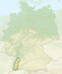
| Deskribapena |
English: Relief map of Germany with outlines of the Black Forest. Equirectangular projection, N/S stretching 150 %. Geographic limits of the map: * N: 55.1° N * S: 47.2° N * W: 5.5° E * E: 15.5° E
Deutsch: Deutschlandkarte mit Umrissen des Schwarzwalds gemäß Naturräumlichen Großregionen Deutschlands nach dem System des Bundesamtes für Naturschutz (BfN). |
| Data | (UTC) |
| Jatorria |
Fitxategi hau hemendik eratorria izan da: |
| Egilea |
|


Lizentzia
Fitxategi hau Creative Commons Attribution-Share Alike 3.0 Unported lizentziapean dago.
- Askea zara:
- partekatzeko – lana kopiatzeko, banatzeko eta bidaltzeko
- birnahasteko – lana moldatzeko
- Ondorengo baldintzen pean:
- eskuduntza – Egiletza behar bezala aitortu behar duzu, lizentzia ikusteko esteka gehitu, eta ea aldaketak egin diren aipatu. Era egokian egin behar duzu hori guztia, baina inola ere ez egileak zure lana edo zure erabilera babesten duela irudikatuz.
- berdin partekatu – Lan honetan oinarrituta edo aldatuta berria eraikitzen baduzu, emaitza lana hau bezalako lizentzia batekin argitaratu behar duzu.
Jatorrizko igoera erregistroa
This image is a derivative work of the following images:
- File:Relief_Map_of_Germany.png licensed with Cc-by-sa-3.0
- 2010-08-28T17:48:23Z Виктор В 1000x1185 (1796090 Bytes) Рельеф дна
- 2010-08-28T16:40:16Z Виктор В 1000x1185 (1733013 Bytes) мелкие исправления
- 2010-08-28T12:03:54Z Виктор В 1000x1185 (1766531 Bytes) == {{int:filedesc}} == {{Information |Description={{en|Relief map of [[:en:Germany|Germany]]}} [[:en:Equirectangular projection|Equirectangular projection]], N/S stretching 150 %. Geographic limits of the map: * N: 55.1° N *
- File:Deutschland_Naturraeumliche_Grossregionen.png licensed with Cc-by-sa-3.0, GFDL
- 2011-09-29T17:01:59Z NordNordWest 1826x2318 (5659071 Bytes) upd
- 2011-09-22T18:51:25Z NordNordWest 1826x2318 (5641169 Bytes) ergänzt
- 2011-09-14T18:57:42Z NordNordWest 1826x2318 (5615307 Bytes) update
- 2008-06-12T10:16:41Z NordNordWest 1980x2322 (5911072 Bytes)
- 2008-06-12T09:03:16Z NordNordWest 1979x2322 (5753037 Bytes)
- 2008-06-11T19:04:47Z NordNordWest 1979x2321 (5766960 Bytes) == Beschreibung == {{Information |Description= {{de|Karte der [[:de:Naturräumliche Haupteinheiten Deutschlands|Naturräumlichen Haupteinheiten Deutschlands]] nach dem System des [[:de:Bundesamt für Naturschutz|Bundesamtes f
Uploaded with derivativeFX
Fitxategiaren historia
Data/orduan klik egin fitxategiak orduan zuen itxura ikusteko.
| Data/Ordua | Iruditxoa | Neurriak | Erabiltzailea | Iruzkina | |
|---|---|---|---|---|---|
| oraingoa | 04:40, 28 uztaila 2013 | | 1.000 × 1.185 (1,48 MB) | Sitacuisses | == {{int:filedesc}} == {{Information |Description={{en|Relief map of Germany with outlines of the Black Forest. Equirectangular projection, N/S stretching 150 %. Geographic limits ... |
Irudira dakarten loturak
Hurrengo orrialdeek dute fitxategi honetarako lotura:
Fitxategiaren erabilera orokorra
Hurrengo beste wikiek fitxategi hau darabilte:
- af.wikipedia.org proiektuan duen erabilera
- arz.wikipedia.org proiektuan duen erabilera
- ast.wikipedia.org proiektuan duen erabilera
- bh.wikipedia.org proiektuan duen erabilera
- bn.wikipedia.org proiektuan duen erabilera
- ca.wikipedia.org proiektuan duen erabilera
- cs.wikipedia.org proiektuan duen erabilera
- da.wikipedia.org proiektuan duen erabilera
- de.wikipedia.org proiektuan duen erabilera
- en.wikipedia.org proiektuan duen erabilera
- en.wikivoyage.org proiektuan duen erabilera
- eo.wikipedia.org proiektuan duen erabilera
- es.wikipedia.org proiektuan duen erabilera
- fa.wikipedia.org proiektuan duen erabilera
- fi.wikipedia.org proiektuan duen erabilera
- fr.wikipedia.org proiektuan duen erabilera
- ga.wikipedia.org proiektuan duen erabilera
- he.wikipedia.org proiektuan duen erabilera
- it.wikivoyage.org proiektuan duen erabilera
- ja.wikipedia.org proiektuan duen erabilera
- ka.wikipedia.org proiektuan duen erabilera
- ml.wikipedia.org proiektuan duen erabilera
- pl.wikipedia.org proiektuan duen erabilera
- pl.wikivoyage.org proiektuan duen erabilera
- ro.wikipedia.org proiektuan duen erabilera
- sco.wikipedia.org proiektuan duen erabilera
- sk.wikipedia.org proiektuan duen erabilera
- sl.wikipedia.org proiektuan duen erabilera
- ta.wikipedia.org proiektuan duen erabilera
- th.wikipedia.org proiektuan duen erabilera
- tr.wikipedia.org proiektuan duen erabilera
- ur.wikipedia.org proiektuan duen erabilera
- www.wikidata.org proiektuan duen erabilera
- zh.wikipedia.org proiektuan duen erabilera