Fitxategi:Roman Empire 125.png

Orriaren edukia ez da onartzen beste hizkuntza batzuetan.
Wikipedia, Entziklopedia askea

Bereizmen handikoa((2.186 × 1.817 pixel, fitxategiaren tamaina: 4,43 MB, MIME mota: image/png))

Fitxategi hau Wikimedia Commonsekoa da. Hango deskribapen orriko informazioa behean duzu.
Commons gordailu bat da, lizentzia askea duten multimedia fitxategiena. Lagun dezakezu.

Fitxategi hau Wikimedia Commonsekoa da
Kameraren kokapena45° 00′ 00″ N, 20° 00′ 00″ E Kartographer map based on OpenStreetMap.Irudi hau eta gehiago beraien kokapenekin hurrengo lekuetan: OpenStreetMapinfo

Laburpena

Deskribapena
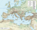
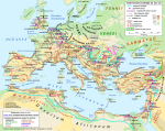
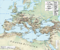
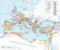
English: Map of the Roman Empire in 125 during the reign of emperor Hadrian, with anachronistic Germanic tribes from the time of Augustus.

Projection

Lambert azimuthal-equal area. Central latitude: 45° N, central longitude: 20° E. X, Y origin offset - 0

Datum: ETRS89

Sources

The physical map was made using the following public domain sources:

Additional references for the map content:

  • Tacitus, Germania (ca. 100)
  • Ptolemy, Geographia (ca. 140)
  • Atlante storico DeAgostini, Instituto Geografico DeAgostini, 1998. pg. 35-41.
  • Historischer Weltatlas, Dr. Walter Leisering, Marix Verlag, 2011. pg. 26-27
  • Történelmi világatlasz, Cartographia Kiadó, 2005. pg. 20-21.
  • The Penguin Historical Atlas of Ancient Rome by Christopher Scarre, Penguin Historical Atlases, 1995. pg. 81.

Software used

GIS:

Graphics editors:

Data
Jatorria Norberak egina
Egilea
Lizentzia
(Fitxategi hau berrerabiltzen)
Any use of this map can be made as long as you credit the author, Andrei N. (Wikipedia Commons user Andrein), and distribute the copies and derivative works under the same license as that the one stated below.
Beste bertsioak [aldatu]
File:Roman Empire 125.svg fitxategi honen bektore bertsioa da. Hau rasterizatutako bertsioaren ordez erabili beharko litzateke hobea izatekotan.

File:Roman Empire 125.png → File:Roman Empire 125.svg

Grafiko bektorialei buruzko informazioa lortzeko, irakurri SVGra trantsizioa Commonsen.
MediaWikiko SVG irudien inguruko laguntza teknikoa ere badago.

Beste hizkuntza batzuetan
Alemannisch  Bahasa Indonesia  Bahasa Melayu  British English  català  čeština  dansk  Deutsch  eesti  English  español  Esperanto  euskara  français  Frysk  galego  hrvatski  Ido  italiano  lietuvių  magyar  Nederlands  norsk bokmål  norsk nynorsk  occitan  Plattdüütsch  polski  português  português do Brasil  română  Scots  sicilianu  slovenčina  slovenščina  suomi  svenska  Tiếng Việt  Türkçe  vèneto  Ελληνικά  беларуская (тарашкевіца)  български  македонски  нохчийн  русский  српски / srpski  татарча/tatarça  українська  ქართული  հայերեն  বাংলা  தமிழ்  മലയാളം  ไทย  한국어  日本語  简体中文  繁體中文  עברית  العربية  فارسی  +/−
SVG irudi berria

General map
Political map

Lizentzia

Nik, lan honen egileak, argitaratzen dut ondorengo lizentzia hauen pean:
w:eu:Creative Commons
eskuduntza berdin partekatu
Fitxategi hau Creative Commons Attribution-Share Alike 3.0 Unported lizentziapean dago.
Askea zara:
  • partekatzeko – lana kopiatzeko, banatzeko eta bidaltzeko
  • birnahasteko – lana moldatzeko
Ondorengo baldintzen pean:
  • eskuduntza – Egiletza behar bezala aitortu behar duzu, lizentzia ikusteko esteka gehitu, eta ea aldaketak egin diren aipatu. Era egokian egin behar duzu hori guztia, baina inola ere ez egileak zure lana edo zure erabilera babesten duela irudikatuz.
  • berdin partekatu – Lan honetan oinarrituta edo aldatuta berria eraikitzen baduzu, emaitza lana hau bezalako lizentzia batekin argitaratu behar duzu.
GNU head Baimena duzu dokumentu hau kopiatu, banatu edo/eta aldatzeko GNU Free Documentation License baldintzapean, Free Software Foundationek argitaratutako 1.2 edo ondorengo bertsioan; sekzio aldaezinik gabe, azaleko testurik gabe, eta atzeko azaleko testurik gabe. Lizentziaren kopia dago GNU Free Documentation License izenburudun atalean.
Nahiago duzun lizentzia erabil dezakezu.
Maps of the history of Europe
BCE
aC

Weichselian ice age (c. 113,000–9700) · Neolithic expansion (c. 7000–4500) · Middle Neolithic (c. 4500–4000) · Late Neolithic (c. 4000–3000) · Copper Age – Corded Ware culture (c. 2900–2350) · Copper Age – Bellbeaker culture (c. 2800–1800) · Early Bronze Age – Unetice culture (c. 2300–1600) · Late Bronze Age – Urnfield culture (c. 1300—750) · Migrations (c. 1000–100) · Hallstatt & La Tène cultures (c. 800–100) · Roman Republic (510–40) · 220 · 218 · 200 · 201–100 · 58 · 49 · 39 · 30 BCE–6 CE


CE
dC

14 · 14–37 · 60 · 60 · 69 · 80 · Migrations 100–500 · 117 · 117 · 125 · Migrations 150–774 · Economy 180 · 271 · 293–305 · 337 · 395 · c. 395 · 400 · 400 · 450 · 457–61 · 476 · 480 · Franks 481–814 · Early Slavs 500–700 · 500 · 526 · 526–600 · Christianisation to 600 · c. 550 · 650 · Pontic Steppe 650 · 665 · 800 · Vikings 800–1050 · 814 · 843–70 · 850 · 900 · 912 · 998 · 1000 · 1000 · 1054 · 1092 · First Crusade 1095–99 · 1097 · 1135 · 1142 · 1147–49 · 1190 · 1190 · 1250 · c. 1250 · 1301-1400 · 1301-1400 · 1328 · 1345 · Black Plague 1347–51 · 1360 · 1400 · Trade routes c. 1400 · 1430 · 1470 · 1490 · 1492 · 1500 · 1519 · 1550 · 1560 · Religion 1560 · Religion 1600 · Religion 1618 · 1618–48 · 1648 · 1683 · 1700 · 1701 · 1708 · 1714 · 1721 · 1725–30 · 1739–1740 · 1740 · 1748–66 · 1783–1792 · 1787 · 1787 · 1789 · 1799 · 1812 · 1812 · 1812 · 1812 · 1813 · 1815 · 1815 · 1815 · 1818 · Ottoman Empire 1830–1923 · 1848–49 · 1861 · 1867 · 1871 · 1878 · 1890 · 1905 · 1911 · 1914 · 1914 · 1919 · 1919–29 · 1923 · 1929 · 1930 · 1940 · 1941–42 · 1942–45 · Cold War 1947–91 · 1950 · 1993–2006 · 2006 to date

(this template: · view · discuss )

Irudi-oineko testuak

Add a one-line explanation of what this file represents
The Roman empire under Hadrian (ruled 117–138) showing the location of roads, cities, provincial boundaries, naval bases, the Roman legions deployed in 125 AD and Germanic tribes from the time of Augustus

Fitxategi honetan agertzen diren itemak

honako hau irudikatzen du

maiatza 2013

45°0'0.000"N, 20°0'0.000"E

media type ingelesa

image/png

Fitxategiaren historia

Data/orduan klik egin fitxategiak orduan zuen itxura ikusteko.

(Azkenekoak | Lehenbizikoak) Ikusi (berriagoak diren 10) () (10 | 20 | 50 | 100 | 250 | 500).
Data/OrduaIruditxoaNeurriakErabiltzaileaIruzkina
oraingoa21:34, 12 urtarrila 201921:34, 12 urtarrila 2019 bertsioaren iruditxoa2.186 × 1.817 (4,43 MB)ArdadNThis purpose of this map is not to represent ancient shorelines. Please upload a separate file with your original contributions!
18:18, 17 iraila 201818:18, 17 iraila 2018 bertsioaren iruditxoa2.186 × 1.817 (4,37 MB)Julieta39Shorelines of the time (Westermann Grosser Atlas zur Weltgeschichte, Braunschweig 1985, p. 36, 38, 39, ISBN 3-14-10-0919-8 and Andrein' s [https://commons.wikimedia.org/wiki/File:Danube_Delta_evolution.gif] since L. Giosan).
20:16, 20 uztaila 201520:16, 20 uztaila 2015 bertsioaren iruditxoa2.186 × 1.817 (4,43 MB)ArdadN1
19:49, 20 uztaila 201519:49, 20 uztaila 2015 bertsioaren iruditxoa2.186 × 1.817 (4,43 MB)ArdadN1
20:47, 3 martxoa 201520:47, 3 martxoa 2015 bertsioaren iruditxoa2.186 × 1.817 (4,43 MB)ArdadNfixing text problems
19:06, 3 martxoa 201519:06, 3 martxoa 2015 bertsioaren iruditxoa2.186 × 1.817 (4,38 MB)ArdadNnew road added
15:26, 10 otsaila 201515:26, 10 otsaila 2015 bertsioaren iruditxoa2.186 × 1.817 (4,43 MB)ArdadN1
20:45, 20 maiatza 201420:45, 20 maiatza 2014 bertsioaren iruditxoa2.186 × 1.817 (4,43 MB)ArdadN1
20:20, 9 apirila 201420:20, 9 apirila 2014 bertsioaren iruditxoa2.186 × 1.817 (4,43 MB)ArdadNScotti
17:39, 30 martxoa 201417:39, 30 martxoa 2014 bertsioaren iruditxoa2.186 × 1.817 (4,43 MB)ArdadN1
(Azkenekoak | Lehenbizikoak) Ikusi (berriagoak diren 10) () (10 | 20 | 50 | 100 | 250 | 500).

Fitxategiaren erabilera orokorra

Hurrengo beste wikiek fitxategi hau darabilte:

Ikus fitxategi honen erabilpen global gehiago.

Metadatuak