
Fitxategi:SyltSat.jpg
Aurreikuspen honen neurria: 445 × 600 pixel. Bestelako bereizmenak: 178 × 240 pixel | 356 × 480 pixel | 668 × 900 pixel.
Bereizmen handikoa ((668 × 900 pixel, fitxategiaren tamaina: 40 KB, MIME mota: image/jpeg))
Fitxategi hau Wikimedia Commonsekoa da. Hango deskribapen orriko informazioa behean duzu. |
Laburpena
| Deskribapena |
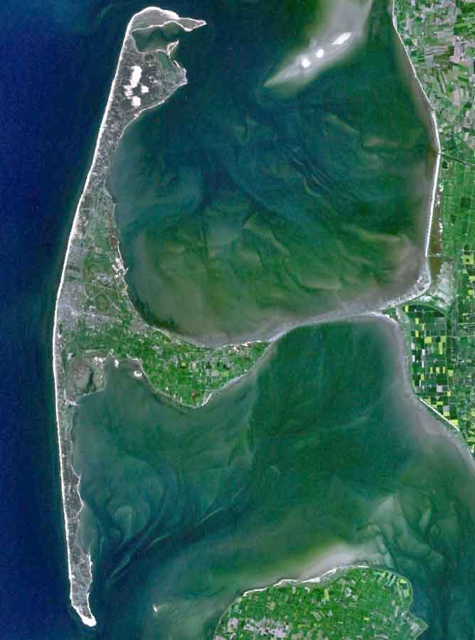
English: The Island of Sylt in Northern Germany from the South. Satellite view. |
| Data | 2005ko apirilaren 24a (igoera data) |
| Jatorria | Satellite imagery taken from NASA World Wind software (by screenshot) |
| Egilea | NASA |
Lizentzia
| This image is in the public domain because it is a screenshot from NASA’s globe software World Wind using a public domain layer, such as Blue Marble, MODIS, Landsat, SRTM, USGS or GLOBE.
|
 |
| Annotations | This image is annotated: View the annotations at Commons |
Fitxategiaren historia
Data/orduan klik egin fitxategiak orduan zuen itxura ikusteko.
| Data/Ordua | Iruditxoa | Neurriak | Erabiltzailea | Iruzkina | |
|---|---|---|---|---|---|
| oraingoa | 21:39, 4 abuztua 2006 | | 668 × 900 (40 KB) | Ollio | original work of NASA - public domain picture made brigther by O. Lippuner (User --~~~~), without changing public domain status |
| 16:01, 24 apirila 2005 |  | 668 × 900 (350 KB) | SeballaOne~commonswiki | The Island of Sylt in Northern Germany from the South. Created with World Wind {{PD-USGov-NASA}} Category:Islands Category:Satellite photos |
Irudira dakarten loturak
Ez dago fitxategi hau darabilen orririk.
Fitxategiaren erabilera orokorra
Hurrengo beste wikiek fitxategi hau darabilte:
- af.wikipedia.org proiektuan duen erabilera
- ar.wikipedia.org proiektuan duen erabilera
- br.wikipedia.org proiektuan duen erabilera
- ca.wikipedia.org proiektuan duen erabilera
- da.wikipedia.org proiektuan duen erabilera
- de.wikipedia.org proiektuan duen erabilera
- en.wikipedia.org proiektuan duen erabilera
- eo.wikipedia.org proiektuan duen erabilera
- es.wikipedia.org proiektuan duen erabilera
- fa.wikipedia.org proiektuan duen erabilera
- frr.wikipedia.org proiektuan duen erabilera
- fr.wikipedia.org proiektuan duen erabilera
- fy.wikipedia.org proiektuan duen erabilera
- is.wikipedia.org proiektuan duen erabilera
- it.wikipedia.org proiektuan duen erabilera
- ko.wikipedia.org proiektuan duen erabilera
- ksh.wikipedia.org proiektuan duen erabilera
- mk.wikipedia.org proiektuan duen erabilera
- nds.wikipedia.org proiektuan duen erabilera
- nn.wikipedia.org proiektuan duen erabilera
- no.wikipedia.org proiektuan duen erabilera
- pnb.wikipedia.org proiektuan duen erabilera
- pt.wikipedia.org proiektuan duen erabilera
- stq.wikipedia.org proiektuan duen erabilera
- sv.wikipedia.org proiektuan duen erabilera
- xmf.wikipedia.org proiektuan duen erabilera
- zh.wikipedia.org proiektuan duen erabilera