
Fitxategi:Syrian, Iraqi, and Lebanese insurgencies.png

Bereizmen handikoa ((4.509 × 3.449 pixel, fitxategiaren tamaina: 1,74 MB, MIME mota: image/png))
Fitxategi hau Wikimedia Commonsekoa da. Hango deskribapen orriko informazioa behean duzu. |
Laburpena

|
This file may be updated to reflect new information. If you wish to use a specific version of the file without new updates being mirrored, please upload the required version as a separate file. |
| Deskribapena |
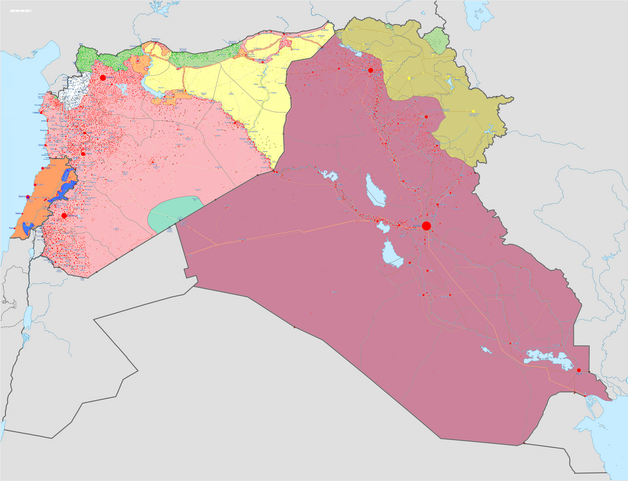
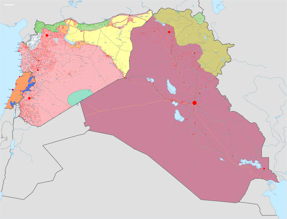
Map of the Syrian Civil War, the Iraq Civil War (2014–present), and the Lebanese insurgency. For previous revisions of the battle map (not including Lebanon) before June 2015, see File:Syria and Iraq 2014-onward War map.png. After updating this map, please also update the date(s) at w:Module:Iraq Syria map date, used to denote the date in articles. Areas under joint SDF-SAA control
In the respective colours: |
||||
| Data | |||||
| Jatorria |
Norberak egina w:en:Template:Syrian, Iraqi, and Lebanese insurgencies detailed map |
||||
| Egilea | BlueHypercane761 | ||||
| Beste bertsioak |
|


.png)


.svg)


.svg)

.svg)


_Territory_Change_2014-2016.gif)

_(within_Northern_Syria).svg)


.png)
.svg)


_map.png)
.svg)


.svg)


|
Irudi hau birsortu beharko litzateke SVG irudi bektorial moduan. Honek abantaila asko ematen ditu, ikus Commons:Media for cleanup (ingelesez) informazio gehiagorako. Irudi honen SVG bertsioa eskuragarri badago, mesedez Commonsera igo. Igo ostean, ordezkatu txantiloi hau txantiloi honegatik {{vector version available|irudiaren izen berria.svg}} irudi honetan.
|

|
This image has a useful history, which can be viewed as an animation. |
Lizentzia
- Askea zara:
- partekatzeko – lana kopiatzeko, banatzeko eta bidaltzeko
- birnahasteko – lana moldatzeko
- Ondorengo baldintzen pean:
- eskuduntza – Egiletza behar bezala aitortu behar duzu, lizentzia ikusteko esteka gehitu, eta ea aldaketak egin diren aipatu. Era egokian egin behar duzu hori guztia, baina inola ere ez egileak zure lana edo zure erabilera babesten duela irudikatuz.
- berdin partekatu – Lan honetan oinarrituta edo aldatuta berria eraikitzen baduzu, emaitza lana hau bezalako lizentzia batekin argitaratu behar duzu.
Fitxategiaren historia
Data/orduan klik egin fitxategiak orduan zuen itxura ikusteko.
| Data/Ordua | Iruditxoa | Neurriak | Erabiltzailea | Iruzkina | |
|---|---|---|---|---|---|
| oraingoa | 13:43, 6 iraila 2020 | | 4.509 × 3.449 (1,74 MB) | LyriaSiders | Reports that the SAA have taken over the Doubayat oil and gas field and surrounding area from ISIL elements. Now there is apparently no more hard control by ISIL in the central desert. |
| 17:10, 24 maiatza 2020 |  | 4.509 × 3.449 (2,21 MB) | Wiz9999 | Updating Revolutionary Commando Army & US presence colour to teal. | |
| 13:27, 7 martxoa 2020 |  | 4.509 × 3.449 (1,74 MB) | Nate Hooper | Update after the Turkish response. Also, see the discussion page for a further update I have planned. | |
| 05:23, 19 otsaila 2020 |  | 4.509 × 3.449 (1,75 MB) | Nate Hooper | Update after the Idlib offensive. | |
| 01:45, 8 otsaila 2020 |  | 4.509 × 3.449 (1,75 MB) | The Dolly Parton Challenge - Still more country than Alan Jackson | Further SAA advances towards Idlib. | |
| 01:26, 8 otsaila 2020 |  | 4.509 × 3.449 (2,51 MB) | The Dolly Parton Challenge - Still more country than Alan Jackson | Reverted to version as of 00:25, 6 February 2020 (UTC) Never mind | |
| 02:32, 6 otsaila 2020 |  | 4.509 × 3.449 (2,51 MB) | TheHatingNerdino666 | Fixed the Manbij area. | |
| 02:25, 6 otsaila 2020 |  | 4.509 × 3.449 (2,51 MB) | TheHatingNerdino666 | Big update as the Syrian Army continues the push towards Idlib. | |
| 19:05, 7 urtarrila 2020 |  | 4.509 × 3.449 (2,27 MB) | Nate Hooper | Wew, it's been a while (I was a way for a bit because I was banned, but I appealed and was successful). Anyway, the SAA have made advances in Idlib. | |
| 19:05, 27 urria 2019 |  | 4.509 × 3.449 (2,51 MB) | Mlpwtfisthat Backup 7.0 | Remove the date. |
Irudira dakarten loturak
Ez dago fitxategi hau darabilen orririk.
Fitxategiaren erabilera orokorra
Hurrengo beste wikiek fitxategi hau darabilte:
- ar.wikipedia.org proiektuan duen erabilera
- arz.wikipedia.org proiektuan duen erabilera
- de.wikipedia.org proiektuan duen erabilera
- en.wikipedia.org proiektuan duen erabilera
- Template talk:Lebanese insurgency detailed map
- Module talk:Syrian, Iraqi, and Lebanese insurgencies detailed map
- Module talk:Syrian and Iraqi insurgency detailed map/Archive 1
- Module talk:Iraqi insurgency detailed map/Archive 4
- Talk:Control of cities during the Syrian civil war/Archive 49
- User:AH bharara/sandbox/Islamic State of Iraq and the Levant affiliated Groups
- Talk:Islamic State/Archive 38
- Wikipedia:Graphics Lab/Map workshop/Archive/2016
- Talk:Islamic State/Archive 40
- Talk:Battle of Mosul (2016–2017)/Archive 1
- Talk:Islamic State/Archive 41
- User:KaldeFakta68/sandbox
- User:Edisonabcd/sandbox
- fa.wikipedia.org proiektuan duen erabilera
- fr.wikipedia.org proiektuan duen erabilera
- id.wikipedia.org proiektuan duen erabilera
- ku.wikipedia.org proiektuan duen erabilera
- mi.wikipedia.org proiektuan duen erabilera
- pt.wikinews.org proiektuan duen erabilera
- tr.wikipedia.org proiektuan duen erabilera
- www.wikidata.org proiektuan duen erabilera
- zh.wikipedia.org proiektuan duen erabilera