
Fitxategi:Tambora EFS highres STS049 STS049-97-54.jpg
Aurreikuspen honen neurria: 596 × 599 pixel. Bestelako bereizmenak: 239 × 240 pixel | 477 × 480 pixel | 764 × 768 pixel | 1.018 × 1.024 pixel | 2.037 × 2.048 pixel | 3.940 × 3.962 pixel.
Bereizmen handikoa ((3.940 × 3.962 pixel, fitxategiaren tamaina: 2,61 MB, MIME mota: image/jpeg))
Fitxategi hau Wikimedia Commonsekoa da. Hango deskribapen orriko informazioa behean duzu. |
Laburpena
| Deskribapena |
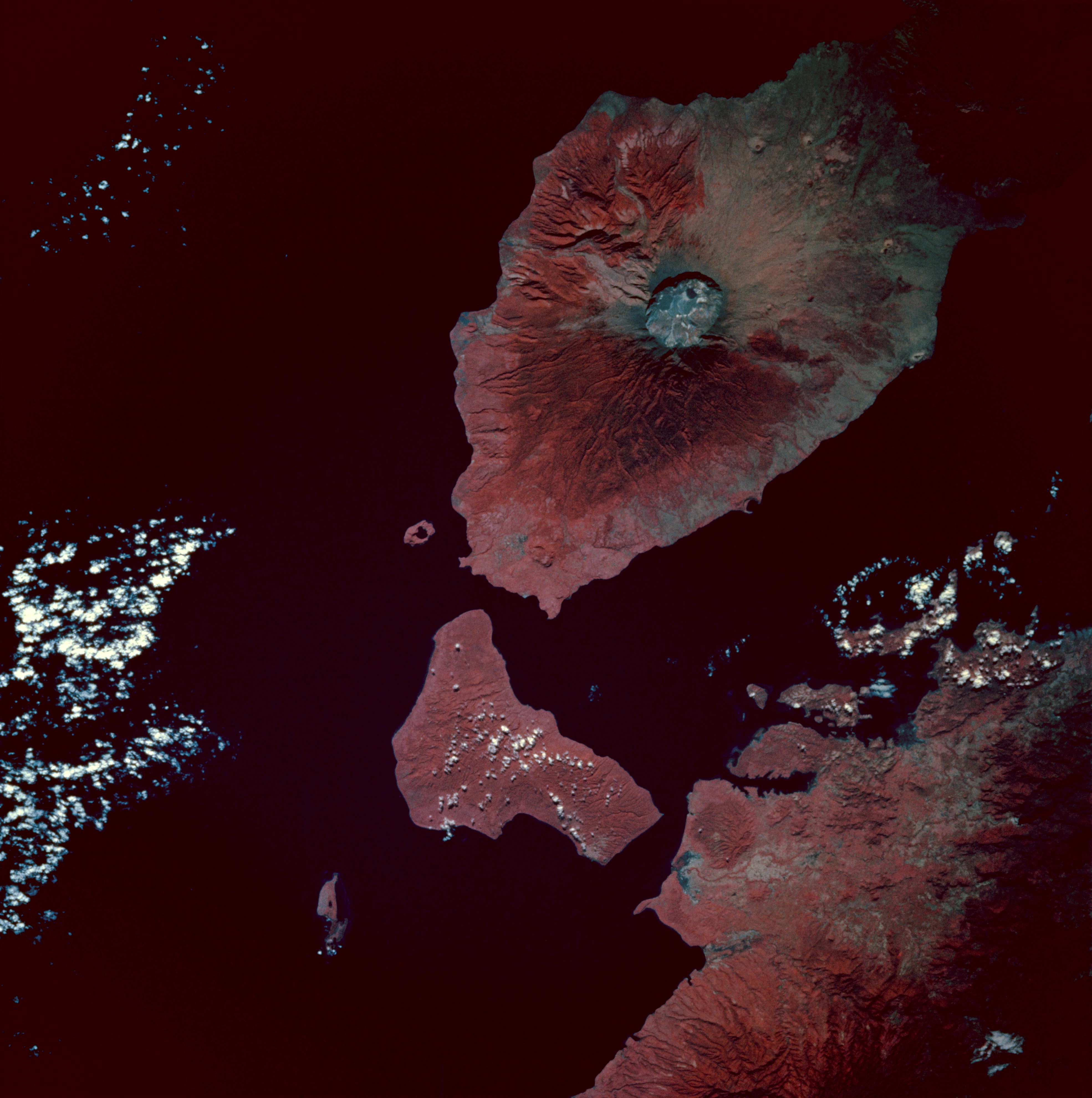
Infrared image of Mount Tambora, Sumbawa Island, Indonesia. Taken from the space shuttle Endeavour at 0:54 GMT on 13 May 1992.
|
| Data | |
| Jatorria | [2] |
| Egilea | Image Science and Analysis Laboratory, NASA-Johnson Space Center. "The Gateway to Astronaut Photography of Earth". |
Lizentzia
| This file is in the public domain in the United States because it was solely created by NASA. NASA copyright policy states that "NASA material is not protected by copyright unless noted". (See Template:PD-USGov, NASA copyright policy page or JPL Image Use Policy.) | ||
 |
Warnings:
|
Fitxategiaren historia
Data/orduan klik egin fitxategiak orduan zuen itxura ikusteko.
| Data/Ordua | Iruditxoa | Neurriak | Erabiltzailea | Iruzkina | |
|---|---|---|---|---|---|
| oraingoa | 10:49, 8 otsaila 2010 | | 3.940 × 3.962 (2,61 MB) | Avenue | {{Information |Description=Infrared image of Mount Tambora, Sumbawa Island, Indonesia. Taken from the space shuttle Endeavour at 0:54 GMT on 13 May 1992. <br/>Description from [http://city.jsc.nasa.gov/sseop/EFS/photoinfo.pl?PHOTO=STS049-97-54]:<br/> The |
Irudira dakarten loturak
Ez dago fitxategi hau darabilen orririk.
Fitxategiaren erabilera orokorra
Hurrengo beste wikiek fitxategi hau darabilte:
- ar.wikipedia.org proiektuan duen erabilera
- ast.wikipedia.org proiektuan duen erabilera
- bn.wikipedia.org proiektuan duen erabilera
- br.wikipedia.org proiektuan duen erabilera
- el.wikipedia.org proiektuan duen erabilera
- en.wikipedia.org proiektuan duen erabilera
- es.wikipedia.org proiektuan duen erabilera
- id.wikipedia.org proiektuan duen erabilera
- mk.wikipedia.org proiektuan duen erabilera
- ms.wikipedia.org proiektuan duen erabilera
- pt.wikipedia.org proiektuan duen erabilera
- ro.wikipedia.org proiektuan duen erabilera
- tr.wikipedia.org proiektuan duen erabilera
- Tambora Dağı
- 1815 Tambora Dağı patlaması
- Kullanıcı:Anerka/Takip/Biliyor muydunuz?
- Kullanıcı:LostMyMind/BM logları
- Vikipedi:Biliyor muydunuz?/Arşiv/2022+
- Vikipedi:Biliyor muydunuz?/2023-03-05
- Vikipedi:Biliyor muydunuz/Mart 2023
- Vikipedi:Biliyor muydunuz/Şubat 2024
- Vikipedi:Biliyor muydunuz?/2024-02-13
- zh.wikipedia.org proiektuan duen erabilera