
Fitxategi:U-Bahn Wien, Netzplan.svg

SVG fitxategi honen PNG aurreikuspenaren tamaina: 637 × 600 pixel. Bestelako bereizmenak: 255 × 240 pixel | 510 × 480 pixel | 816 × 768 pixel | 1.088 × 1.024 pixel | 2.176 × 2.048 pixel | 835 × 786 pixel.
Bereizmen handikoa (SVG fitxategia, nominaldi 835 × 786 pixel, fitxategiaren tamaina: 152 KB)
Fitxategi hau Wikimedia Commonsekoa da. Hango deskribapen orriko informazioa behean duzu. |
Laburpena
| Deskribapena |
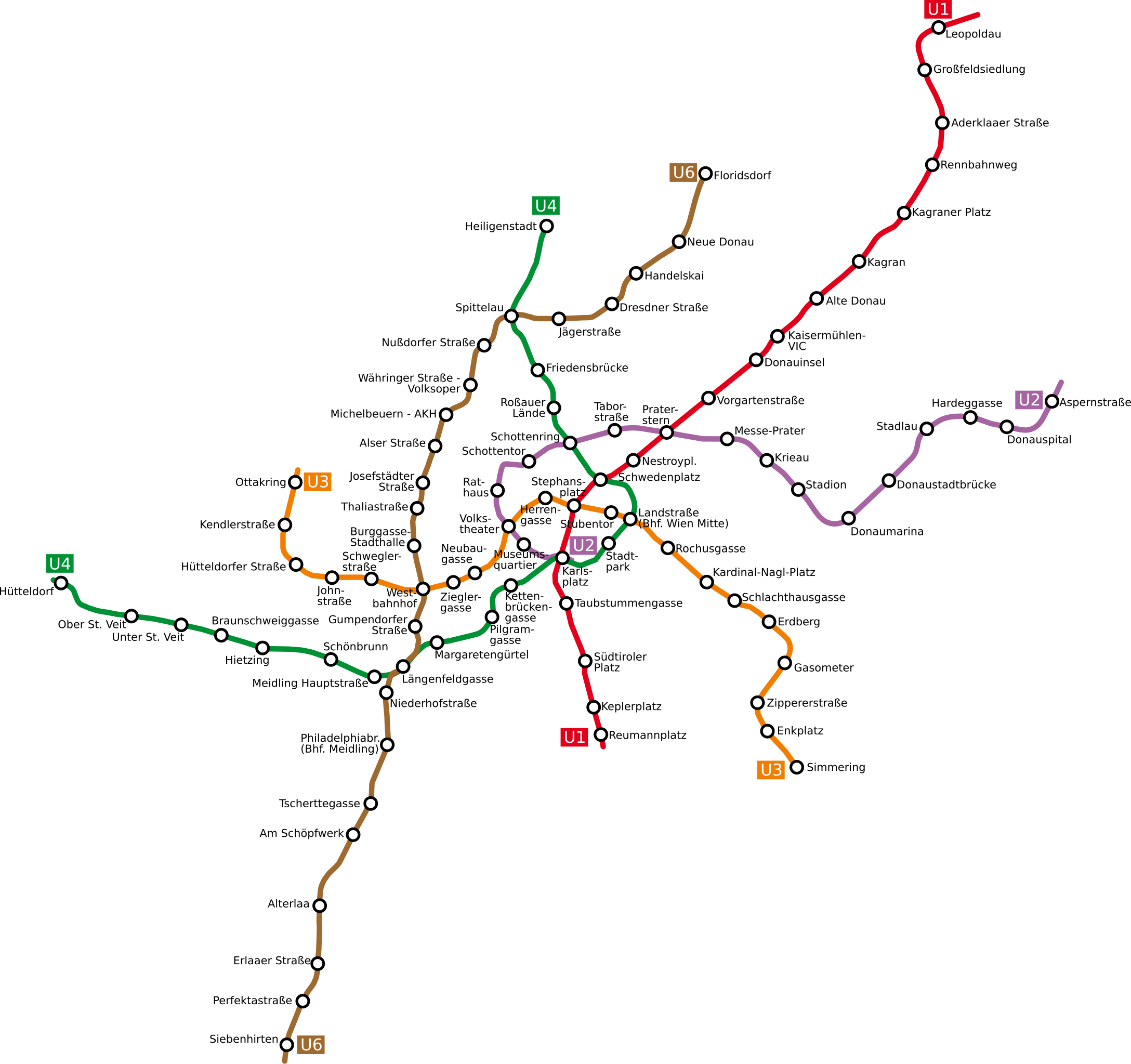
Deutsch: Netzplan der Wiener U-Bahn
English: The underground network of the Austrian capital Vienna
Esperanto: La metroreto de la Aŭstruja ĉefurbo Vieno
Polski: Plan wiedeńskiego metra |
| Data | |
| Jatorria | http://www.openstreetmap.org/browse/relation/27116 |
| Egilea | OpenStreetMap contributors, Ircecho |
| SVG genesis | Fitxategi hau (bektore-irudia) hau Inkscape-ekin sortu da .
, or with something else. |
Lizentzia
Nik, lan honen egileak, argitaratzen dut ondorengo lizentzia pean:
This file is licensed under the Creative Commons Attribution-Share Alike 2.0 Generic license.
- Askea zara:
- partekatzeko – lana kopiatzeko, banatzeko eta bidaltzeko
- birnahasteko – lana moldatzeko
- Ondorengo baldintzen pean:
- eskuduntza – Egiletza behar bezala aitortu behar duzu, lizentzia ikusteko esteka gehitu, eta ea aldaketak egin diren aipatu. Era egokian egin behar duzu hori guztia, baina inola ere ez egileak zure lana edo zure erabilera babesten duela irudikatuz.
- berdin partekatu – Lan honetan oinarrituta edo aldatuta berria eraikitzen baduzu, emaitza lana hau bezalako lizentzia batekin argitaratu behar duzu.
Fitxategiaren historia
Data/orduan klik egin fitxategiak orduan zuen itxura ikusteko.
| Data/Ordua | Iruditxoa | Neurriak | Erabiltzailea | Iruzkina | |
|---|---|---|---|---|---|
| oraingoa | 17:07, 12 apirila 2011 | | 835 × 786 (152 KB) | Ircecho | I now improved readability. Additionally i removed the city border as to make the update just an update. As based on my research i think the old plan is incorrect, its in my opinion right to overwrite it with this redo. |
| 16:30, 8 apirila 2011 |  | 1.063 × 1.020 (136 KB) | Invisigoth67 | Reverted to version as of 18:54, 30 March 2011: Please do not overwrite with a complete new plan, use an new filename instead. This version is much better readable than the new layout. | |
| 20:28, 4 apirila 2011 |  | 1.488 × 1.052 (271 KB) | Ircecho | Redid the whole plan. | |
| 20:54, 30 martxoa 2011 |  | 1.063 × 1.020 (136 KB) | Ircecho | Extended the map to include the expansion state of 2011. Track and station positions are based on openstreetmap data, which was aligned to stations Donauinsel, Vorgartenstrasse, Krieau, Kardinal-Nagl-Platz and Schlachthausgasse. Stadion was moved a bit, f | |
| 19:44, 11 maiatza 2008 |  | 982 × 1.031 (132 KB) | Aldaron | == Summary == {{Information |Description=*de: Netzplan der Wiener U-Bahn *en: The underground network of the Austrian capital Vienna |Source= |Date=2007 |Author=Based on original upload by L.m.k |Permission= |other_versions= }} | |
| 13:19, 13 martxoa 2007 |  | 982 × 1.031 (127 KB) | Hukkepakk | == Summary == {{Information |Description=*[:de:]] Netzplan der Wiener U-Bahn *en: The underground network of the Austrian capital Vienna.}} |Source= |Date=2007 |Author=L.m.k |Permission= |other_versions= }} == Licensing == {{self2|GFD |
Irudira dakarten loturak
Ez dago fitxategi hau darabilen orririk.
Fitxategiaren erabilera orokorra
Hurrengo beste wikiek fitxategi hau darabilte:
- ca.wikipedia.org proiektuan duen erabilera
- da.wikipedia.org proiektuan duen erabilera
- de.wikipedia.org proiektuan duen erabilera
- eo.wikipedia.org proiektuan duen erabilera
- ro.wikipedia.org proiektuan duen erabilera
- ru.wikivoyage.org proiektuan duen erabilera
- sk.wikipedia.org proiektuan duen erabilera