
Fitxategi:US Virgin Islands admin divisions.png
Aurreikuspen honen neurria: 800 × 486 pixel. Bestelako bereizmenak: 320 × 194 pixel | 640 × 389 pixel | 1.022 × 621 pixel.
Bereizmen handikoa ((1.022 × 621 pixel, fitxategiaren tamaina: 33 KB, MIME mota: image/png))
Fitxategi hau Wikimedia Commonsekoa da. Hango deskribapen orriko informazioa behean duzu. |

|
This map has been uploaded by Electionworld from en.wikipedia.org to enable the |
Laburpena
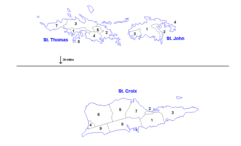
Administrative divisions of the U.S. Virgin Islands. Created by Rarelibra 16:11, 31 March 2006 (UTC) for public domain use. Created using MapInfo Professional v7.5 and vairous mapping resources.
| Districts | Saint Thomas | Saint John | Saint Croix |
|---|---|---|---|
| Sub-districts |
|
|
|
Lizentzia
| Nik, lan honen egile eskubideen jabeak, lan hau domeinu publikoan jartzen dut. Mundu osoan du eragina honek. Estatu batzuetan beharbada hori ez da legez posible izango. Halakoetan: Edonori ematen diot lan hau edozertarako erabiltzeko eskubidea, inolako baldintzarik gabe, legeak nahitaez ezarritako baldintzak izan ezik. |
Fitxategiaren historia
Data/orduan klik egin fitxategiak orduan zuen itxura ikusteko.
| Data/Ordua | Iruditxoa | Neurriak | Erabiltzailea | Iruzkina | |
|---|---|---|---|---|---|
| oraingoa | 15:57, 19 martxoa 2014 | | 1.022 × 621 (33 KB) | Ahnoneemoos | removing border |
| 15:55, 19 martxoa 2014 |  | 1.022 × 621 (33 KB) | Ahnoneemoos | removing border | |
| 22:31, 27 azaroa 2006 |  | 1.025 × 624 (15 KB) | Electionworld | {{ew|en|Rarelibra}} == Summary == Administrative divisions (districts and sub-districts) of the U.S. Virgin Islands. Created by Rarelibra 16:11, 31 March 2006 (UTC) for public domain use. Created using MapInfo Professional v7.5 and |
Irudira dakarten loturak
Hurrengo orrialdeek dute fitxategi honetarako lotura:
Fitxategiaren erabilera orokorra
Hurrengo beste wikiek fitxategi hau darabilte:
- ast.wikipedia.org proiektuan duen erabilera
- en.wikipedia.org proiektuan duen erabilera
- gl.wikipedia.org proiektuan duen erabilera
- li.wikipedia.org proiektuan duen erabilera
- mk.wikipedia.org proiektuan duen erabilera
- ml.wikipedia.org proiektuan duen erabilera
- nn.wikipedia.org proiektuan duen erabilera
- no.wikipedia.org proiektuan duen erabilera
- os.wikipedia.org proiektuan duen erabilera
- sr.wikipedia.org proiektuan duen erabilera
- ta.wikipedia.org proiektuan duen erabilera
- uk.wikipedia.org proiektuan duen erabilera
- vi.wikipedia.org proiektuan duen erabilera
- www.wikidata.org proiektuan duen erabilera