
Fitxategi:View of Amsterdam.JPG
Bereizmen handikoa ((3.341 × 2.431 pixel, fitxategiaren tamaina: 3,18 MB, MIME mota: image/jpeg))
Fitxategi hau Wikimedia Commonsekoa da. Hango deskribapen orriko informazioa behean duzu. |
Laburpena
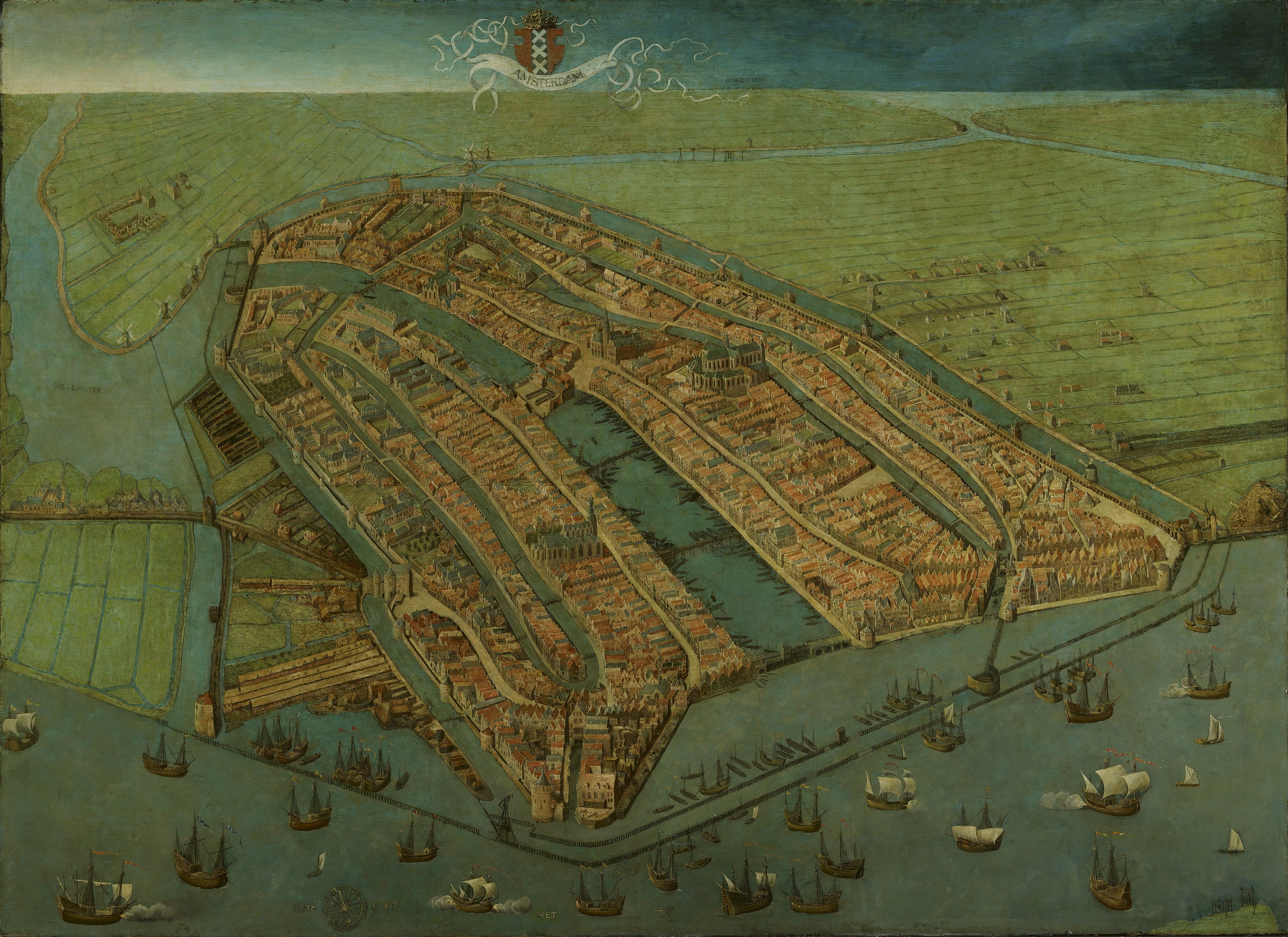
| Cornelis Anthonisz.: Bird’s-eye View of Amsterdam
|
|||||||||||||||||||||||||||
|---|---|---|---|---|---|---|---|---|---|---|---|---|---|---|---|---|---|---|---|---|---|---|---|---|---|---|---|
| Artista |
|
 | |||||||||||||||||||||||||
| Izenburua |
ingelesa:
Bird's-eye view of Amsterdam |
||||||||||||||||||||||||||
| Object type | margolan | ||||||||||||||||||||||||||
| Genero |
hiri-paisaia |
||||||||||||||||||||||||||
| Deskribapena |
Oldest surviving map of Amsterdam, showing the city's finished medieval walls, towers and gates. Like in most old maps of Amsterdam the city is shown from the IJ, so that the view is directed to the south rather than the north. |
||||||||||||||||||||||||||
| Data |
1538 / 1530 - 1539 |
||||||||||||||||||||||||||
| Teknika |
oil on panel |
||||||||||||||||||||||||||
| Neurriak |
altuera: 116 cm |
||||||||||||||||||||||||||
| Bilduma |
|
||||||||||||||||||||||||||
| Erregistro-zenbakia |
SA 3009 |
||||||||||||||||||||||||||
| Place of creation | Amsterdam | ||||||||||||||||||||||||||
| Object history |
1538: commissioned by the city of Amsterdam (?) by 1667: Kamer van de Thesauriers Ordinaris, New town hall, Amsterdam Data ezezaguna: transferred to Amsterdam Museum, Inventory number SA 3009, Amsterdam |
||||||||||||||||||||||||||
| Exhibition history | Het Aanzien van Amsterdam. Panorama's, plattegronden en profielen uit de Gouden Eeuw, Stadsarchief Amsterdam, Amsterdam, 2007ko urriaren 19a–2008ko urtarrilaren 16a, ISBN 978-90-6868-444-5, p. 86-87, kat. no. 3, with color image, as Gezicht in vogelvlucht op Amsterdam, 1538. | ||||||||||||||||||||||||||
| Inscriptions |
Izenburua : AMSTERDAM
: AMSTELVEEN
: HET [-] TY
Data eta monogram : 153[8] [-] CAT
|
||||||||||||||||||||||||||
| Aipuak |
|
||||||||||||||||||||||||||
| Jatorria/Argazkilaria | www.amsterdammuseum.nl : Home : Info, het Amsterdam Museum [1] | ||||||||||||||||||||||||||
| Beste bertsioak |
|
||||||||||||||||||||||||||
.jpg)

_by_Cornelis_Anthonisz.jpg)

Lizentzia
|
Honoko hau, domeinu publikoan dagoen bi dimentsioko artelan baten argazki-erreprodukzio fidela da. Artelana domeinu publikoan dago ondoko arrazoi hauengatik:
Wikimedia Fundazioak duen jarrera ofiziala hau da:«domeinu publikoan dauden bi dimentsioko erreprodukzio fidelak domeinu publikokoak dira.»
Argazki-erreprodukzio hau, beraz, domeinu publikokotzat hartzen da Estatu Batuetan. Beste jurisdikzio batzuetan eduki honen berrerabilera mugatua egon liteke; xehetasunetarako, ikus Reuse of PD-Art photographs. | ||||
Fitxategiaren historia
Data/orduan klik egin fitxategiak orduan zuen itxura ikusteko.
| Data/Ordua | Iruditxoa | Neurriak | Erabiltzailea | Iruzkina | |
|---|---|---|---|---|---|
| oraingoa | 14:50, 11 apirila 2023 | | 3.341 × 2.431 (3,18 MB) | Vincent Steenberg | rotated 0.5° AC, cropped |
| 21:34, 6 apirila 2023 |  | 3.484 × 2.518 (9,62 MB) | Artanisen | Higher quality - https://hart.amsterdam/nl/collectie/object/amcollect/38011 | |
| 12:19, 17 abendua 2010 |  | 6.400 × 4.650 (1,94 MB) | Maarten Jansen | {{Information |Description={{en|1=Oldest surviving plan of the medieval town of Amsterdam }} {{nl|1=Oudste nog bestaande plattegrond van middeleeuws Amsterdam}} |Source={{[http://ahm.adlibsoft.com/ahmonline/dispatcher.aspx?action=search&database=ChoiceCol |
Irudira dakarten loturak
Hurrengo orrialdeek dute fitxategi honetarako lotura:
Fitxategiaren erabilera orokorra
Hurrengo beste wikiek fitxategi hau darabilte:
- af.wikipedia.org proiektuan duen erabilera
- ar.wikipedia.org proiektuan duen erabilera
- br.wikipedia.org proiektuan duen erabilera
- bs.wikipedia.org proiektuan duen erabilera
- ca.wikipedia.org proiektuan duen erabilera
- cs.wikipedia.org proiektuan duen erabilera
- de.wikipedia.org proiektuan duen erabilera
- en.wikipedia.org proiektuan duen erabilera
- et.wikipedia.org proiektuan duen erabilera
- fi.wikipedia.org proiektuan duen erabilera
- fr.wikipedia.org proiektuan duen erabilera
- is.wikipedia.org proiektuan duen erabilera
- it.wikipedia.org proiektuan duen erabilera
- it.wikivoyage.org proiektuan duen erabilera
- ja.wikipedia.org proiektuan duen erabilera
- nl.wikipedia.org proiektuan duen erabilera
- pt.wikipedia.org proiektuan duen erabilera
- ru.wikipedia.org proiektuan duen erabilera
- sh.wikipedia.org proiektuan duen erabilera
- sr.wikipedia.org proiektuan duen erabilera
- tr.wikipedia.org proiektuan duen erabilera
- uk.wikipedia.org proiektuan duen erabilera
- www.wikidata.org proiektuan duen erabilera