
Fitxategi:Wales Monmouthshire locator map.svg

SVG fitxategi honen PNG aurreikuspenaren tamaina: 502 × 600 pixel. Bestelako bereizmenak: 201 × 240 pixel | 402 × 480 pixel | 643 × 768 pixel | 857 × 1.024 pixel | 1.714 × 2.048 pixel | 1.047 × 1.251 pixel.
Bereizmen handikoa (SVG fitxategia, nominaldi 1.047 × 1.251 pixel, fitxategiaren tamaina: 149 KB)
Fitxategi hau Wikimedia Commonsekoa da. Hango deskribapen orriko informazioa behean duzu. |
Laburpena
| Deskribapena |
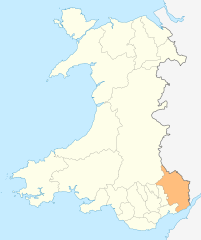
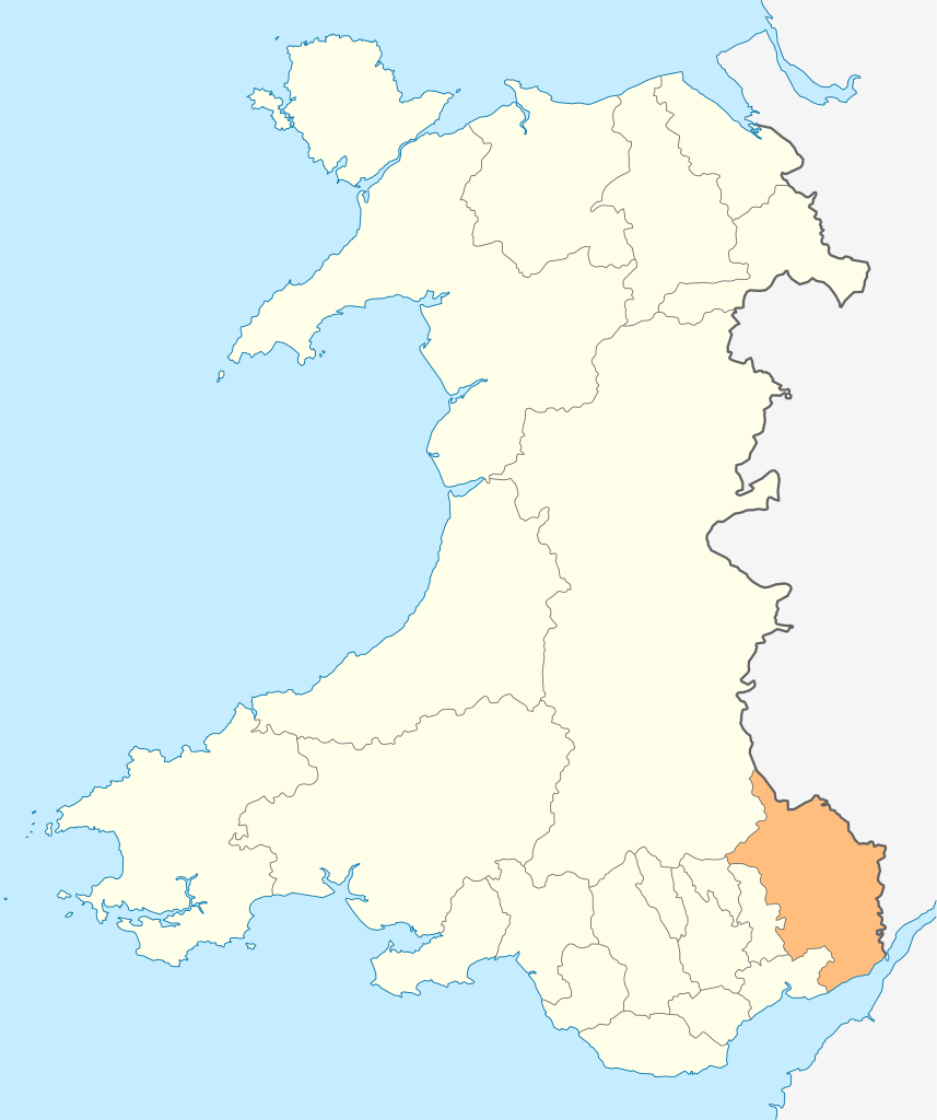
Deutsch: Lagekarte von Monmouthshire in Wales
English: Locator map of Monmouthshire in Wales |
| Data | |
| Jatorria | Norberak egina |
| Egilea | NordNordWest |
| Lizentzia (Fitxategi hau berrerabiltzen) |
Nik, lan honen egileak, argitaratzen dut ondorengo lizentzia pean: Fitxategi hau Creative Commons Attribution-Share Alike 3.0 Unported lizentziapean dago.
|

|
This map has been made or improved in the German Kartenwerkstatt (Map Lab). You can propose maps to improve as well.
|
Fitxategiaren historia
Data/orduan klik egin fitxategiak orduan zuen itxura ikusteko.
| Data/Ordua | Iruditxoa | Neurriak | Erabiltzailea | Iruzkina | |
|---|---|---|---|---|---|
| oraingoa | 20:54, 4 maiatza 2010 | | 1.047 × 1.251 (149 KB) | NordNordWest | {{int:filedesc}} {{Information |Description= {{de|Lagekarte von Monmouthshire in Wales}} {{en|Locator map of Monmouthshire in Wales}} |Source={{Own}} |Date=2010-05-04 |Author={{U|NordNordWest}} |Permission={{self|cc-by-sa-3.0}} |other_versions= }} {{Kart |
Irudira dakarten loturak
100 orrik baino gehiagok darabilte fitxategi hau. Ondorengo zerrendan, fitxategi hau darabilten lehen 100 orriak besterik ez da ageri. Ikusgai duzu zerrenda osoa ere.
- Aberffrwd (Monmouthshire)
- Abergavenny
- Bedwellty
- Bettws Newydd
- Botany Bay (Monmouthshire)
- Bryngwyn
- Buckholt (Monmouthshire)
- Caer Llan
- Caerwent
- Caldicot (Monmouthshire)
- Catbrook
- Chepstow
- Clydach (Monmouthshire)
- Clytha
- Coed-y-paen
- Coed Morgan
- Crick (Monmouthshire)
- Cross Ash
- Crossway (Monmouthshire)
- Cwmcarvan
- Cwmyoy
- Devauden
- Dingestow
- Dixton
- Earlswood (Monmouthshire)
- Gaerllwyd
- Gilwern
- Glascoed
- Govilon
- Goytre (Monmouthshire)
- Grosmont (Monmouthshire)
- Gwehelog
- Gwernesney
- Itton
- Kemeys Commander
- Kilgwrrwg
- Little Mill (Monmouthshire)
- Llanarth (Monmouthshire)
- Llanbadoc
- Llancayo
- Llanddewi Rhydderch
- Llanddewi Skirrid
- Llanddyfrwyr-yn-Edeligion
- Llandegveth
- Llandenny
- Llandogo
- Llanellen
- Llanelly
- Llanfair Kilgeddin
- Llanfoist
- Llangattock-Vibon-Avel
- Llangattock Lingoed
- Llangovan
- Llangua
- Llangwm (Monmouthshire)
- Llangybi (Monmouthshire)
- Llanhennock
- Llanishen (Monmouthshire)
- Llanllowell
- Llanover
- Llansoy
- Llanthony
- Llantilio Crossenny
- Llantilio Pertholey
- Llantrisant (Monmouthshire)
- Llanvair Discoed
- Llanvapley
- Llanvetherine
- Llanvihangel-Ystern-Llewern
- Llanvihangel Crucorney
- Llanvihangel Gobion
- Llanwenarth
- Magor (Monmouthshire)
- Mamhilad
- Mardy (Monmouthshire)
- Maryland (Monmouthshire)
- Mathern
- Mitchel Troy
- Monkswood (Monmouthshire)
- Monmouth
- Mounton
- Nant-y-derry
- Newbridge-on-Usk
- Newcastle (Monmouthshire)
- Newchurch (Monmouthshire)
- Oldcastle (Monmouthshire)
- Pandy (Monmouthshire)
- Pen-y-cae-mawr
- Pen-y-clawdd
- Penallt
- Penpergwm
- Portskewett
- Rogiet
- Tintern
- Usk
- Whitebrook
- Wolvesnewton
- Wonastow
- Wyesham
- Lankide:Euskaldunaa
Ikusi fitxategi honen lotura gehiago.
Fitxategiaren erabilera orokorra
Hurrengo beste wikiek fitxategi hau darabilte:
- cs.wikipedia.org proiektuan duen erabilera
- en.wikipedia.org proiektuan duen erabilera
- Abergavenny
- Monmouth
- Usk
- Chepstow
- Monmouthshire
- Caldicot
- Caerwent
- Llanelly
- Rogiet
- List of places in Monmouthshire
- Little Mill, Monmouthshire
- Template:Monmouthshire-geo-stub
- Llanbadoc
- Wye Valley
- River Trothy
- Llanarth, Monmouthshire
- Grosmont, Monmouthshire
- Graig Syfyrddin
- Monnow Valley Walk
- Tregare
- Blaina
- Llanddewi Rhydderch
- Ashvale, Blaenau Gwent
- Govilon
- Llantilio Pertholey
- Llanvihangel Gobion
- Llangattock Lingoed
- Llanvihangel-Ystern-Llewern
- Cross Ash
- Bryngwyn
- Cwmcarvan
- Mitchel Troy
- Newbridge-on-Usk
- Mardy, Monmouthshire
- Wolvesnewton
- Llanover
- Llancayo
- Llandenny
- Llanvetherine
- Mamhilad
- Oldcastle, Monmouthshire
- Llantrisant, Monmouthshire
- Llanwenarth
- St. Arvans
- Catbrook
- Glascoed
- Llansoy
- St. Maughans
- Monkswood, Monmouthshire
Ikus fitxategi honen erabilpen global gehiago.