Edukira joan

Fitxategi:Map en county of Toulouse 1154.jpg

Orriaren edukia ez da onartzen beste hizkuntza batzuetan.
Wikipedia, Entziklopedia askea

Map_en_county_of_Toulouse_1154.jpg((394 × 293 pixel, fitxategiaren tamaina: 74 KB, MIME mota: image/jpeg))

Fitxategi hau Wikimedia Commonsekoa da. Hango deskribapen orriko informazioa behean duzu.
Commons gordailu bat da, lizentzia askea duten multimedia fitxategiena. Lagun dezakezu.

Fitxategi hau Wikimedia Commonsekoa da

Laburpena

Deskribapena
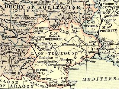
English: Map of County of Toulouse in 1154.
Français : Carte du comté de Toulouse en 1154.
Jatorria
English: This map come from the map collection of University of Texas, specifically from: France, 1154-1184, from Historical Atlas by William R. Shepherd, 1911.. It is in the public domain (http://www.lib.utexas.edu/maps/faq.html#3.html).
Français : Cette carte est issue issu de la collection de cartes de l'université du Texas et plus précisément de celle-ci : France, 1154-1184, from Historical Atlas by William R. Shepherd, 1911.. Elle se trouve dans dans le domaine public (http://www.lib.utexas.edu/maps/faq.html#3.html).
Nederlands: Deze afbeelding is afkomstig uit de kaartencollectie van de University of Texas. Deze kaarten bevinden zich in het publiek domein (http://www.lib.utexas.edu/maps/faq.html#3.html).
Public domain

Lan hau jabetza publikoan dago bai bere jatorrizko herrialdean, bai egile eskubideak egilea hil eta 70 urtera edo gutxiagora iraungitzen diren gainerako herrialdeetan.


You must also include a United States public domain tag to indicate why this work is in the public domain in the United States. Note that a few countries have copyright terms longer than 70 years: Mexico has 100 years, Jamaica has 95 years, Colombia has 80 years, and Guatemala and Samoa have 75 years. This image may not be in the public domain in these countries, which moreover do not implement the rule of the shorter term. Honduras has a general copyright term of 75 years, but it does implement the rule of the shorter term. Copyright may extend on works created by French who died for France in World War II (more information), Russians who served in the Eastern Front of World War II (known as the Great Patriotic War in Russia) and posthumously rehabilitated victims of Soviet repressions (more information).

Egilea
William Robert Shepherd  (1871–1934)  wikidata:Q8017647 s:en:Author:William Robert Shepherd
 
Bestelako izenak
William R. Shepherd; William Shepherd
Deskribapena kartografo eta historialari US
Jaiotza/heriotza data 1871ko ekainaren 12a Edit this at Wikidata 1934ko ekainaren 7a Edit this at Wikidata
Jaiotza/heriotza lekua Charleston Berlin
Lan egindako lekua
Autoritateen kontrol
creator QS:P170,Q8017647

Lizentzia

Public domain

Lan hau jabetza publikoan dago bai bere jatorrizko herrialdean, bai egile eskubideak egilea hil eta 70 urtera edo gutxiagora iraungitzen diren gainerako herrialdeetan.


You must also include a United States public domain tag to indicate why this work is in the public domain in the United States. Note that a few countries have copyright terms longer than 70 years: Mexico has 100 years, Jamaica has 95 years, Colombia has 80 years, and Guatemala and Samoa have 75 years. This image may not be in the public domain in these countries, which moreover do not implement the rule of the shorter term. Honduras has a general copyright term of 75 years, but it does implement the rule of the shorter term. Copyright may extend on works created by French who died for France in World War II (more information), Russians who served in the Eastern Front of World War II (known as the Great Patriotic War in Russia) and posthumously rehabilitated victims of Soviet repressions (more information).

Irudi-oineko testuak

Add a one-line explanation of what this file represents

Fitxategi honetan agertzen diren itemak

honako hau irudikatzen du

media type ingelesa

image/jpeg

Fitxategiaren historia

Data/orduan klik egin fitxategiak orduan zuen itxura ikusteko.

Data/OrduaIruditxoaNeurriakErabiltzaileaIruzkina
oraingoa20:32, 26 azaroa 200820:32, 26 azaroa 2008 bertsioaren iruditxoa394 × 293 (74 KB)Odejea{{Information |Description={{en|1=Map of County of Toulouse in 1154.}} {{fr|1=Carte du comté de Toulouse en 1154.}} |Source=Atlas historique de William R. Shepherd |Author=William R. Shepherd |Date= |

Hurrengo orrialdeek dute fitxategi honetarako lotura:

Fitxategiaren erabilera orokorra

Hurrengo beste wikiek fitxategi hau darabilte:

Metadatuak