
Fitxategi:Aerial photo of Okama, the crater lake of Mt. Zaō in 1976.jpg

Aurreikuspen honen neurria: 599 × 600 pixel. Bestelako bereizmenak: 240 × 240 pixel | 479 × 480 pixel | 767 × 768 pixel | 1.023 × 1.024 pixel | 2.045 × 2.048 pixel | 3.423 × 3.428 pixel.
Bereizmen handikoa ((3.423 × 3.428 pixel, fitxategiaren tamaina: 15,62 MB, MIME mota: image/jpeg))
Fitxategi hau Wikimedia Commonsekoa da. Hango deskribapen orriko informazioa behean duzu. |
Laburpena
| Deskribapena |
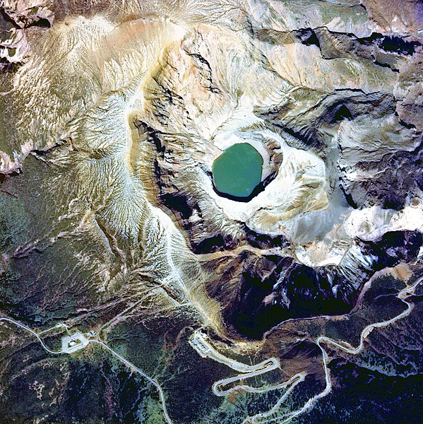
English: Aerial photo of Okama, the crater lake of Mt. Zaō volcano, Japan, in 1976
日本語: 1976年度(昭和51年度)に撮影された「御釜」周辺の国土画像情報(カラー空中写真)
|
| Data | |
| Jatorria |
「国土画像情報(カラー空中写真) 国土交通省」 http://w3land.mlit.go.jp/cgi-bin/WebGIS2/WC_AirPhoto.cgi?IT=p&DT=n&PFN=CTO-76-20&PCN=C17&IDX=14 |
| Egilea | retouched by neuropower |
| Kameraren kokapena | | Irudi hau eta gehiago beraien kokapenekin hurrengo lekuetan: OpenStreetMap |
|---|
Lizentzia

|
The copyright holder of this file, the Ministry of Land, Infrastructure, Transport and Tourism of Japan, allows anyone to use it for any purpose, provided that the copyright holder is properly attributed. Redistribution, derivative work, commercial use, and all other use is permitted. |
Aitortu:
Copyright © National Land Image Information (Color Aerial Photographs), Ministry of Land, Infrastructure, Transport and Tourism
|
 |
This image is copyrighted by the Ministry of Land, Infrastructure, Transport and Tourism of Japan. For terms of use, see the stipulation to use of National Land Information (in Japanese) and message from MLIT (in Japanese and English). When you display this image on an article, include the following phrase in the description: "Made based on National Land Image Information (Color Aerial Photographs), Ministry of Land, Infrastructure, Transport and Tourism".
|
| Annotations | This image is annotated: View the annotations at Commons |
Fitxategiaren historia
Data/orduan klik egin fitxategiak orduan zuen itxura ikusteko.
| Data/Ordua | Iruditxoa | Neurriak | Erabiltzailea | Iruzkina | |
|---|---|---|---|---|---|
| oraingoa | 09:59, 18 urria 2017 | | 3.423 × 3.428 (15,62 MB) | Togabi | Color adjustment. |
| 05:54, 4 ekaina 2010 |  | 3.423 × 3.428 (3,37 MB) | Neuropower | {{Information |Description={{en|1=Aerial photo of Okama, the crater lake of Mt. Zaō in fiscal 1976}} {{ja|1=1976年度(昭和51年度)に撮影された「御釜」周辺の国土画像情報(カラー空中写真)}} |Source=「国土画像情報 |
Irudira dakarten loturak
Hurrengo orrialdeek dute fitxategi honetarako lotura:
Fitxategiaren erabilera orokorra
Hurrengo beste wikiek fitxategi hau darabilte:
- de.wikipedia.org proiektuan duen erabilera
- en.wikipedia.org proiektuan duen erabilera
- et.wikipedia.org proiektuan duen erabilera
- ja.wikipedia.org proiektuan duen erabilera
- ne.wikipedia.org proiektuan duen erabilera
- sr.wikipedia.org proiektuan duen erabilera
- uz.wikipedia.org proiektuan duen erabilera
- www.wikidata.org proiektuan duen erabilera