
Fitxategi:Arctic.svg

SVG fitxategi honen PNG aurreikuspenaren tamaina: 478 × 599 pixel. Bestelako bereizmenak: 191 × 240 pixel | 383 × 480 pixel | 613 × 768 pixel | 817 × 1.024 pixel | 1.634 × 2.048 pixel | 505 × 633 pixel.
Bereizmen handikoa (SVG fitxategia, nominaldi 505 × 633 pixel, fitxategiaren tamaina: 1,5 MB)
Fitxategi hau Wikimedia Commonsekoa da. Hango deskribapen orriko informazioa behean duzu. |
Laburpena
| Deskribapena |
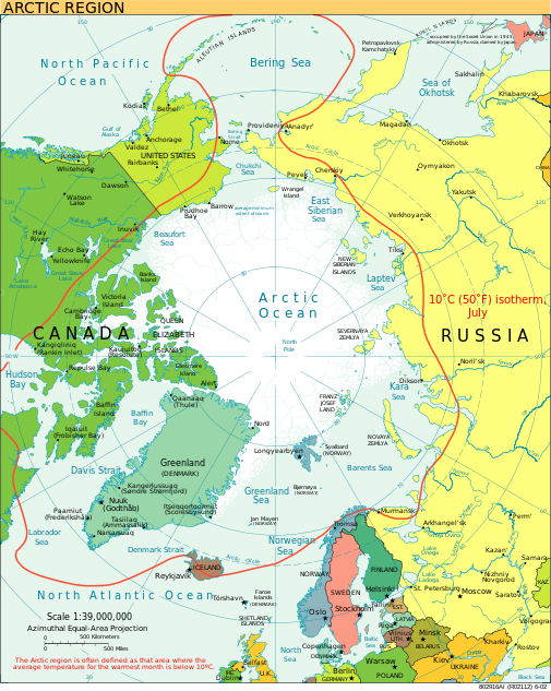
English: A view of the Arctic. The 10 °C (50 °F) mean isotherm in July line, displayed red, is commonly used to define the border of the Arctic region. |
| Data | 2013ko otsaila (Jatorrizko igoera-data) |
| Jatorria | CIA World Factbook |
| Egilea | CIA World Factbook |
| Beste bertsioak |
[]
|


.svg)


|
SVG fitxategi honek Inkscape edo Adobe Illustrator bezalako SVG editore bat erabiliz erraz itzul daitekeen barneratutako testua du. Argibide gehiago. Nahi izanez gero, fitxategia jaitsi eta testu editore bat erabiliz ere itzul dezakezu. |
Lizentzia
This image is in the public domain because it contains materials that originally came from the United States Central Intelligence Agency's World Factbook.
|
 |
Fitxategiaren historia
Data/orduan klik egin fitxategiak orduan zuen itxura ikusteko.
| Data/Ordua | Iruditxoa | Neurriak | Erabiltzailea | Iruzkina | |
|---|---|---|---|---|---|
| oraingoa | 23:00, 11 abuztua 2023 | | 505 × 633 (1,5 MB) | Mahagaja | correct spelling of Kangiqliniq |
| 20:29, 9 abuztua 2009 |  | 505 × 633 (1,5 MB) | Ysangkok | compact code, no visible changes afaik | |
| 01:34, 20 abuztua 2007 |  | 505 × 633 (1,63 MB) | StephenHudson | Reverted to earlier revision | |
| 00:18, 20 abuztua 2007 |  | 1.010 × 1.267 (1,4 MB) | StephenHudson | Increased base pixel size to make text readable. | |
| 19:17, 24 urtarrila 2006 |  | 505 × 633 (1,63 MB) | Moyogo | stripped useless stuff | |
| 22:32, 23 urtarrila 2006 |  | 505 × 633 (1,95 MB) | Sanao | Arctic<br /> Origin : CIA World Factbook Category:SVG maps Category:Arctic |
Irudira dakarten loturak
Hurrengo orrialdeek dute fitxategi honetarako lotura:
Fitxategiaren erabilera orokorra
Hurrengo beste wikiek fitxategi hau darabilte:
- ace.wikipedia.org proiektuan duen erabilera
- ady.wikipedia.org proiektuan duen erabilera
- af.wikipedia.org proiektuan duen erabilera
- ar.wikipedia.org proiektuan duen erabilera
- arz.wikipedia.org proiektuan duen erabilera
- ast.wikipedia.org proiektuan duen erabilera
- as.wikipedia.org proiektuan duen erabilera
- ba.wikipedia.org proiektuan duen erabilera
- be.wikipedia.org proiektuan duen erabilera
- bg.wikipedia.org proiektuan duen erabilera
- bn.wikipedia.org proiektuan duen erabilera
- ca.wikipedia.org proiektuan duen erabilera
- cy.wikipedia.org proiektuan duen erabilera
- da.wikipedia.org proiektuan duen erabilera
- da.wiktionary.org proiektuan duen erabilera
- de.wikipedia.org proiektuan duen erabilera
- dty.wikipedia.org proiektuan duen erabilera
- el.wikipedia.org proiektuan duen erabilera
- en.wikipedia.org proiektuan duen erabilera
- Geography of Denmark
- Jan Mayen
- Svalbard
- Northern Canada
- History of Svalbard
- Contour line
- List of rivers of the Americas by coastline
- Arctic Bridge
- History of the petroleum industry in Canada (frontier exploration and development)
- Portal:Maps/Maps/Nautical
- Portal:Maps/Maps/Nautical/2
- Arctic Ocean
- Wikipedia:Graphics Lab/Map workshop/Archive/Aug 2009
- Sir James Lamont, 1st Baronet
- Arctic exploration
- Portal:Oceans
- en.wikibooks.org proiektuan duen erabilera
- eo.wikipedia.org proiektuan duen erabilera
Ikus fitxategi honen erabilpen global gehiago.