
Fitxategi:Barents sp.png
Barents_sp.png ((655 × 599 pixel, fitxategiaren tamaina: 170 KB, MIME mota: image/png))
Fitxategi hau Wikimedia Commonsekoa da. Hango deskribapen orriko informazioa behean duzu. |
Laburpena
| Deskribapena |
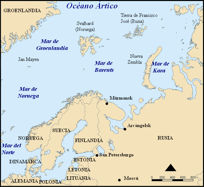
Español: Situación del Mar de Barents.
Mapa del mar de Barents en español. Barents sea map in Spanish. |
| Data | |
| Jatorria | Modified from Image:Barents sea map blank.png |
| Egilea | Alfanje |
| Beste bertsioak |
[]
|


This picture was modified from Barents_sea_map.png, bellow you'll find the tag and the information on the previous image
This map shows the location of the Barents Sea north of Russia and Norway, and the surrounding seas and islands.
Created by NormanEinstein, November 25, 2005.
Modified and blanked by historicair 22:27, 28 February 2006 (UTC)

|
Baimena duzu dokumentu hau kopiatu, banatu edo/eta aldatzeko GNU Free Documentation License baldintzapean, Free Software Foundationek argitaratutako 1.2 edo ondorengo bertsioan; sekzio aldaezinik gabe, azaleko testurik gabe, eta atzeko azaleko testurik gabe. Lizentziaren kopia dago GNU Free Documentation License izenburudun atalean. |
| Fitxategi hau Creative Commons Attribution-Share Alike 3.0 Unported lizentziapean dago. | ||
| ||
| This licensing tag was added to this file as part of the GFDL licensing update. |
Fitxategiaren historia
Data/orduan klik egin fitxategiak orduan zuen itxura ikusteko.
| Data/Ordua | Iruditxoa | Neurriak | Erabiltzailea | Iruzkina | |
|---|---|---|---|---|---|
| oraingoa | 17:32, 17 maiatza 2006 | | 655 × 599 (170 KB) | Alfanje~commonswiki | Mapa del mar de Barents en español. Barents sea map in Spanish. Modified from Image:Barents sea blank map.png |
Irudira dakarten loturak
Hurrengo orrialdeek dute fitxategi honetarako lotura:
Fitxategiaren erabilera orokorra
Hurrengo beste wikiek fitxategi hau darabilte:
- ca.wikipedia.org proiektuan duen erabilera
- es.wikipedia.org proiektuan duen erabilera
- gl.wikipedia.org proiektuan duen erabilera
- pl.wiktionary.org proiektuan duen erabilera