
Fitxategi:BritishEmpire1920.png

Aurreikuspen honen neurria: 800 × 351 pixel. Bestelako bereizmenak: 320 × 140 pixel | 640 × 281 pixel | 1.425 × 625 pixel.
Bereizmen handikoa ((1.425 × 625 pixel, fitxategiaren tamaina: 49 KB, MIME mota: image/png))
Fitxategi hau Wikimedia Commonsekoa da. Hango deskribapen orriko informazioa behean duzu. |
Laburpena
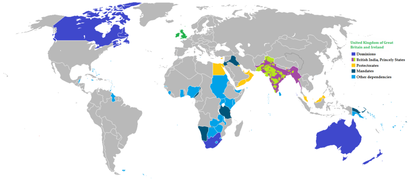
| Deskribapena |
English: A map of all the official territorial claims of the British Empire that it held in 1920 which identifies what type of holding was present on all possessions during that year.
Deutsch: Eine Karte von allen offiziellen territoriale Ansprüche des britischen Weltreiches, dass es im Jahr 1920 statt, die, welche Art von Betrieb auf allen Besitz war in diesem Jahr.
فارسی: نقشه بیمورد از همه ادعاهای ارضی رسمی امپراطوری بریتانیا که در سال 1920 که برای شناسایی نوع برگزاری در حال حاضر تمام اموال در آن سال برگزار شد.
Français : Une carte de toutes les revendications territoriales officiels de l'Empire britannique qu'elle détenait en 1920, qui identifie ce type d'exploitation a été présent sur toutes les possessions durant cette année.
Español: Un mapa de todas las afirmaciones oficiales territorial del Imperio británico que se celebrará en 1920, que identifica el tipo de la celebración estuvo presente en todas las posesiones durante ese año.
日本語: それは持ち株の種類はその年の間にすべての財産上に存在していたものを識別する1920年に開催された大英帝国のすべての正式な領土権の主張の地図。
हिन्दी: नक्शा ब्रिटिश साम्राज्य के सभी सरकारी प्रादेशिक का दावा है कि यह +१,९२० में आयोजित की जो पहचानती है कि वर्ष के दौरान किस प्रकार के आयोजन की सारी संपत्ति पर मौजूद थे.
Nederlands: Een kaart van alle officiële territoriale aanspraken van het Britse Rijk, dat het gehouden in 1920 waarin wordt aangegeven welk type van het bedrijf was aanwezig op alle bezittingen in dat jaar.
Português: Mapa de todos os territórios reclamados pelo Império Britânico, em 1920, que identifica o tipo de presença britânica no local naquele ano.
Tiếng Việt: Một bản đồ hiển thị tất cả các lãnh thổ của Đế quốc Anh năm 1920 trong đó xác định loại hình đang nắm giữ đã có mặt trên tất cả các vật sở hữu trong năm đó. |
| Data | |
| Jatorria |
The following: |
| Egilea | Zd |
Lizentzia

|
Baimena duzu dokumentu hau kopiatu, banatu edo/eta aldatzeko GNU Free Documentation License baldintzapean, Free Software Foundationek argitaratutako 1.2 edo ondorengo bertsioan; sekzio aldaezinik gabe, azaleko testurik gabe, eta atzeko azaleko testurik gabe. Lizentziaren kopia dago GNU Free Documentation License izenburudun atalean. |
| Fitxategi hau Creative Commons Attribution-Share Alike 3.0 Unported lizentziapean dago. | ||
| ||
| This licensing tag was added to this file as part of the GFDL licensing update. |
Fitxategiaren historia
Data/orduan klik egin fitxategiak orduan zuen itxura ikusteko.
| Data/Ordua | Iruditxoa | Neurriak | Erabiltzailea | Iruzkina | |
|---|---|---|---|---|---|
| oraingoa | 10:42, 31 urria 2021 | | 1.425 × 625 (49 KB) | Randomastwritter | jubaland |
| 12:50, 14 abuztua 2011 |  | 1.425 × 625 (64 KB) | The Monarch | New Version | |
| 12:44, 15 uztaila 2011 |  | 1.425 × 625 (67 KB) | Zd | {{Information |description={{en|1=A map of all the official territorial claims of the British Empire that it held in 1920 which identifies what type of holding was present on all possessions during that year.}} {{de|1=Eine Karte von | |
| 11:55, 15 uztaila 2011 |  | 1.425 × 625 (67 KB) | Zd |
Irudira dakarten loturak
Hurrengo orrialdeek dute fitxategi honetarako lotura:
Fitxategiaren erabilera orokorra
Hurrengo beste wikiek fitxategi hau darabilte:
- da.wikipedia.org proiektuan duen erabilera
- es.wikipedia.org proiektuan duen erabilera
- ml.wikipedia.org proiektuan duen erabilera
- ms.wikipedia.org proiektuan duen erabilera
- ne.wikipedia.org proiektuan duen erabilera
- sah.wikipedia.org proiektuan duen erabilera
- vi.wikipedia.org proiektuan duen erabilera
- xh.wikipedia.org proiektuan duen erabilera