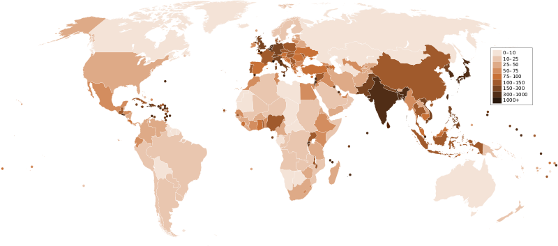
Fitxategi:Countries by population density.svg

SVG fitxategi honen PNG aurreikuspenaren tamaina: 800 × 353 pixel. Bestelako bereizmenak: 320 × 141 pixel | 640 × 282 pixel | 1.024 × 452 pixel | 1.280 × 565 pixel | 2.560 × 1.129 pixel | 6.000 × 2.647 pixel.
Bereizmen handikoa (SVG fitxategia, nominaldi 6.000 × 2.647 pixel, fitxategiaren tamaina: 1,62 MB)
Fitxategiaren historia
Data/orduan klik egin fitxategiak orduan zuen itxura ikusteko.
| Data/Ordua | Iruditxoa | Neurriak | Erabiltzailea | Iruzkina | |
|---|---|---|---|---|---|
| oraingoa | 01:33, 22 abendua 2011 |  | 6.000 × 2.647 (1,62 MB) | Quibik | added transparency |
| 15:43, 20 otsaila 2011 |  | 6.000 × 2.647 (1,62 MB) | Erik del Toro Streb | typographically corrected | |
| 04:22, 7 urtarrila 2008 |  | 6.000 × 2.647 (1,62 MB) | Briefplan~commonswiki | {{Information |Description=A map of the world, with colours to highlight the population density of each country or territory. Numbers on the legend are in people per km<sup>2</sup>, and all countries smaller than 20,000 km<sup>2</sup> are represented by a |
Irudira dakarten loturak
Hurrengo orrialdeek dute fitxategi honetarako lotura:
Fitxategiaren erabilera orokorra
Hurrengo beste wikiek fitxategi hau darabilte:
- af.wikipedia.org proiektuan duen erabilera
- ar.wikipedia.org proiektuan duen erabilera
- arz.wikipedia.org proiektuan duen erabilera
- ast.wikipedia.org proiektuan duen erabilera
- av.wikipedia.org proiektuan duen erabilera
- awa.wikipedia.org proiektuan duen erabilera
- azb.wikipedia.org proiektuan duen erabilera
- az.wikipedia.org proiektuan duen erabilera
- ba.wikipedia.org proiektuan duen erabilera
- be.wikipedia.org proiektuan duen erabilera
- bg.wikipedia.org proiektuan duen erabilera
- bs.wikipedia.org proiektuan duen erabilera
- ca.wikipedia.org proiektuan duen erabilera
- ckb.wikipedia.org proiektuan duen erabilera
- cs.wikipedia.org proiektuan duen erabilera
- cy.wikipedia.org proiektuan duen erabilera
- de.wikipedia.org proiektuan duen erabilera
- de.wikiversity.org proiektuan duen erabilera
- diq.wikipedia.org proiektuan duen erabilera
- dsb.wikipedia.org proiektuan duen erabilera
- en.wikipedia.org proiektuan duen erabilera
- eo.wikipedia.org proiektuan duen erabilera
- es.wikipedia.org proiektuan duen erabilera
- fi.wikipedia.org proiektuan duen erabilera
- fr.wikipedia.org proiektuan duen erabilera
- gl.wikipedia.org proiektuan duen erabilera
Ikus fitxategi honen erabilpen global gehiago.

