
Fitxategi:Glandy Cross and the Cross Inn - geograph.org.uk - 1707476.jpg
Glandy_Cross_and_the_Cross_Inn_-_geograph.org.uk_-_1707476.jpg ((800 × 600 pixel, fitxategiaren tamaina: 137 KB, MIME mota: image/jpeg))
Fitxategi hau Wikimedia Commonsekoa da. Hango deskribapen orriko informazioa behean duzu. |
Laburpena
| Deskribapena |
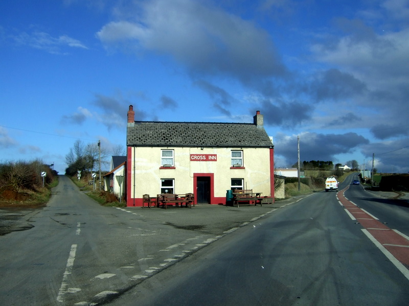
English: Glandy Cross and the Cross Inn The pub faces the road intersection that the village is named for: on the right is the A478 old turnpike route heading towards Cardigan, left the minor road to Mynachclogddu. Roads also run west and east at this point.
Although this is on the surface this looks a somewhat dull, flat landscape it has important prehistoric and historic roots: there is a multiplicity of Neolithic and Bronze Age remains in the area still visible, and in the Middle Ages the land (much of it owned by the Cistercians at Whitland Abbey) was held under Welsh systems of tenure and farmed communally. "Sixteenth-century leases make it clear that tenants were practising common pasturage and the survival of arian y mynydd or 'mountain silver', a payment for grazing rights, with a diversity of rents, in both cash, kind and service, suggests that they correspond with earlier villein obligations, when most of the tenants were also bound to do boon work for the monastery." Some of the moorland here remained unenclosed until the C19. See Archaeology in Wales http://www.cambria.org.uk/HLC/Preseli/area/area265.htm |
| Data | |
| Jatorria | From geograph.org.uk |
| Egilea | ceridwen |
| Aitortu (required by the license) | ceridwen / Glandy Cross and the Cross Inn / |
| Kameraren kokapena | | Irudi hau eta gehiago beraien kokapenekin hurrengo lekuetan: OpenStreetMap |
|---|
_heading:45.00&language=eu)
| Objektuaren kokapena | | Irudi hau eta gehiago beraien kokapenekin hurrengo lekuetan: OpenStreetMap |
|---|
_heading:45.00&language=eu)
Lizentzia

|
This image was taken from the Geograph project collection. See this photograph's page on the Geograph website for the photographer's contact details. The copyright on this image is owned by ceridwen and is licensed for reuse under the Creative Commons Attribution-ShareAlike 2.0 license.
|
- Askea zara:
- partekatzeko – lana kopiatzeko, banatzeko eta bidaltzeko
- birnahasteko – lana moldatzeko
- Ondorengo baldintzen pean:
- eskuduntza – Egiletza behar bezala aitortu behar duzu, lizentzia ikusteko esteka gehitu, eta ea aldaketak egin diren aipatu. Era egokian egin behar duzu hori guztia, baina inola ere ez egileak zure lana edo zure erabilera babesten duela irudikatuz.
- berdin partekatu – Lan honetan oinarrituta edo aldatuta berria eraikitzen baduzu, emaitza lana hau bezalako lizentzia batekin argitaratu behar duzu.
Fitxategiaren historia
Data/orduan klik egin fitxategiak orduan zuen itxura ikusteko.
| Data/Ordua | Iruditxoa | Neurriak | Erabiltzailea | Iruzkina | |
|---|---|---|---|---|---|
| oraingoa | 07:06, 5 martxoa 2011 | | 800 × 600 (137 KB) | GeographBot | == {{int:filedesc}} == {{Information |description={{en|1=Glandy Cross and the Cross Inn The pub faces the road intersection that the village is named for: on the right is the A478 old turnpike route heading towards Cardigan, left the minor road to Mynachc |
Irudira dakarten loturak
Hurrengo orrialdeek dute fitxategi honetarako lotura:
Fitxategiaren erabilera orokorra
Hurrengo beste wikiek fitxategi hau darabilte:
- en.wikipedia.org proiektuan duen erabilera