
Fitxategi:Iraq.A2003060.0750.500m.jpg

Bereizmen handikoa ((2.000 × 2.600 pixel, fitxategiaren tamaina: 1.012 KB, MIME mota: image/jpeg))
Fitxategi hau Wikimedia Commonsekoa da. Hango deskribapen orriko informazioa behean duzu. |
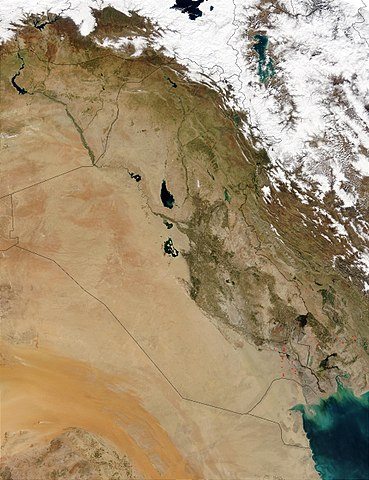
This Moderate Resolution Imaging Spectroradiometer (MODIS) image from March 1, 2003, shows numerous oil well flares (the burning off of combustible gases associated with oil) in southern Iraq (center). The way the active hot spots, marked in red, line up almost vertically suggests they are along a pipeline. Meanwhile, hot spots in southern Iran (right) are likely agricultural fires.
http://visibleearth.nasa.gov/view_rec.php?id=5166
| This file is in the public domain in the United States because it was solely created by NASA. NASA copyright policy states that "NASA material is not protected by copyright unless noted". (See Template:PD-USGov, NASA copyright policy page or JPL Image Use Policy.) | ||
 |
Warnings:
|
Fitxategiaren historia
Data/orduan klik egin fitxategiak orduan zuen itxura ikusteko.
| Data/Ordua | Iruditxoa | Neurriak | Erabiltzailea | Iruzkina | |
|---|---|---|---|---|---|
| oraingoa | 17:05, 26 urria 2005 | | 2.000 × 2.600 (1.012 KB) | Brian0918 | This Moderate Resolution Imaging Spectroradiometer (MODIS) image from March 1, 2003, shows numerous oil well flares (the burning off of combustible gases associated with oil) in southern Iraq (center). The way the active hot spots, marked in red, line up |
Irudira dakarten loturak
Ez dago fitxategi hau darabilen orririk.
Fitxategiaren erabilera orokorra
Hurrengo beste wikiek fitxategi hau darabilte:
- ar.wikipedia.org proiektuan duen erabilera
- ar.wikiquote.org proiektuan duen erabilera
- da.wikipedia.org proiektuan duen erabilera
- en.wikipedia.org proiektuan duen erabilera
- fi.wikipedia.org proiektuan duen erabilera
- gl.wikipedia.org proiektuan duen erabilera
- hr.wikipedia.org proiektuan duen erabilera
- hy.wikipedia.org proiektuan duen erabilera
- ka.wikipedia.org proiektuan duen erabilera
- km.wikipedia.org proiektuan duen erabilera
- ko.wikipedia.org proiektuan duen erabilera
- lt.wikipedia.org proiektuan duen erabilera
- mn.wikipedia.org proiektuan duen erabilera
- nn.wikipedia.org proiektuan duen erabilera
- no.wikipedia.org proiektuan duen erabilera
- nrm.wikipedia.org proiektuan duen erabilera
- pl.wikipedia.org proiektuan duen erabilera
- pt.wikipedia.org proiektuan duen erabilera
- sh.wikipedia.org proiektuan duen erabilera
- sl.wikipedia.org proiektuan duen erabilera
- sr.wikipedia.org proiektuan duen erabilera
- sv.wikipedia.org proiektuan duen erabilera
- te.wikipedia.org proiektuan duen erabilera
- tr.wikipedia.org proiektuan duen erabilera
- uk.wikipedia.org proiektuan duen erabilera
- zh.wikipedia.org proiektuan duen erabilera