
Fitxategi:Konya districts.png

Aurreikuspen honen neurria: 737 × 599 pixel. Bestelako bereizmenak: 295 × 240 pixel | 590 × 480 pixel | 958 × 779 pixel.
Bereizmen handikoa ((958 × 779 pixel, fitxategiaren tamaina: 56 KB, MIME mota: image/png))
Fitxategi hau Wikimedia Commonsekoa da. Hango deskribapen orriko informazioa behean duzu. |
Laburpena
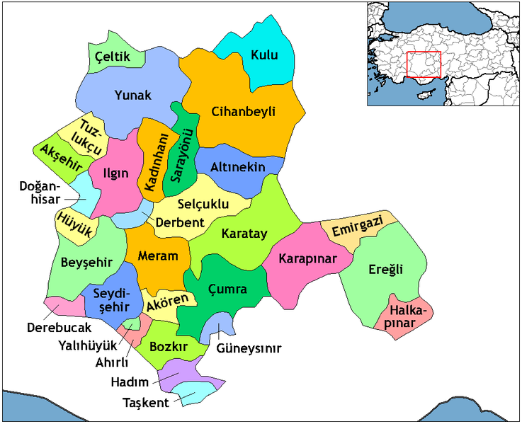
Created by Rarelibra 22:01, 1 December 2006 (UTC) for public domain use, using MapInfo Professional v8.5 and various mapping resources. Edited by One Homo Sapiens Corrected text where İ,Ş,ı,ğ,or ş occurs in name. Source: [statoids-com]. Increased font size and enhanced color differences among adjacent districts.
| Deskribapena |
English: Map of the districts in the Province of Konya — in the Central Anatolia Region of Asian Turkey.
Svenska: Konya_Districts.png |
| Data | |
| Jatorria | Created by Rarelibra, edited by One Homo Sapiens |
| Egilea | Rarelibra, One Homo Sapiens |
Lizentzia
| Nik, lan honen egile eskubideen jabeak, lan hau domeinu publikoan jartzen dut. Mundu osoan du eragina honek. Estatu batzuetan beharbada hori ez da legez posible izango. Halakoetan: Edonori ematen diot lan hau edozertarako erabiltzeko eskubidea, inolako baldintzarik gabe, legeak nahitaez ezarritako baldintzak izan ezik. |
Fitxategiaren historia
Data/orduan klik egin fitxategiak orduan zuen itxura ikusteko.
| Data/Ordua | Iruditxoa | Neurriak | Erabiltzailea | Iruzkina | |
|---|---|---|---|---|---|
| oraingoa | 23:06, 29 urria 2014 | | 958 × 779 (56 KB) | Kimsaka | white frame cropped |
| 12:14, 23 ekaina 2011 |  | 1.056 × 816 (55 KB) | Yrytyr | Districts of Konya | |
| 21:00, 8 otsaila 2011 |  | 730 × 600 (222 KB) | Kurdische 1 | Districts Of Konya | |
| 20:50, 8 otsaila 2011 |  | 730 × 600 (220 KB) | Kurdische 1 | Districtrs Of Konya | |
| 20:08, 8 otsaila 2011 |  | 800 × 600 (270 KB) | Kurdische 1 | Districts Of Konya | |
| 16:43, 5 otsaila 2011 |  | 712 × 583 (221 KB) | Kurdische 1 | Districts_of_Konya.png | |
| 16:31, 5 otsaila 2011 |  | 960 × 720 (232 KB) | Kurdische 1 | Districts_of_Konya.png | |
| 20:03, 20 urtarrila 2011 |  | 800 × 600 (162 KB) | Kurdische 1 | Konya_Turkey_Districts.png | |
| 19:46, 20 urtarrila 2011 |  | 1.056 × 816 (46 KB) | Kurdische 1 | Reverted to version as of 22:01, 1 December 2006 | |
| 03:26, 29 abendua 2008 |  | 1.056 × 816 (55 KB) | One Homo Sapiens | Corrected text where İ,Ş,ı,ğ,or ş occurs in name. Source: [statoids-com]. Increased font size and enhanced color differences among adjacent districts. |
Irudira dakarten loturak
Hurrengo orrialdeek dute fitxategi honetarako lotura:
Fitxategiaren erabilera orokorra
Hurrengo beste wikiek fitxategi hau darabilte:
- ar.wikipedia.org proiektuan duen erabilera
- ast.wikipedia.org proiektuan duen erabilera
- av.wikipedia.org proiektuan duen erabilera
- azb.wikipedia.org proiektuan duen erabilera
- ba.wikipedia.org proiektuan duen erabilera
- be.wikipedia.org proiektuan duen erabilera
- ca.wikipedia.org proiektuan duen erabilera
- ceb.wikipedia.org proiektuan duen erabilera
- ce.wikipedia.org proiektuan duen erabilera
- da.wikipedia.org proiektuan duen erabilera
- de.wikipedia.org proiektuan duen erabilera
- Konya
- Ereğli (Konya)
- Konya (Provinz)
- Diskussion:Konya
- Akşehir
- Beyşehir
- Doğanhisar
- Kulu (Konya)
- Cihanbeyli
- Vorlage:Navigationsleiste Landkreise der Provinz Konya
- Ahırlı
- Akören
- Altınekin
- Bozkır
- Çeltik
- Çumra
- Derbent (Konya)
- Derebucak
- Emirgazi
- Güneysınır
- Hadim (Konya)
- Halkapınar
- Hüyük
- Ilgın
- Kadınhanı
- Karatay (Konya)
- Meram (Konya)
- Sarayönü
- Selçuklu
- Seydişehir
- Taşkent
- Tuzlukçu
Ikus fitxategi honen erabilpen global gehiago.