
Fitxategi:LanguageMap-Kikongo-Kituba.png

Bereizmen handikoa ((1.420 × 939 pixel, fitxategiaren tamaina: 89 KB, MIME mota: image/png))
Fitxategi hau Wikimedia Commonsekoa da. Hango deskribapen orriko informazioa behean duzu. |
Laburpena
| Deskribapena |
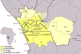
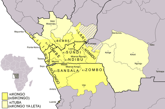
Dialect map of Kikongo. Dark yellow areas are inhabited mainly by first language speakers of the various dialects/languages of Kikongo. Names of some dialects/languages are written on the map. Pale yellow areas are inhabited by first and second language speakers of Kituba (a.k.a. Kikongo ya Leta), which is the lingua franca in the area. Kituba is understood by most speakers of Kikongo. Map drawn by Risto Kupsala. Details are based on the language maps of Ethnologue and several other sources. |
| Data | 2006ko apirilaren 2a (Jatorrizko igoera-data) |
| Jatorria | No machine-readable source provided. Own work assumed (based on copyright claims). |
| Egilea | No machine-readable author provided. Rasulo~commonswiki assumed (based on copyright claims). |
Lizentzia
| Nik, lan honen egile eskubideen jabeak, lan hau domeinu publikoan jartzen dut. Mundu osoan du eragina honek. Estatu batzuetan beharbada hori ez da legez posible izango. Halakoetan: Edonori ematen diot lan hau edozertarako erabiltzeko eskubidea, inolako baldintzarik gabe, legeak nahitaez ezarritako baldintzak izan ezik. |
Fitxategiaren historia
Data/orduan klik egin fitxategiak orduan zuen itxura ikusteko.
| Data/Ordua | Iruditxoa | Neurriak | Erabiltzailea | Iruzkina | |
|---|---|---|---|---|---|
| oraingoa | 02:37, 25 otsaila 2021 | | 1.420 × 939 (89 KB) | Somebody040404 | Reverted to version as of 10:10, 29 March 2018 (UTC) |
| 02:26, 25 otsaila 2021 |  | 1.420 × 939 (82 KB) | Somebody040404 | ||
| 12:10, 29 martxoa 2018 |  | 1.420 × 939 (89 KB) | Maphobbyist | South Sudan border | |
| 23:24, 20 abendua 2007 |  | 1.420 × 939 (60 KB) | Rasulo~commonswiki | Dialect map of Kikongo. Dark yellow areas are inhabited mainly by native speakers of the various dialects/languages of Ki(si)kongo. Names of some dialects/languages are written on the map. Pale yellow areas are inhabited by first and second language speak | |
| 14:12, 22 uztaila 2006 |  | 718 × 518 (26 KB) | Rasulo~commonswiki | ||
| 11:49, 2 apirila 2006 |  | 571 × 471 (20 KB) | Rasulo~commonswiki | Dialect map of Kikongo Dark green areas are inhabited mainly by first language speakers of the various dialects/languages of Kikongo. Names of some dialects/languages are written on the map. Light green areas are inhabited by first and second language spe |
Irudira dakarten loturak
Hurrengo orrialdeek dute fitxategi honetarako lotura:
Fitxategiaren erabilera orokorra
Hurrengo beste wikiek fitxategi hau darabilte:
- af.wikipedia.org proiektuan duen erabilera
- ar.wikipedia.org proiektuan duen erabilera
- ast.wikipedia.org proiektuan duen erabilera
- az.wiktionary.org proiektuan duen erabilera
- bn.wikipedia.org proiektuan duen erabilera
- ca.wikipedia.org proiektuan duen erabilera
- cs.wikipedia.org proiektuan duen erabilera
- da.wikipedia.org proiektuan duen erabilera
- de.wikipedia.org proiektuan duen erabilera
- en.wikipedia.org proiektuan duen erabilera
- eo.wikipedia.org proiektuan duen erabilera
- es.wikipedia.org proiektuan duen erabilera
- fi.wikipedia.org proiektuan duen erabilera
- frr.wikipedia.org proiektuan duen erabilera
- fr.wikipedia.org proiektuan duen erabilera
- fr.wiktionary.org proiektuan duen erabilera
Ikus fitxategi honen erabilpen global gehiago.