
Fitxategi:Pacaya erupting in 1976.jpg
Aurreikuspen honen neurria: 800 × 522 pixel. Bestelako bereizmenak: 320 × 209 pixel | 640 × 417 pixel | 969 × 632 pixel.
Bereizmen handikoa ((969 × 632 pixel, fitxategiaren tamaina: 60 KB, MIME mota: image/jpeg))
Fitxategi hau Wikimedia Commonsekoa da. Hango deskribapen orriko informazioa behean duzu. |
Laburpena
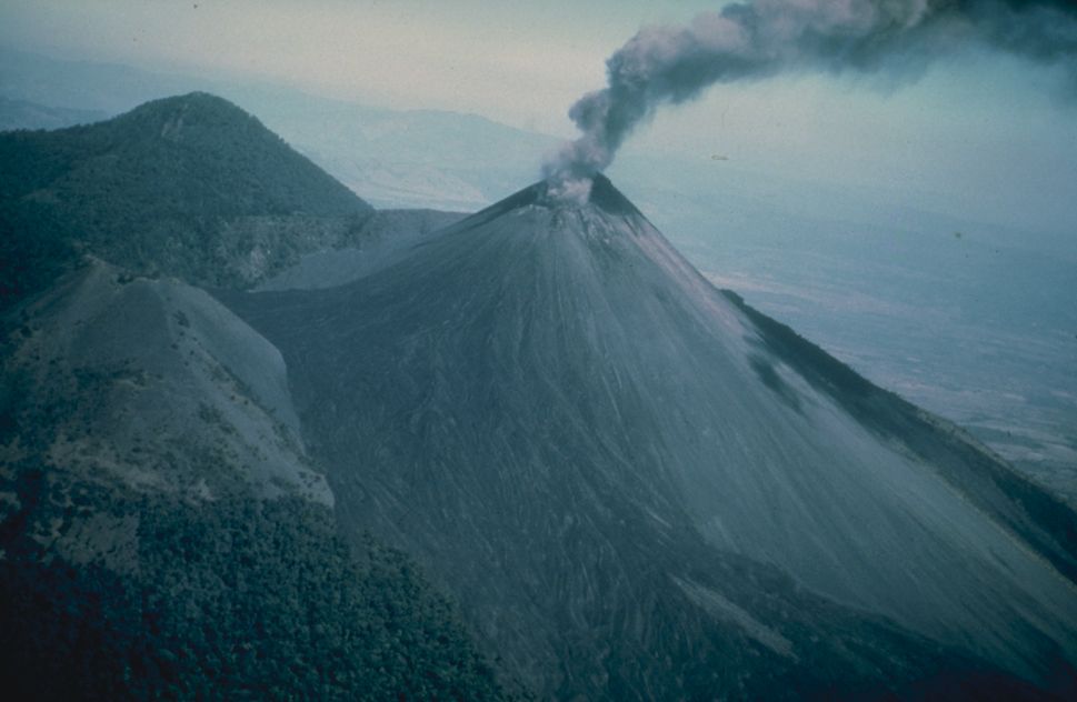
| Deskribapena | Ashy eruption at Pacaya, shortly after a very large earthquake affected the area in 1976. Photo credit: USGS. . |
| Data | |
| Jatorria | From [1] |
| Egilea | USGS |
Lizentzia
This image is in the public domain in the United States because it only contains materials that originally came from the United States Geological Survey, an agency of the United States Department of the Interior. For more information, see the official USGS copyright policy.
|
Jatorrizko igoera erregistroa
The original description page was here. All following user names refer to en.wikipedia.
- 2005-04-06 14:27 Worldtraveller 969×632×8 (61084 bytes) Ashy eruption at Pacaya, shortly after a very large earthquake affected the area in 1976. Photo credit: USGS. From [http://www.ngdc.noaa.gov/seg/hazard/slideset/28/28_576_slide.shtml]. {{PD-USGov-Interior-USGS}}
Fitxategiaren historia
Data/orduan klik egin fitxategiak orduan zuen itxura ikusteko.
| Data/Ordua | Iruditxoa | Neurriak | Erabiltzailea | Iruzkina | |
|---|---|---|---|---|---|
| oraingoa | 01:36, 20 maiatza 2007 | | 969 × 632 (60 KB) | Yonidebest | {{Information |Description=Ashy eruption at Pacaya, shortly after a very large earthquake affected the area in 1976. Photo credit: USGS. From [http://www.ngdc.noaa.gov/seg/hazard/slideset/28/28_576_slide.shtml]. |Source=Originally from [http://en.wikipe |
Irudira dakarten loturak
Ez dago fitxategi hau darabilen orririk.
Fitxategiaren erabilera orokorra
Hurrengo beste wikiek fitxategi hau darabilte:
- ar.wikipedia.org proiektuan duen erabilera
- arz.wikipedia.org proiektuan duen erabilera
- az.wikipedia.org proiektuan duen erabilera
- ca.wikipedia.org proiektuan duen erabilera
- ceb.wikipedia.org proiektuan duen erabilera
- cs.wikipedia.org proiektuan duen erabilera
- de.wikipedia.org proiektuan duen erabilera
- de.wikinews.org proiektuan duen erabilera
- el.wikipedia.org proiektuan duen erabilera
- en.wikipedia.org proiektuan duen erabilera
- en.wikinews.org proiektuan duen erabilera
- en.wikivoyage.org proiektuan duen erabilera
- es.wikipedia.org proiektuan duen erabilera
- es.wikivoyage.org proiektuan duen erabilera
- fa.wikipedia.org proiektuan duen erabilera
- fi.wikipedia.org proiektuan duen erabilera
- fr.wikipedia.org proiektuan duen erabilera
- he.wikipedia.org proiektuan duen erabilera
- he.wikivoyage.org proiektuan duen erabilera
- hu.wikipedia.org proiektuan duen erabilera
- hy.wikipedia.org proiektuan duen erabilera
- id.wikipedia.org proiektuan duen erabilera
- it.wikipedia.org proiektuan duen erabilera
- it.wikivoyage.org proiektuan duen erabilera
- km.wikipedia.org proiektuan duen erabilera
- ko.wikipedia.org proiektuan duen erabilera
- li.wikipedia.org proiektuan duen erabilera
- lld.wikipedia.org proiektuan duen erabilera
- lt.wikipedia.org proiektuan duen erabilera
- ms.wikipedia.org proiektuan duen erabilera
- nl.wikipedia.org proiektuan duen erabilera
- nn.wikipedia.org proiektuan duen erabilera
- no.wikipedia.org proiektuan duen erabilera
- pl.wikipedia.org proiektuan duen erabilera
Ikus fitxategi honen erabilpen global gehiago.