
Fitxategi:SE2015Mar20T.png

Aurreikuspen honen neurria: 599 × 600 pixel. Bestelako bereizmenak: 240 × 240 pixel | 479 × 480 pixel | 728 × 729 pixel.
Bereizmen handikoa ((728 × 729 pixel, fitxategiaren tamaina: 27 KB, MIME mota: image/png))
Fitxategi hau Wikimedia Commonsekoa da. Hango deskribapen orriko informazioa behean duzu. |
Laburpena
| Deskribapena |
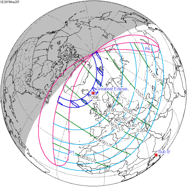
English: Solar eclipse A map of path on earth: Totality exists within the dark blue areas, partiality at the light blue areas. The eclipse occurs at sunrise or sunset in the pink areas. Light blue lines represent a constant fixed fraction of coverage. Green lines show lines of time for greatest coverage. For more information see [1] |
| Data | |
| Jatorria | http://eclipse.gsfc.nasa.gov/ |
| Egilea | Eclipse Predictions by Fred Espenak, NASA's GSFC |
![[1]](http://eclipse.gsfc.nasa.gov/SEplot/SEplot2001/SE2015Mar20T.GIF)
Lizentzia
| This file is in the public domain in the United States because it was solely created by NASA. NASA copyright policy states that "NASA material is not protected by copyright unless noted". (See Template:PD-USGov, NASA copyright policy page or JPL Image Use Policy.) | ||
 |
Warnings:
|
Jatorrizko igoera erregistroa
The original description page was here. All following user names refer to en.wikipedia.
- 2009-12-08 20:37 SockPuppetForTomruen 728×729× (91056 bytes)
- 2009-11-22 07:43 Tomruen 733×729× (91478 bytes) {{Information |Description = [[Solar eclipse]] map of path on earth |Source = http://eclipse.gsfc.nasa.gov/ |Date = 2000 |Author = Fred |Permission = Official work for NASA |other_versions = }} {{Attribution}} Attribution: '''Eclipse Pr
Fitxategiaren historia
Data/orduan klik egin fitxategiak orduan zuen itxura ikusteko.
| Data/Ordua | Iruditxoa | Neurriak | Erabiltzailea | Iruzkina | |
|---|---|---|---|---|---|
| oraingoa | 20:22, 16 uztaila 2015 | | 728 × 729 (27 KB) | Cmdrjameson | Compressed with pngout. Reduced by 62kB (70% decrease). |
| 10:40, 9 abuztua 2011 |  | 728 × 729 (89 KB) | OgreBot | (BOT): Reverting to most recent version; originally uploaded at en.wikipedia on 2009-12-08 20:37:41 by SockPuppetForTomruen | |
| 10:40, 9 abuztua 2011 |  | 733 × 729 (89 KB) | OgreBot | (BOT): Uploading old version of file from en.wikipedia; originally uploaded on 2009-11-22 07:43:35 by Tomruen | |
| 12:13, 13 martxoa 2011 |  | 728 × 729 (89 KB) | SamZane | {{Information |Description ={{en|1=Solar eclipse of march 20 2015 map.}} |Source =NASA |Author =NASA |Date = |Permission = |other_versions = }} Category:Solar eclipse map |
Irudira dakarten loturak
Hurrengo orrialdeek dute fitxategi honetarako lotura:
Fitxategiaren erabilera orokorra
Hurrengo beste wikiek fitxategi hau darabilte:
- ar.wikipedia.org proiektuan duen erabilera
- كسوف الشمس 20 مارس 2015
- كسوف الشمس 1 يونيو 2011
- كسوف الشمس 1 سبتمبر 2016
- كسوف الشمس 26 فبراير 2017
- كسوف الشمس 25 أكتوبر 2022
- كسوف الشمس 12 أغسطس 2026
- كسوف الشمس 30 مارس 2033
- كسوف الشمس 5 يناير 2038
- كسوف الشمس 25 أكتوبر 2041
- كسوف الشمس 12 أغسطس 2045
- كسوف الشمس 31 مايو 2049
- كسوف الشمس 11 أبريل 2051
- كسوف الشمس 20 مارس 2034
- كسوف الشمس 20 مارس 2053
- كسوف الشمس 12 أغسطس 2064
- كسوف الشمس 5 يناير 2057
- كسوف الشمس 24 أكتوبر 2060
- كسوف الشمس 31 مايو 2068
- كسوف الشمس 21 أبريل 2069
- كسوف الشمس 6 يناير 2019
- كسوف الشمس 2 مايو 2087
- كسوف الشمس 1 يونيو 2087
- كسوف الشمس 19 مارس 2072
- كسوف الشمس 7 فبراير 2073
- كسوف الشمس 3 أغسطس 2073
- كسوف الشمس 27 يناير 2074
- كسوف الشمس 6 يناير 2076
- كسوف الشمس 24 أكتوبر 2079
- كسوف الشمس 21 مارس 2080
- كسوف الشمس 13 سبتمبر 2080
- كسوف الشمس 10 مارس 2081
- كسوف الشمس 13 أغسطس 2083
- كسوف الشمس 7 يناير 2084
- كسوف الشمس 3 يوليو 2084
- كسوف الشمس 27 ديسمبر 2084
- كسوف الشمس 22 يونيو 2085
- كسوف الشمس 16 ديسمبر 2085
- az.wikipedia.org proiektuan duen erabilera
- be.wikipedia.org proiektuan duen erabilera
- bg.wikipedia.org proiektuan duen erabilera
- bn.wikipedia.org proiektuan duen erabilera
- el.wikipedia.org proiektuan duen erabilera
- en.wikipedia.org proiektuan duen erabilera
Ikus fitxategi honen erabilpen global gehiago.