
Fitxategi:Scorpiones distribution.png

Aurreikuspen honen neurria: 800 × 388 pixel. Bestelako bereizmenak: 320 × 155 pixel | 640 × 310 pixel | 1.295 × 628 pixel.
Bereizmen handikoa ((1.295 × 628 pixel, fitxategiaren tamaina: 54 KB, MIME mota: image/png))
Fitxategi hau Wikimedia Commonsekoa da. Hango deskribapen orriko informazioa behean duzu. |
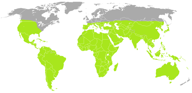
| Deskribapena | A blank map of the world as of 2008, with country outlines, for making country locator maps. This map uses the Robinson projection centered on the Greenwich Prime Meridian and includes various microstates and island nations. All territories indicated in the UN listing of territories and regions are exhibited. |
| Data | (UTC) |
| Jatorria | |
| Egilea |
|
| This is a retouched picture, which means that it has been digitally altered from its original version. Modifications: coloured. The original can be viewed here: BlankMap-World-Current.png: File:BlankMap-World-Current.png. Modifications made by B kimmel.
|
| Nik, lan honen egile eskubideen jabeak, lan hau domeinu publikoan jartzen dut. Mundu osoan du eragina honek. Estatu batzuetan beharbada hori ez da legez posible izango. Halakoetan: Edonori ematen diot lan hau edozertarako erabiltzeko eskubidea, inolako baldintzarik gabe, legeak nahitaez ezarritako baldintzak izan ezik. |
Jatorrizko igoera erregistroa
This image is a derivative work of the following images:
- File:BlankMap-World.png licensed with PD-user
- 2010-06-11T08:50:57Z Doopy 1480x628 (58752 Bytes) {{Information |Description=A blank map of the world as of 2008, with country outlines, for making country locator maps. This map uses the [[:en:Robinson projection|Robinson projection]] centered on the Greenwich Prime Meridi
Fitxategiaren historia
Data/orduan klik egin fitxategiak orduan zuen itxura ikusteko.
| Data/Ordua | Iruditxoa | Neurriak | Erabiltzailea | Iruzkina | |
|---|---|---|---|---|---|
| oraingoa | 18:47, 3 uztaila 2010 | | 1.295 × 628 (54 KB) | B kimmel | orange = green |
| 12:20, 29 ekaina 2010 |  | 1.295 × 628 (54 KB) | B kimmel | {{Information |Description=A blank map of the world as of 2008, with country outlines, for making country locator maps. This map uses the Robinson projection centered on the Greenwich Prime Meridian and includes various [[:en: |
Irudira dakarten loturak
Hurrengo orrialdeek dute fitxategi honetarako lotura:
Fitxategiaren erabilera orokorra
Hurrengo beste wikiek fitxategi hau darabilte:
- ast.wikipedia.org proiektuan duen erabilera
- azb.wikipedia.org proiektuan duen erabilera
- br.wikipedia.org proiektuan duen erabilera
- en.wikipedia.org proiektuan duen erabilera
- eo.wikipedia.org proiektuan duen erabilera
- es.wikipedia.org proiektuan duen erabilera
- fi.wikipedia.org proiektuan duen erabilera
- fr.wikipedia.org proiektuan duen erabilera
- he.wikipedia.org proiektuan duen erabilera
- id.wikipedia.org proiektuan duen erabilera
- kw.wikipedia.org proiektuan duen erabilera
- mrj.wikipedia.org proiektuan duen erabilera
- my.wikipedia.org proiektuan duen erabilera
- nl.wikipedia.org proiektuan duen erabilera
- os.wikipedia.org proiektuan duen erabilera
- ro.wikipedia.org proiektuan duen erabilera
- ru.wikipedia.org proiektuan duen erabilera
- sco.wikipedia.org proiektuan duen erabilera
- simple.wikipedia.org proiektuan duen erabilera
- sr.wikipedia.org proiektuan duen erabilera
- th.wikipedia.org proiektuan duen erabilera
- tl.wikipedia.org proiektuan duen erabilera
- tr.wikipedia.org proiektuan duen erabilera