
Fitxategi:Trafalgar 1200hr.gif
Aurreikuspen honen neurria: 635 × 600 pixel. Bestelako bereizmenak: 254 × 240 pixel | 508 × 480 pixel | 900 × 850 pixel.
Bereizmen handikoa ((900 × 850 pixel, fitxategiaren tamaina: 30 KB, MIME mota: image/gif))
Fitxategi hau Wikimedia Commonsekoa da. Hango deskribapen orriko informazioa behean duzu. |

|
Fitxategi hau File:Trafalgar 1200hr.svg-gatik ordezkatua izan da. Beste fitxategia erabiltzea gomendatzen da. Arrazoia: The new file is SVG, and has less spelling mistakes
|

|
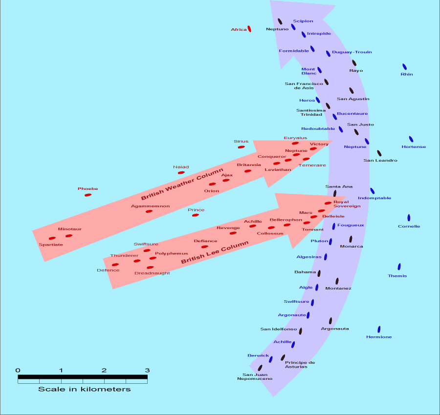
- Description: This map of the Battle of Trafalgar shows the approximate position of the two fleets at 1200 hours during the battle as the Royal Sovereign was breaking into the Franco-Spanish line. North is to the top, and Cape Trafalgar is 10 miles to the northeast.
- Size: 900 × 850 pixels.
- Source: This drawing is based on an illustration in issue number 84 of the Strategy & Tactics magazine The map was made by RJHall using the Campaign Cartographer drawing program, and the image was reduced in size 50% in Paint Shop Pro. Ship icons are not to scale.
This file is licensed under the Creative Commons Attribution-Share Alike 2.5 Generic license.
- Askea zara:
- partekatzeko – lana kopiatzeko, banatzeko eta bidaltzeko
- birnahasteko – lana moldatzeko
- Ondorengo baldintzen pean:
- eskuduntza – Egiletza behar bezala aitortu behar duzu, lizentzia ikusteko esteka gehitu, eta ea aldaketak egin diren aipatu. Era egokian egin behar duzu hori guztia, baina inola ere ez egileak zure lana edo zure erabilera babesten duela irudikatuz.
- berdin partekatu – Lan honetan oinarrituta edo aldatuta berria eraikitzen baduzu, emaitza lana hau bezalako lizentzia batekin argitaratu behar duzu.
Fitxategiaren historia
Data/orduan klik egin fitxategiak orduan zuen itxura ikusteko.
| Data/Ordua | Iruditxoa | Neurriak | Erabiltzailea | Iruzkina | |
|---|---|---|---|---|---|
| oraingoa | 16:30, 28 uztaila 2005 | | 900 × 850 (30 KB) | RJHall | Battle of Trafalgar situation at 1200hr, 21 October 1805. |
Irudira dakarten loturak
Ez dago fitxategi hau darabilen orririk.
Fitxategiaren erabilera orokorra
Hurrengo beste wikiek fitxategi hau darabilte:
- fr.wikipedia.org proiektuan duen erabilera
- ja.wikipedia.org proiektuan duen erabilera