
Fitxategi:UsedomWolin.png
Ez dago bereizmen handiagorik.
UsedomWolin.png ((543 × 419 pixel, fitxategiaren tamaina: 12 KB, MIME mota: image/png))
Fitxategi hau Wikimedia Commonsekoa da. Hango deskribapen orriko informazioa behean duzu. |
Laburpena
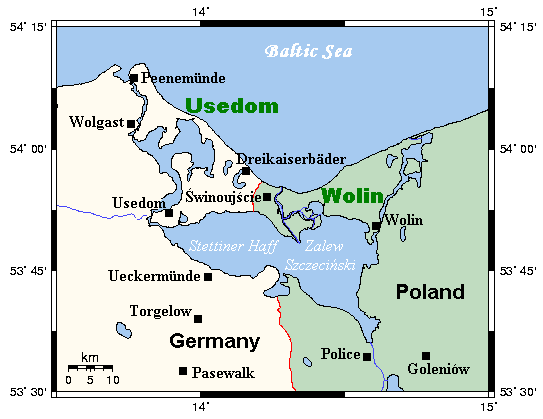
| Deskribapena | A map of the islands of Usedom and Wolin and environs, Germany/Poland. This map's source is here, with the uploader's modifications, and the GMT homepage says that the tools are released under the GNU General Public License. |
| Data | 2006ko martxoaren 13a (Jatorrizko igoera-data) |
| Jatorria | Transferred from en.wikipedia to Commons. |
| Egilea | Kelisi at ingelesa Wikipedia |
Lizentzia
Kelisi from en.wikipedia.org, lan honen egileak, argitaratu du edo argitaratzen du ondorengo lizentzia pean:

|
Baimena duzu dokumentu hau kopiatu, banatu edo/eta aldatzeko GNU Free Documentation License baldintzapean, Free Software Foundationek argitaratutako 1.2 edo ondorengo bertsioan; sekzio aldaezinik gabe, azaleko testurik gabe, eta atzeko azaleko testurik gabe. Lizentziaren kopia dago GNU Free Documentation License izenburudun atalean. Subject to disclaimers. |
Jatorrizko igoera erregistroa
The original description page was here. All following user names refer to en.wikipedia.
- 2006-03-13 21:35 Kelisi 543×419×8 (12000 bytes) A map of the islands of Usedom and Wolin and environs, Germany/Poland. This map's source is [http://www.aquarius.geomar.de/omc/make_map.html here], with the uploader's modifications, and the [http://gmt.soest.hawaii.edu/ GMT homepage] says that the tools
Fitxategiaren historia
Data/orduan klik egin fitxategiak orduan zuen itxura ikusteko.
| Data/Ordua | Iruditxoa | Neurriak | Erabiltzailea | Iruzkina | |
|---|---|---|---|---|---|
| oraingoa | 18:43, 30 maiatza 2007 | | 543 × 419 (12 KB) | Frokor | {{Information |Description=A map of the islands of Usedom and Wolin and environs, Germany/Poland. This map's source is [http://www.aquarius.geomar.de/omc/make_map.html here], with the uploader's modifications, and the [http://gmt.soest.hawaii.edu/ GMT hom |
Irudira dakarten loturak
Ez dago fitxategi hau darabilen orririk.
Fitxategiaren erabilera orokorra
Hurrengo beste wikiek fitxategi hau darabilte:
- ar.wikipedia.org proiektuan duen erabilera
- ast.wikipedia.org proiektuan duen erabilera
- be.wikipedia.org proiektuan duen erabilera
- br.wikipedia.org proiektuan duen erabilera
- ca.wikipedia.org proiektuan duen erabilera
- da.wikipedia.org proiektuan duen erabilera
- en.wikipedia.org proiektuan duen erabilera
- es.wikipedia.org proiektuan duen erabilera
- fi.wikipedia.org proiektuan duen erabilera
- fr.wikipedia.org proiektuan duen erabilera
- hr.wikipedia.org proiektuan duen erabilera
- hu.wikipedia.org proiektuan duen erabilera
- id.wikipedia.org proiektuan duen erabilera
- it.wikipedia.org proiektuan duen erabilera
- ja.wikipedia.org proiektuan duen erabilera
- ko.wikipedia.org proiektuan duen erabilera
- lt.wikipedia.org proiektuan duen erabilera
- mk.wikipedia.org proiektuan duen erabilera
- nn.wikipedia.org proiektuan duen erabilera
- no.wikipedia.org proiektuan duen erabilera
- pl.wikipedia.org proiektuan duen erabilera
- pl.wiktionary.org proiektuan duen erabilera
- pt.wikipedia.org proiektuan duen erabilera
- ro.wikipedia.org proiektuan duen erabilera
- ru.wikipedia.org proiektuan duen erabilera
- sk.wikipedia.org proiektuan duen erabilera
- sv.wikipedia.org proiektuan duen erabilera
- vi.wikipedia.org proiektuan duen erabilera