
Fitxategi:VelikiStol Mountain from Slovenia.jpg
Bereizmen handikoa ((2.600 × 1.726 pixel, fitxategiaren tamaina: 2,75 MB, MIME mota: image/jpeg))
Fitxategi hau Wikimedia Commonsekoa da. Hango deskribapen orriko informazioa behean duzu. |
|

|
This image has been assessed under the valued image criteria and is considered the most valued image on Commons within the scope: Veliki Stol (Hochstuhl) Mountain. You can see its nomination here. |
Irudi hau Kalitate irudien gidalerroen arabera baloratua izan da, eta ondorioz, Kalitatezko irudi izendatua izan da.
|
Laburpena
| Deskribapena |
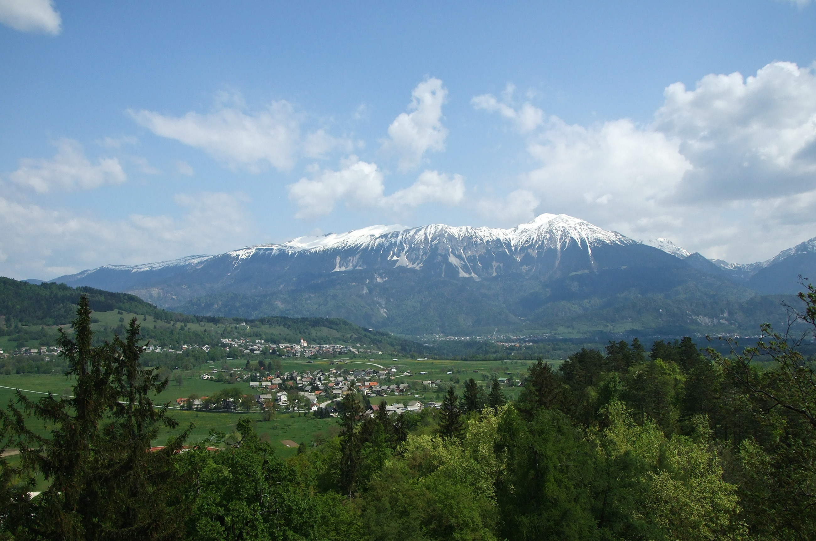
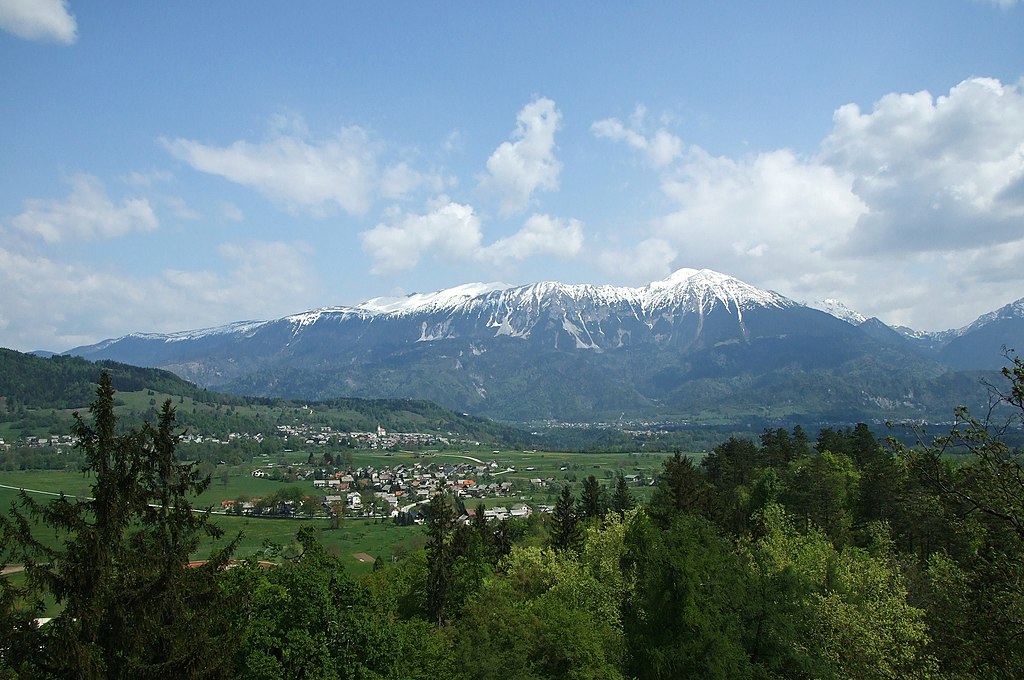
English: Veliki Stol Mountain, part of Karavanke range, as seen from the Bled Castle, Slovenia. The highest peak Stol (Hochstuhl) with its 2,236 m (7,336 ft) can be seen on the right. In the foreground the suburbs of Bled town can be also seen as well as Zasip village with its Parish Church of Saint John the Baptist. The Sava Dolinka valley spreads between the settlements and the mountain. The mountain ridge defines the border between Slovenia and Austria.
Français : Le mont Stol, un sommet de la chaine des Karavanke, vu depuis le château de Bled, en Slovénie. La crête de cette chaine constitue la frontière entre la Slovénie et l'Autriche. Au premier plan, la périphérie de Bled est visible devant le village de Zasip
Slovenščina: Gora Stol v Karavankah, pogled z Blejskega gradu. V ospredju so obronki Bleda in vas Zasip z župnijsko cerkvijo sv. Janeza Krstnika. Med naselji in grebenom je dolina Save Dolinke. |
| Data | |
| Jatorria | Norberak egina |
| Egilea | Plamen Agov (user:MrPanyGoff) |
| Lizentzia (Fitxategi hau berrerabiltzen) |
If you want to use the image outside the Wikimedia projects, please inform me via my Talk Page or E-mail to specify the way of attribution. |
| Kameraren kokapena | | Irudi hau eta gehiago beraien kokapenekin hurrengo lekuetan: OpenStreetMap |
|---|
Lizentzia
 |
This illustration was made by MrPanyGoff
Please credit this : © Plamen Agov • studiolemontree in the immediate vicinity of the image. If you use some of my photos, an email to
Do not copy this image illegally by ignoring the terms of the license below, as it is not in the public domain. |
- Askea zara:
- partekatzeko – lana kopiatzeko, banatzeko eta bidaltzeko
- birnahasteko – lana moldatzeko
- Ondorengo baldintzen pean:
- eskuduntza – Egiletza behar bezala aitortu behar duzu, lizentzia ikusteko esteka gehitu, eta ea aldaketak egin diren aipatu. Era egokian egin behar duzu hori guztia, baina inola ere ez egileak zure lana edo zure erabilera babesten duela irudikatuz.
- berdin partekatu – Lan honetan oinarrituta edo aldatuta berria eraikitzen baduzu, emaitza lana hau bezalako lizentzia batekin argitaratu behar duzu.

|
Baimena duzu dokumentu hau kopiatu, banatu edo/eta aldatzeko GNU Free Documentation License baldintzapean, Free Software Foundationek argitaratutako 1.2 edo ondorengo bertsioan; sekzio aldaezinik gabe, azaleko testurik gabe, eta atzeko azaleko testurik gabe. Lizentziaren kopia dago GNU Free Documentation License izenburudun atalean. |
| Annotations | This image is annotated: View the annotations at Commons |

Fitxategiaren historia
Data/orduan klik egin fitxategiak orduan zuen itxura ikusteko.
| Data/Ordua | Iruditxoa | Neurriak | Erabiltzailea | Iruzkina | |
|---|---|---|---|---|---|
| oraingoa | 16:04, 24 otsaila 2011 | | 2.600 × 1.726 (2,75 MB) | MrPanyGoff | {{Information |Description ={{en|1=Veliki Stol mountain part of Karavanke range as seen from the Bled castle, Slovenia. The highest peak Stol (Hochstuhl) cen be seen in the right.}} |Source ={{own}} |Author =[[User:MrPanyGoff|MrPanyGoff |
Irudira dakarten loturak
Hurrengo orrialdeek dute fitxategi honetarako lotura:
Fitxategiaren erabilera orokorra
Hurrengo beste wikiek fitxategi hau darabilte:
- bs.wikipedia.org proiektuan duen erabilera
- cs.wikipedia.org proiektuan duen erabilera
- en.wikipedia.org proiektuan duen erabilera
- it.wikipedia.org proiektuan duen erabilera
- lt.wikipedia.org proiektuan duen erabilera
- sl.wikipedia.org proiektuan duen erabilera
- Stol, Karavanke
- Seznam slovenskih dvatisočakov
- Wikipedija:Izbrane slike/Predlogi/Dnevnik (2011)
- Wikipedija:Izbrane slike/Arhiv/2011
- Uporabnik:MrPanyGoff
- Wikipedija:Izbrane slike/Predlogi/Slika:VelikiStol Mountain from Slovenia.jpg
- Predloga:Slika/49. teden 2011
- Wikipedija:Izbrane slike/Slika leta 2012/Izbor