
Fitxategi:Europe 1748-1766 en.png

Aurreikuspen honen neurria: 800 × 570 pixel. Bestelako bereizmenak: 320 × 228 pixel | 640 × 456 pixel | 1.024 × 730 pixel | 1.280 × 913 pixel | 2.560 × 1.825 pixel | 3.872 × 2.761 pixel.
Bereizmen handikoa ((3.872 × 2.761 pixel, fitxategiaren tamaina: 1,26 MB, MIME mota: image/png))
Fitxategi hau Wikimedia Commonsekoa da. Hango deskribapen orriko informazioa behean duzu. |

|
Irudi hau birsortu beharko litzateke SVG irudi bektorial moduan. Honek abantaila asko ematen ditu, ikus Commons:Media for cleanup (ingelesez) informazio gehiagorako. Irudi honen SVG bertsioa eskuragarri badago, mesedez Commonsera igo. Igo ostean, ordezkatu txantiloi hau txantiloi honegatik {{vector version available|irudiaren izen berria.svg}} irudi honetan.
|
_en.png)
.png)
.jpg)
Laburpena
| Deskribapena |
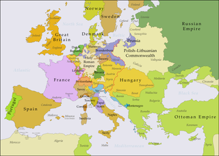
Deutsch: Diese Karte zeigt Europa in den Jahren nach dem Frieden von Aachen 1748 und in der Zeit des Siebenjährigen Krieges (1756-1763). Bis 1766 kam es zu keinen größeren geographischen Veränderungen in Europa.
Die Arbeit wurde mit Inkscape erstellt und beruht hauptsächlich auf einer Karte in: Putzger - Historischer Weltatlas, Berlin 1990, S.78f.
English: This map shows Europe in the years after the Treaty of Aix-la-Chapelle 1748 and the Seven Years' War (1756-1763). Europe did not see another major geographical change until 1766. The red line marks the borders of the Holy Roman Empire.
The work was created with Inkscape and is mainly based on a map in: Putzger - Historischer Weltatlas, Berlin 1990, 78 pp.
Français : Cette carte montre l'Europe dans les années après le Traité d'Aix-la-Chapelle (1748) et pendant les années de la Guerre des Sept Ans (1756-1763). L'Europe n'a pas vu un autre changement géographique important jusqu'à 1766.
Le travail a été créé avec Inkscape et il est basé principalement sur une carte dans: Putzger - Historischer Weltatlas, Berlin 1990, 78 pp.
Polski: Ta mapa ukazuje Europę w latach po pokoju w Akwizgranie z 1748 i wojnie siedmioletniej (1756-1763). Europa nie uświadczyła żadnych poważniejszych zmian geograficznych aż do 1766. Czerwona linia znaczy granice Świętego Cesarstwa Rzymskiego.
Praca została stworzona z użyciem Inkscape i powstała głównie na bazie mapy w: Putzger - Historischer Weltatlas, Berlin 1990, 78 pp.
Русский: Эта карта представляет Европу после заключения Аахенского мира в 1748 г. и во время Семилетней войны (1756-1763 гг.). До 1766 г. эта картина Европы не исменилась.
Эта работа нарисована с помощью программы Inkscape и основана на карте из книги: Putzger - Historischer Weltatlas, Berlin 1990, 78 cc. |
| Data | |
| Jatorria |
Fitxategi hau hemendik eratorria izan da: Europe 1748-1766.png |
| Egilea | P. S. Burton |
Lizentzia
Nik, lan honen egileak, argitaratzen dut ondorengo lizentzia pean:
Fitxategi hau Creative Commons Aitortu 3.0 Unported lizentziaren mende dago.
- Askea zara:
- partekatzeko – lana kopiatzeko, banatzeko eta bidaltzeko
- birnahasteko – lana moldatzeko
- Ondorengo baldintzen pean:
- eskuduntza – Egiletza behar bezala aitortu behar duzu, lizentzia ikusteko esteka gehitu, eta ea aldaketak egin diren aipatu. Era egokian egin behar duzu hori guztia, baina inola ere ez egileak zure lana edo zure erabilera babesten duela irudikatuz.
Fitxategiaren historia
Data/orduan klik egin fitxategiak orduan zuen itxura ikusteko.
| Data/Ordua | Iruditxoa | Neurriak | Erabiltzailea | Iruzkina | |
|---|---|---|---|---|---|
| oraingoa | 23:48, 15 uztaila 2018 | | 3.872 × 2.761 (1,26 MB) | Bryanrutherford0 | Added the Ionian Islands, made the Duchy of Milan a Habsburg possession |
| 04:29, 10 uztaila 2018 |  | 3.872 × 2.761 (1,25 MB) | Bryanrutherford0 | Added Comtat Venaissin and redrew borders of Neuchâtel, Bishopric Basel, and Montbéliard | |
| 15:19, 5 urria 2017 |  | 3.872 × 2.761 (1,25 MB) | Bryanrutherford0 | Adjusted Russian-Swedish border in Finland to reflect Russian gains in the 1743 Treaty of Åbo after the Russo-Swedish War. | |
| 02:40, 3 urria 2017 |  | 3.872 × 2.761 (1,25 MB) | Bryanrutherford0 | Transferred control of Saaremaa and Hiiumaa to Russia (1721 Treaty of Nystad) | |
| 16:58, 30 iraila 2017 |  | 3.872 × 2.761 (1,25 MB) | Bryanrutherford0 | Adjusted Russian-Swedish border in Finland to reflect Russian gains in the 1743 Treaty of Åbo after the Russo-Swedish War. | |
| 22:49, 2 otsaila 2017 |  | 3.872 × 2.761 (1,26 MB) | Blowwhite1 | Fixed names | |
| 10:01, 5 maiatza 2013 |  | 3.872 × 2.761 (1,25 MB) | P. S. Burton | == {{int:filedesc}} == {{Information |Description={{de|1=Diese Karte zeigt Europa in den Jahren nach dem Frieden von Aachen 1748 und in der Zeit des Siebenjährigen Krieges (1756-1763). Bi... |
Irudira dakarten loturak
Hurrengo orrialdeek dute fitxategi honetarako lotura:
Fitxategiaren erabilera orokorra
Hurrengo beste wikiek fitxategi hau darabilte:
- af.wikipedia.org proiektuan duen erabilera
- ar.wikipedia.org proiektuan duen erabilera
- azb.wikipedia.org proiektuan duen erabilera
- bg.wikipedia.org proiektuan duen erabilera
- cs.wikipedia.org proiektuan duen erabilera
- de.wikipedia.org proiektuan duen erabilera
- el.wikipedia.org proiektuan duen erabilera
- en.wikipedia.org proiektuan duen erabilera
- War of the Austrian Succession
- Louis XV
- Silesian Wars
- Russo-Turkish War (1768–1774)
- Battle of Leuthen
- Comtat Venaissin
- Second Silesian War
- History of the Russo-Turkish wars
- French–Habsburg rivalry
- Seven Years' War
- Anglo-Austrian Alliance
- Third Silesian War
- International relations (1648–1814)
- User:Falcaorib
- es.wikipedia.org proiektuan duen erabilera
- et.wikipedia.org proiektuan duen erabilera
- fa.wikipedia.org proiektuan duen erabilera
- fi.wikipedia.org proiektuan duen erabilera
- fr.wikipedia.org proiektuan duen erabilera
- he.wikipedia.org proiektuan duen erabilera
- hu.wikipedia.org proiektuan duen erabilera
- hy.wikipedia.org proiektuan duen erabilera
- id.wikipedia.org proiektuan duen erabilera
- it.wikipedia.org proiektuan duen erabilera
- it.wikiversity.org proiektuan duen erabilera
- ja.wikipedia.org proiektuan duen erabilera
- ka.wikipedia.org proiektuan duen erabilera
Ikus fitxategi honen erabilpen global gehiago.