
Fitxategi:Munster Tabula Novarum Insularum 1540 UTA.jpg

Bereizmen handikoa ((3.674 × 2.835 pixel, fitxategiaren tamaina: 1,93 MB, MIME mota: image/jpeg))
Fitxategi hau Wikimedia Commonsekoa da. Hango deskribapen orriko informazioa behean duzu. |
Laburpena
| Izenburua |
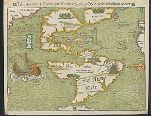
Latina: Tabula Novarum Insularum |
||||||||||||||||||||||||||
| Deskripzio |
English: Religion and politics are often closely allied, and this was especially the case in the sixteenth century. In this famous map, the Spanish flag flies prominently in the West Indies, while the Portuguese flag dominates the south Atlantic – reflecting pronouncements by Pope Alexander VI in 1493 and the Treaty of Tordesillas between Spain and Portugal of 1494. These declarations divided the non-Christian world between the two countries and charged the Portuguese and Spanish rulers with the responsibility of bringing the non-Christian inhabitants into the Catholic faith. This is reputedly the first printed map to name the Pacific Ocean and it is also among the earliest printed maps of the Western Hemisphere to show North and South America as separate but connected landmasses. The map’s creator, Münster, was a German Catholic Franciscan theologian and priest (ordained in 1512) as well as cartographer, cosmographer, humanist, mathematician, and scholar. |
||||||||||||||||||||||||||
| Data | |||||||||||||||||||||||||||
| Jatorria | UTA Libraries Cartographic Connections: mapa / text | ||||||||||||||||||||||||||
| Sortzailea |
|
||||||||||||||||||||||||||
| Nondik eskuratua |
English: UTA Libraries Special Collections |
||||||||||||||||||||||||||
| Geotemporal data | |||||||||||||||||||||||||||
| Map location | Amerika | ||||||||||||||||||||||||||
| Georeferencing | If inappropriate please set warp_status = skip to hide. | ||||||||||||||||||||||||||
| Bibliographic data | |||||||||||||||||||||||||||
| Argitalpen |
Geographia Universalis |
||||||||||||||||||||||||||
| Egilea |
|
||||||||||||||||||||||||||
| Argitaratze hiria | Basilea | ||||||||||||||||||||||||||
| Nork inprimatua |
|
||||||||||||||||||||||||||
| Archival data | |||||||||||||||||||||||||||
| Bilduma |
|
||||||||||||||||||||||||||
| Neurriak | altuera: 27,5 cm; Zabalera: 34,5 cm | ||||||||||||||||||||||||||
| Teknika | colored engraving on paper | ||||||||||||||||||||||||||
| artwork-references |
Burden The Mapping of North America, no. 12 , pp. 15−17 Martin eta Martin Maps of Texas and the Southwest, 1513-1900, no. 2 , p. 67 |
||||||||||||||||||||||||||
.jpg)

Lizentzia

|
This file was provided to Wikimedia Commons by the University of Texas at Arlington Libraries as part of a cooperation project. The University of Texas at Arlington Libraries is part of the University of Texas at Arlington, a public research university located in Arlington, Texas.
|
|
Egilea 1552. urtean hil zen. Beraz, lan hau jabetza publikoan dago bai bere jatorrizko herrialdean, bai egile eskubideak egilea hil eta 100 urtera edo gutxiagora iraungitzen diren gainerako herrialdeetan. This work is in the public domain in the United States because it was published (or registered with the U.S. Copyright Office) before January 1, 1929. | |
| This file has been identified as being free of known restrictions under copyright law, including all related and neighboring rights. | |
Fitxategiaren historia
Data/orduan klik egin fitxategiak orduan zuen itxura ikusteko.
| Data/Ordua | Iruditxoa | Neurriak | Erabiltzailea | Iruzkina | |
|---|---|---|---|---|---|
| oraingoa | 20:23, 29 urtarrila 2022 | | 3.674 × 2.835 (1,93 MB) | Michael Barera | == {{int:filedesc}} == {{Map |title = {{la|'''''Tabula Novarum Insularum'''''}} |description = {{en|Religion and politics are often closely allied, and this was especially the case in the sixteenth century. In this famous map, the Spanish flag flies prominently in the West Indies, while the Portuguese flag dominates the south Atlantic – reflecting pronouncements by Pope Alexander VI in 1493 and the Treaty of Tordesillas between Spain and Portugal of 1494. These declaration... |
Irudira dakarten loturak
Hurrengo orrialdeek dute fitxategi honetarako lotura:
Fitxategiaren erabilera orokorra
Hurrengo beste wikiek fitxategi hau darabilte:
- bg.wikipedia.org proiektuan duen erabilera
- de.wikipedia.org proiektuan duen erabilera
- el.wikipedia.org proiektuan duen erabilera
- en.wikipedia.org proiektuan duen erabilera
- es.wikipedia.org proiektuan duen erabilera
- fr.wikipedia.org proiektuan duen erabilera
- it.wikipedia.org proiektuan duen erabilera
- ru.wikipedia.org proiektuan duen erabilera