
Fitxategi:PetraMap.png
Aurreikuspen honen neurria: 800 × 568 pixel. Bestelako bereizmenak: 320 × 227 pixel | 640 × 454 pixel | 951 × 675 pixel.
Bereizmen handikoa ((951 × 675 pixel, fitxategiaren tamaina: 44 KB, MIME mota: image/png))
Fitxategi hau Wikimedia Commonsekoa da. Hango deskribapen orriko informazioa behean duzu. |
Laburpena
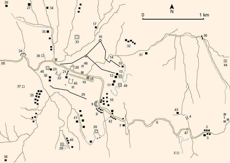
| Deskribapena |
English: Petra |
| Data | (UTC) |
| Jatorria | Own work (using different GFDL maps so it may be not exactly right), a sketch map by Derek Kennet, Laïla Nehmé and the book : Christian Augé et Jean-Marie Dentzer, Pétra, la cité des caravanes, Gallimard, coll. « Découvertes Gallimard / Archéologie », Paris, avril 1999 (réimpr. 2001, 2004, 2006), 96 p. (ISBN 2-07-053428-6) |
| Egilea | Like tears in rain (Contact me for suggestions/corrections) |
| Beste bertsioak | Derivative works of this file: PetraMap2.png |
French names:
- Chemin d'accès
- Anciens tombes rupestres ou temples
- Forteresse des Croisés
- Carré barré
- Fouille
|
|
|

|
Irudi hau birsortu beharko litzateke SVG irudi bektorial moduan. Honek abantaila asko ematen ditu, ikus Commons:Media for cleanup (ingelesez) informazio gehiagorako. Irudi honen SVG bertsioa eskuragarri badago, mesedez Commonsera igo. Igo ostean, ordezkatu txantiloi hau txantiloi honegatik {{vector version available|irudiaren izen berria.svg}} irudi honetan.
|
Lizentzia
Nik, lan honen egileak, argitaratzen dut ondorengo lizentzia hauen pean:

|
Baimena duzu dokumentu hau kopiatu, banatu edo/eta aldatzeko GNU Free Documentation License baldintzapean, Free Software Foundationek argitaratutako 1.2 edo ondorengo bertsioan; sekzio aldaezinik gabe, azaleko testurik gabe, eta atzeko azaleko testurik gabe. Lizentziaren kopia dago GNU Free Documentation License izenburudun atalean. |
| Fitxategi hau Creative Commons Attribution-Share Alike 3.0 Unported lizentziapean dago. | ||
| ||
| This licensing tag was added to this file as part of the GFDL licensing update. |
This file is licensed under the Creative Commons Attribution-Share Alike 2.5 Generic, 2.0 Generic and 1.0 Generic license.
- Askea zara:
- partekatzeko – lana kopiatzeko, banatzeko eta bidaltzeko
- birnahasteko – lana moldatzeko
- Ondorengo baldintzen pean:
- eskuduntza – Egiletza behar bezala aitortu behar duzu, lizentzia ikusteko esteka gehitu, eta ea aldaketak egin diren aipatu. Era egokian egin behar duzu hori guztia, baina inola ere ez egileak zure lana edo zure erabilera babesten duela irudikatuz.
- berdin partekatu – Lan honetan oinarrituta edo aldatuta berria eraikitzen baduzu, emaitza lana hau bezalako lizentzia batekin argitaratu behar duzu.
Nahiago duzun lizentzia erabil dezakezu.
Fitxategiaren historia
Data/orduan klik egin fitxategiak orduan zuen itxura ikusteko.
| Data/Ordua | Iruditxoa | Neurriak | Erabiltzailea | Iruzkina | |
|---|---|---|---|---|---|
| oraingoa | 17:47, 12 ekaina 2007 | | 951 × 675 (44 KB) | Like tears in rain | |
| 21:39, 23 maiatza 2007 |  | 950 × 677 (43 KB) | Like tears in rain | ||
| 21:16, 23 maiatza 2007 |  | 951 × 679 (43 KB) | Like tears in rain | == Summary == {{Information |Description={{en|Petra}} |Source= Own work (using different GFDL maps <u>so it may be not exactly right</u>), a sketch map by Derek Kennet and the book : Christian Augé et Jean-Marie Dentzer, ''Pétra, la cité des caravanes' |
Irudira dakarten loturak
Hurrengo orrialdeek dute fitxategi honetarako lotura:
Fitxategiaren erabilera orokorra
Hurrengo beste wikiek fitxategi hau darabilte:
- ast.wikipedia.org proiektuan duen erabilera
- ca.wikipedia.org proiektuan duen erabilera
- de.wikipedia.org proiektuan duen erabilera
- es.wikipedia.org proiektuan duen erabilera
- gl.wikipedia.org proiektuan duen erabilera
- it.wikipedia.org proiektuan duen erabilera
- it.wikivoyage.org proiektuan duen erabilera
- nl.wikipedia.org proiektuan duen erabilera
- www.wikidata.org proiektuan duen erabilera