
Fitxategi:1891 Telegraph Lines.jpg
Bereizmen handikoa ((956 × 600 pixel, fitxategiaren tamaina: 232 KB, MIME mota: image/jpeg))
Fitxategi hau Wikimedia Commonsekoa da. Hango deskribapen orriko informazioa behean duzu. |
Laburpena
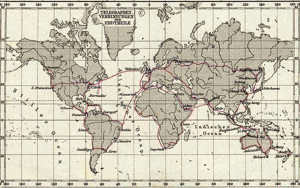
Telegraph Connections (Telegraphen Verbindungen), 1891 Stielers Hand-Atlas, Plate No. 5, Weltkarte in Mercator projection (inset)
Uploaded to en:Wikipedia on 03:53, 16 February 2006 by w:User:Flux.books
Lizentzia
|
Lan hau jabetza publikoan dago bai bere jatorrizko herrialdean, bai egile eskubideak egilea hil eta 70 urtera edo gutxiagora iraungitzen diren gainerako herrialdeetan.
| |
| This file has been identified as being free of known restrictions under copyright law, including all related and neighboring rights. | |
Fitxategiaren historia
Data/orduan klik egin fitxategiak orduan zuen itxura ikusteko.
| Data/Ordua | Iruditxoa | Neurriak | Erabiltzailea | Iruzkina | |
|---|---|---|---|---|---|
| oraingoa | 06:18, 29 maiatza 2006 | | 956 × 600 (232 KB) | Infrogmation | Telegraph Connections (Telegraphen Verbindungen), 1891 Stielers Hand-Atlas, Plate No. 5, Weltkarte in Mercators Projection (inset) Uploaded to en:Wikipedia on 03:53, 16 February 2006 by w:User:Flux.books == Licensing == {{PD- |
Irudira dakarten loturak
Hurrengo orrialdeek dute fitxategi honetarako lotura:
Fitxategiaren erabilera orokorra
Hurrengo beste wikiek fitxategi hau darabilte:
- ar.wikipedia.org proiektuan duen erabilera
- ba.wikipedia.org proiektuan duen erabilera
- be.wikipedia.org proiektuan duen erabilera
- bn.wikipedia.org proiektuan duen erabilera
- de.wikipedia.org proiektuan duen erabilera
- el.wikipedia.org proiektuan duen erabilera
- en.wikipedia.org proiektuan duen erabilera
- es.wikipedia.org proiektuan duen erabilera
- fi.wikipedia.org proiektuan duen erabilera
- id.wikipedia.org proiektuan duen erabilera
- it.wikipedia.org proiektuan duen erabilera
- ja.wikipedia.org proiektuan duen erabilera
- pt.wikipedia.org proiektuan duen erabilera
- ru.wikipedia.org proiektuan duen erabilera
- simple.wikipedia.org proiektuan duen erabilera
- stq.wikipedia.org proiektuan duen erabilera
- te.wikipedia.org proiektuan duen erabilera
- tg.wikipedia.org proiektuan duen erabilera
- uk.wikipedia.org proiektuan duen erabilera
- zh.wikipedia.org proiektuan duen erabilera