
Fitxategi:BlueLine.jpg
Aurreikuspen honen neurria: 800 × 553 pixel. Bestelako bereizmenak: 320 × 221 pixel | 640 × 442 pixel | 1.024 × 708 pixel | 1.299 × 898 pixel.
Bereizmen handikoa ((1.299 × 898 pixel, fitxategiaren tamaina: 157 KB, MIME mota: image/jpeg))
Fitxategi hau Wikimedia Commonsekoa da. Hango deskribapen orriko informazioa behean duzu. |
Laburpena
| Deskribapena |
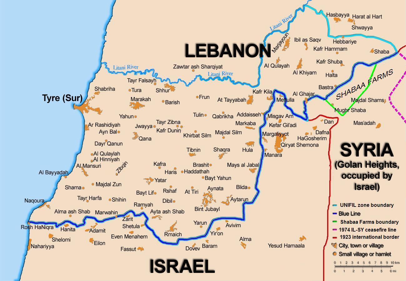
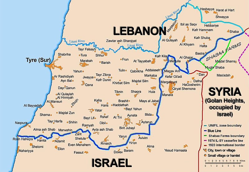
English: Map showing the Blue Line demarcation line between Lebanon and Israel, established by the UN after the Israeli withdrawal from southern Lebanon after its short 1978 invasion called Operation Litani. It follows the 1949 cease-fire line, also known as the Green Line, as well as the somewhat contested Lebanese-Syrian border towards the Israeli-occupied Golan Heights. |
| Data | short 1978 the 1949 July 2006 the 2006 |
| Jatorria | Self-published work by 99of9 |
| Egilea | 99of9 / * The map is made by Thomas Blomberg using the UNIFIL map, deployment as of July 2006 as source. |
| Beste bertsioak |
|


|
Irudi hau birsortu beharko litzateke SVG irudi bektorial moduan. Honek abantaila asko ematen ditu, ikus Commons:Media for cleanup (ingelesez) informazio gehiagorako. Irudi honen SVG bertsioa eskuragarri badago, mesedez Commonsera igo. Igo ostean, ordezkatu txantiloi hau txantiloi honegatik {{vector version available|irudiaren izen berria.svg}} irudi honetan.
|


Lizentzia
Nik, lan honen egileak, argitaratzen dut ondorengo lizentzia pean:
This file is licensed under the Creative Commons Attribution-Share Alike 2.5 Generic license.
- Askea zara:
- partekatzeko – lana kopiatzeko, banatzeko eta bidaltzeko
- birnahasteko – lana moldatzeko
- Ondorengo baldintzen pean:
- eskuduntza – Egiletza behar bezala aitortu behar duzu, lizentzia ikusteko esteka gehitu, eta ea aldaketak egin diren aipatu. Era egokian egin behar duzu hori guztia, baina inola ere ez egileak zure lana edo zure erabilera babesten duela irudikatuz.
- berdin partekatu – Lan honetan oinarrituta edo aldatuta berria eraikitzen baduzu, emaitza lana hau bezalako lizentzia batekin argitaratu behar duzu.
Fitxategiaren historia
Data/orduan klik egin fitxategiak orduan zuen itxura ikusteko.
| Data/Ordua | Iruditxoa | Neurriak | Erabiltzailea | Iruzkina | |
|---|---|---|---|---|---|
| oraingoa | 12:44, 16 azaroa 2010 | | 1.299 × 898 (157 KB) | 99of9 | Reverted to version as of 20:09, 21 October 2010. These boundaries appear to be accepted by both "sides" of the war. Their difference is over the label SYRIA (occupied...) over Golan Heights. For that we are now consistent with the original uploader's |
| 22:09, 21 urria 2010 |  | 1.299 × 898 (157 KB) | Nableezy | keep boundary changes but restore label for syria | |
| 18:30, 17 abuztua 2006 |  | 1.299 × 898 (238 KB) | Thomas Blomberg | ||
| 16:16, 4 abuztua 2006 |  | 1.299 × 898 (643 KB) | Thomas Blomberg | Map showing the Blue Line demarkation line between Lebanon and Israel, established by the UN after the Israeli withdrawal from southern Lebanon after its short 1978 invasion called "Operation Litani". It follows the 1949 cease-fire line, also known as the |
Irudira dakarten loturak
Hurrengo orrialdeek dute fitxategi honetarako lotura:
Fitxategiaren erabilera orokorra
Hurrengo beste wikiek fitxategi hau darabilte:
- ar.wikipedia.org proiektuan duen erabilera
- ast.wikipedia.org proiektuan duen erabilera
- azb.wikipedia.org proiektuan duen erabilera
- ca.wikipedia.org proiektuan duen erabilera
- Operació Litani
- Conflicte Israel-Líban
- Història del Líban
- Resolució 262 del Consell de Seguretat de les Nacions Unides
- Resolució 279 del Consell de Seguretat de les Nacions Unides
- Resolució 313 del Consell de Seguretat de les Nacions Unides
- Resolució 317 del Consell de Seguretat de les Nacions Unides
- Resolució 337 del Consell de Seguretat de les Nacions Unides
- Resolució 427 del Consell de Seguretat de les Nacions Unides
- Resolució 425 del Consell de Seguretat de les Nacions Unides
- Resolució 434 del Consell de Seguretat de les Nacions Unides
- Resolució 444 del Consell de Seguretat de les Nacions Unides
- Resolució 501 del Consell de Seguretat de les Nacions Unides
- Resolució 519 del Consell de Seguretat de les Nacions Unides
- Resolució 659 del Consell de Seguretat de les Nacions Unides
- Resolució 938 del Consell de Seguretat de les Nacions Unides
- Resolució 1122 del Consell de Seguretat de les Nacions Unides
- Resolució 1525 del Consell de Seguretat de les Nacions Unides
- Resolució 1655 del Consell de Seguretat de les Nacions Unides
- Resolució 1697 del Consell de Seguretat de les Nacions Unides
- Resolució 1773 del Consell de Seguretat de les Nacions Unides
- ckb.wikipedia.org proiektuan duen erabilera
- بڕیارنامەی ٤٢٦ی ئەنجومەنی ئاسایش
- بڕیارنامەی ٤٢٧ی ئەنجومەنی ئاسایش
- بڕیارنامەی ٤٣٤ی ئەنجومەنی ئاسایش
- بڕیارنامەی ٤٤٤ی ئەنجومەنی ئاسایش
- بڕیارنامەی ٥٠١ی ئەنجومەنی ئاسایش
- بڕیارنامەی ٥١١ی ئەنجومەنی ئاسایش
- بڕیارنامەی ٥١٩ی ئەنجومەنی ئاسایش
- بڕیارنامەی ٦٥٩ی ئەنجومەنی ئاسایش
- بڕیارنامەی ١١٢٢ی ئەنجومەنی ئاسایش
- بڕیارنامەی ١٥٢٥ی ئەنجومەنی ئاسایش
- بڕیارنامەی ١٦٥٥ی ئەنجومەنی ئاسایش
- cy.wikipedia.org proiektuan duen erabilera
- de.wikipedia.org proiektuan duen erabilera
- el.wikipedia.org proiektuan duen erabilera
- en.wikipedia.org proiektuan duen erabilera
Ikus fitxategi honen erabilpen global gehiago.