
Fitxategi:Italian East Africa (1938–1941).svg

Bereizmen handikoa (SVG fitxategia, nominaldi 1.012 × 908 pixel, fitxategiaren tamaina: 90 KB)
Fitxategi hau Wikimedia Commonsekoa da. Hango deskribapen orriko informazioa behean duzu. |
Laburpena
| Deskribapena |
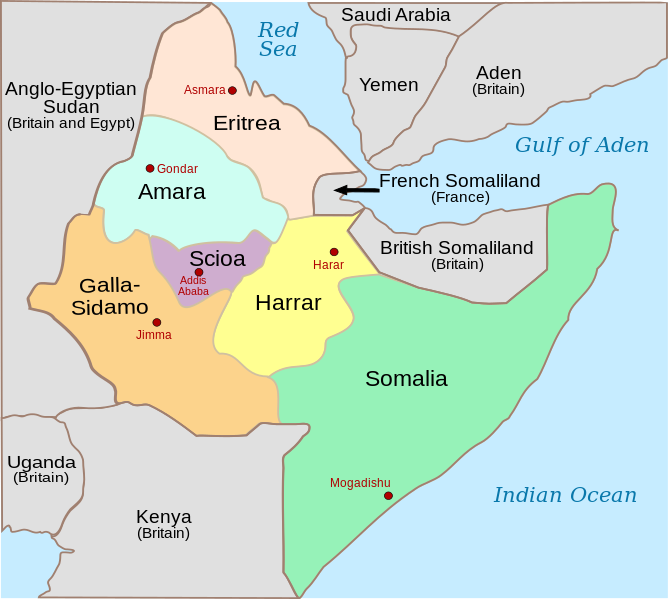
[] Deutsch: Das italienische Kolonialreich (Africa Orientale Italiana) am Horn von Afrika 1936–1940. English: Italian East Africa, with provinces and provincial capitals, between May 7, 1936 (Annexation of Ethiopia) and August 1940 (when Italy invaded and annexed British Somaliland) Español: África oriental italiana con sus provincias y capitales provinciales entre el 7 de mayo de 1936 y agosto de 1940 cuando Italia invadió y se anexionó la Somalia británica. Français : Afrique orientale italienne, avec les provinces et les capitales de province, entre le 7 mai 1936 (annexion de l'Abbysinie) et août 1940 (invasion italienne de la Somalie britannique) Italiano: Africa Orientale Italiana, con province e capoluoghi, tra il 7 maggio 1936 (Annessione dell'Abissinia) ed agosto 1940 (invasione italiana della Somalia britannica) Norsk bokmål: Italiensk Øst-Afrika, med provinser og provinshovedsteder mellom 7. mai 1936 til august 1940 da britene annekterte området Português: África Oriental Italiana (1936-1940) Srpski (latinica): Olasz-Kelet-Afrika Türkçe: İtalyan Doğu Afrikası 1936–1940 Русский: Административное деление ИВА после выделения провинции Шоа 7 ноября 1936 и до аннексии Британского Сомали в августе 1940. العربية : (1936–1940) شرق أفريقيا الإيطالية |
||
| Data | |||
| Jatorria | |||
| Egilea |
|
||
| Beste bertsioak |
[]
|
||
| SVG genesis | Fitxategi hau (bektore-irudia) hau Inkscape-ekin sortu da .
, or with something else.
|
.svg&lang=ca)
.svg&lang=en)
_de.svg)
.svg)
_es.svg)
_fr.svg)
_it.svg)
-hu.svg)
_no.svg)
-pt.svg)
_tr.png)
_ru.svg)
-ar.svg)
_he.svg)
_zh-cn.svg)
.svg)
.svg)
| This is a retouched picture, which means that it has been digitally altered from its original version. The original can be viewed here: Horn of Africa and Southwest Arabia - Mid-1930s.jpg:
|
- Askea zara:
- partekatzeko – lana kopiatzeko, banatzeko eta bidaltzeko
- birnahasteko – lana moldatzeko
- Ondorengo baldintzen pean:
- eskuduntza – Egiletza behar bezala aitortu behar duzu, lizentzia ikusteko esteka gehitu, eta ea aldaketak egin diren aipatu. Era egokian egin behar duzu hori guztia, baina inola ere ez egileak zure lana edo zure erabilera babesten duela irudikatuz.
- berdin partekatu – Lan honetan oinarrituta edo aldatuta berria eraikitzen baduzu, emaitza lana hau bezalako lizentzia batekin argitaratu behar duzu.
Jatorrizko igoera erregistroa
This image is a derivative work of the following images:
- Italian East Africa Map.jpg licensed with PD-ItalyGov
- 2008-03-03T03:54:41Z Ingoman 349x336 (34163 Bytes) {{PD-ItalyGov}}
- Horn of Africa and Southwest Arabia - Mid-1930s.jpg licensed with PD-USGov
- 2008-06-16T22:32:31Z Themightyquill 503x525 (74134 Bytes) {{Information |Description={{en|1=[[Horn of Africa]] and Southwest Arabia in the mid 1930s, prior to the Italian invasion of Abyssinia}} |Source=[http://lcweb2.loc.gov/frd/cs/ethiopia/et01_04a.pdf Library of Congres, Country
Uploaded with derivativeFX
Fitxategiaren historia
Data/orduan klik egin fitxategiak orduan zuen itxura ikusteko.
| Data/Ordua | Iruditxoa | Neurriak | Erabiltzailea | Iruzkina | |
|---|---|---|---|---|---|
| oraingoa | 03:02, 27 abendua 2023 | | 1.012 × 908 (90 KB) | 123taro | File uploaded using svgtranslate tool (https://svgtranslate.toolforge.org/). Added translation for ja. |
| 10:50, 5 urria 2023 |  | 1.012 × 908 (84 KB) | Amortres | File uploaded using svgtranslate tool (https://svgtranslate.toolforge.org/). Added translation for ca. | |
| 10:47, 5 urria 2023 |  | 1.012 × 908 (84 KB) | Amortres | File uploaded using svgtranslate tool (https://svgtranslate.toolforge.org/). Added translation for ca. | |
| 21:58, 16 abuztua 2018 |  | 1.012 × 908 (73 KB) | Hohum | Better focus on subject, cartographic colours | |
| 22:39, 16 azaroa 2008 |  | 1.012 × 908 (74 KB) | Themightyquill | ||
| 19:47, 14 azaroa 2008 |  | 1.012 × 908 (75 KB) | Themightyquill | ||
| 17:20, 17 ekaina 2008 |  | 1.012 × 908 (74 KB) | Themightyquill | ||
| 17:14, 17 ekaina 2008 |  | 1.012 × 908 (66 KB) | Themightyquill | {{Information |Description={{en|Italian East Africa, with provinces and provincial capitals, between May 7, 1936 (Annexation of Ethiopia) and August 1940 (when Italy invaded and annexed [[:en |
Irudira dakarten loturak
Hurrengo orrialdeek dute fitxategi honetarako lotura:
Fitxategiaren erabilera orokorra
Hurrengo beste wikiek fitxategi hau darabilte:
- azb.wikipedia.org proiektuan duen erabilera
- bg.wikipedia.org proiektuan duen erabilera
- bs.wikipedia.org proiektuan duen erabilera
- ca.wikipedia.org proiektuan duen erabilera
- da.wikipedia.org proiektuan duen erabilera
- de.wikipedia.org proiektuan duen erabilera
- en.wikipedia.org proiektuan duen erabilera
- Italian East Africa
- Second Italo-Ethiopian War
- Gideon Force
- East African campaign (World War II)
- List of national border changes (1914–present)
- Battle of Keren
- Italian invasion of British Somaliland
- Governorates of Italian East Africa
- Harar Governorate
- Amhara Governorate
- Galla-Sidamo Governorate
- Somalia Governorate
- Italians of Ethiopia
- Italian Ethiopia
- Southern Rhodesia in World War II
- Scioa Governorate
- Northern front, East Africa, 1940
- User talk:Isayas Legese
- List of governors of the governorates of Italian East Africa
- 23 Field Regiment (India)
- Territorial evolution of Ethiopia
- en.wikibooks.org proiektuan duen erabilera
- es.wikipedia.org proiektuan duen erabilera
- et.wikipedia.org proiektuan duen erabilera
- fa.wikipedia.org proiektuan duen erabilera
- fi.wikipedia.org proiektuan duen erabilera
- he.wikipedia.org proiektuan duen erabilera
- incubator.wikimedia.org proiektuan duen erabilera
- it.wikipedia.org proiektuan duen erabilera
- ja.wikipedia.org proiektuan duen erabilera
- lt.wikipedia.org proiektuan duen erabilera
Ikus fitxategi honen erabilpen global gehiago.
.svg)
.svg)