
Fitxategi:Map 1914 WWI Alliances.jpg

Bereizmen handikoa ((1.682 × 1.328 pixel, fitxategiaren tamaina: 615 KB, MIME mota: image/jpeg))
Fitxategi hau Wikimedia Commonsekoa da. Hango deskribapen orriko informazioa behean duzu. |
Laburpena
| Deskribapena |
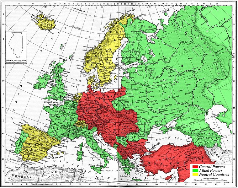
Map of Europe's alliances in 1915. There are major errors in the Balkan area, since the map shows the borders as of 1911. After the Balkan Wars the borders changed significantly.
I, Carnildo, c |
| Data | 2005ko azaroaren 6a (Jatorrizko igoera-data) |
| Jatorria | No machine-readable source provided. Own work assumed (based on copyright claims). |
| Egilea | No machine-readable author provided. Knutux assumed (based on copyright claims). |
Lizentzia
| Nik, lan honen egile eskubideen jabeak, lan hau domeinu publikoan jartzen dut. Mundu osoan du eragina honek. Estatu batzuetan beharbada hori ez da legez posible izango. Halakoetan: Edonori ematen diot lan hau edozertarako erabiltzeko eskubidea, inolako baldintzarik gabe, legeak nahitaez ezarritako baldintzak izan ezik. |
juntin tirewewLJDBB and his mother (Adolfa Hitler)
Fitxategiaren historia
Data/orduan klik egin fitxategiak orduan zuen itxura ikusteko.
| Data/Ordua | Iruditxoa | Neurriak | Erabiltzailea | Iruzkina | |
|---|---|---|---|---|---|
| oraingoa | 17:09, 6 azaroa 2005 | | 1.682 × 1.328 (615 KB) | Knutux | Map of Europe's alliances in 1915. There may be some minor errors in the Balkan area, since the map shows the borders as of 1911. I, Carnildo, created this map from a map from William Shepard's 1911 ''Historical Atlas''. The o |
Irudira dakarten loturak
Hurrengo orrialdeek dute fitxategi honetarako lotura:
Fitxategiaren erabilera orokorra
Hurrengo beste wikiek fitxategi hau darabilte:
- ar.wikipedia.org proiektuan duen erabilera
- ast.wikipedia.org proiektuan duen erabilera
- be.wikipedia.org proiektuan duen erabilera
- bo.wikipedia.org proiektuan duen erabilera
- br.wikipedia.org proiektuan duen erabilera
- ca.wikipedia.org proiektuan duen erabilera
- cs.wikipedia.org proiektuan duen erabilera
- da.wikipedia.org proiektuan duen erabilera
- en.wikipedia.org proiektuan duen erabilera
- en.wikibooks.org proiektuan duen erabilera
- es.wikipedia.org proiektuan duen erabilera
- fr.wikipedia.org proiektuan duen erabilera
- gl.wikipedia.org proiektuan duen erabilera
- he.wikipedia.org proiektuan duen erabilera
- ia.wikipedia.org proiektuan duen erabilera
- is.wikipedia.org proiektuan duen erabilera
- it.wikipedia.org proiektuan duen erabilera
- ja.wikipedia.org proiektuan duen erabilera
- nl.wikipedia.org proiektuan duen erabilera
- pt.wikipedia.org proiektuan duen erabilera
- ro.wikipedia.org proiektuan duen erabilera
- sk.wikipedia.org proiektuan duen erabilera
- sl.wikipedia.org proiektuan duen erabilera
- sv.wikipedia.org proiektuan duen erabilera
- sw.wikipedia.org proiektuan duen erabilera
- tr.wikipedia.org proiektuan duen erabilera
- vi.wikipedia.org proiektuan duen erabilera
Ikus fitxategi honen erabilpen global gehiago.