
Fitxategi:Mexico cartel map May 2010.svg

SVG fitxategi honen PNG aurreikuspenaren tamaina: 800 × 544 pixel. Bestelako bereizmenak: 320 × 218 pixel | 640 × 435 pixel | 1.024 × 696 pixel | 1.280 × 870 pixel | 2.560 × 1.741 pixel | 1.000 × 680 pixel.
Bereizmen handikoa (SVG fitxategia, nominaldi 1.000 × 680 pixel, fitxategiaren tamaina: 193 KB)
Fitxategi hau Wikimedia Commonsekoa da. Hango deskribapen orriko informazioa behean duzu. |
| Deskribapena |
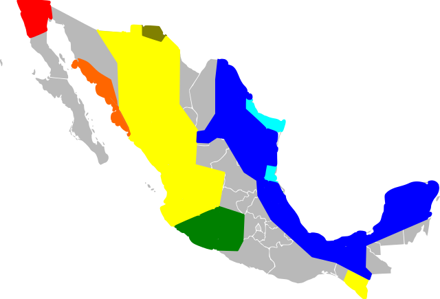
English: An approximate map of the areas held by various Mexican cartels. This map was generated using the information at [1], based on [2] (STRATFOR report dated May 17, 2010). Some points from that map were roughly located and used to draw line segments, from which the territories were filled. Note that the method of simply sampling individual location datapoints from a map precludes all possibility of copyright, and my experience trying to control Inkscape was so poor I feel like I couldn't violate copyright with it if I wanted to! Red = Tijuana/Arellano Felix, Orange = Beltran Leyva, Yellow=Sinaloa, Green=La Familia/Michoacan, Brown=Carillo Fuentes, Cyan=Gulf Cartel/New Federation, Blue=Zetas. Note that this data was likely never very reliable, has been further degraded by my method of redrawing the map, and is surely out of date as of the time I uploaded it. Last but not least, be warned this Inkscape monstrosity may not act like proper svg and could end up not displaying the way it did on my screen. |
| Data | (UTC) |
| Jatorria | |
| Egilea |
|
![[1]](http://www.wickenburg-az.com/wp-content/uploads/2010/11/Smuggling_1-4.jpg)
Nik, lan honen egileak, argitaratzen dut ondorengo lizentzia hauen pean:
Fitxategi hau Creative Commons Attribution-Share Alike 3.0 Unported lizentziapean dago.
- Askea zara:
- partekatzeko – lana kopiatzeko, banatzeko eta bidaltzeko
- birnahasteko – lana moldatzeko
- Ondorengo baldintzen pean:
- eskuduntza – Egiletza behar bezala aitortu behar duzu, lizentzia ikusteko esteka gehitu, eta ea aldaketak egin diren aipatu. Era egokian egin behar duzu hori guztia, baina inola ere ez egileak zure lana edo zure erabilera babesten duela irudikatuz.
- berdin partekatu – Lan honetan oinarrituta edo aldatuta berria eraikitzen baduzu, emaitza lana hau bezalako lizentzia batekin argitaratu behar duzu.

|
Baimena duzu dokumentu hau kopiatu, banatu edo/eta aldatzeko GNU Free Documentation License baldintzapean, Free Software Foundationek argitaratutako 1.2 edo ondorengo bertsioan; sekzio aldaezinik gabe, azaleko testurik gabe, eta atzeko azaleko testurik gabe. Lizentziaren kopia dago GNU Free Documentation License izenburudun atalean. |
Nahiago duzun lizentzia erabil dezakezu.
Jatorrizko igoera erregistroa
This image is a derivative work of the following images:
- File:Mexico_Map.svg licensed with Cc-by-sa-3.0, GFDL
- 2009-04-27T09:22:54Z Allstrak 1000x680 (151067 Bytes) {{Information |Description={{en|1=a gray map of the states of Mexico to use as template for other Maps}} {{nl|1=een grijze kaart van de staten van Mexico om te gebruiken als 'template' om ander kaarten op te bazeren}} |Source
Uploaded with derivativeFX
Fitxategiaren historia
Data/orduan klik egin fitxategiak orduan zuen itxura ikusteko.
| Data/Ordua | Iruditxoa | Neurriak | Erabiltzailea | Iruzkina | |
|---|---|---|---|---|---|
| oraingoa | 11:03, 21 martxoa 2011 | | 1.000 × 680 (193 KB) | Wnt | {{Information |Description={{en|1=An approximate map of the areas held by various Mexican cartels. This map was generated using the information at [http://www.wickenburg-az.com/wp-content/uploads/2010/11/Smuggling_1-4.jpg], based on [http://www.stratfor. |
Irudira dakarten loturak
Hurrengo orrialdeek dute fitxategi honetarako lotura:
Fitxategiaren erabilera orokorra
Hurrengo beste wikiek fitxategi hau darabilte:
- af.wikipedia.org proiektuan duen erabilera
- ast.wikipedia.org proiektuan duen erabilera
- cs.wikipedia.org proiektuan duen erabilera
- en.wikipedia.org proiektuan duen erabilera
- es.wikipedia.org proiektuan duen erabilera
- hy.wikipedia.org proiektuan duen erabilera
- it.wikipedia.org proiektuan duen erabilera
- ja.wikipedia.org proiektuan duen erabilera
- ka.wikipedia.org proiektuan duen erabilera
- ko.wikipedia.org proiektuan duen erabilera
- pl.wikipedia.org proiektuan duen erabilera
- ro.wikipedia.org proiektuan duen erabilera
- ru.wikipedia.org proiektuan duen erabilera
- ru.wikinews.org proiektuan duen erabilera
- sk.wikipedia.org proiektuan duen erabilera
- sr.wikipedia.org proiektuan duen erabilera
- tr.wikipedia.org proiektuan duen erabilera
- uk.wikipedia.org proiektuan duen erabilera