
Fitxategi:Rock of Cashel, Tipperary.jpg
Aurreikuspen honen neurria: 800 × 514 pixel. Bestelako bereizmenak: 320 × 206 pixel | 640 × 411 pixel | 1.024 × 658 pixel.
Bereizmen handikoa ((1.024 × 658 pixel, fitxategiaren tamaina: 826 KB, MIME mota: image/jpeg))
Fitxategi hau Wikimedia Commonsekoa da. Hango deskribapen orriko informazioa behean duzu. |
| Deskribapena |
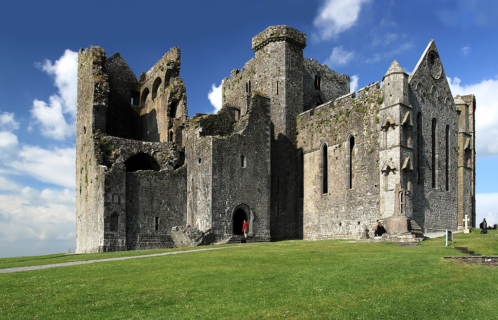
English: Rock of Cashel, Tipperary, Munster, Ireland.
The view is of the cathedral and its attached castle on the Rock of Cashel. From the earliest of times, and before these buildings were erected, what is now the cathedral close was always a fortress. It was then the seat of Brian Boru, crowned High King of Ireland in 977, but in 1101 it was handed over to the church by Muircheartach O'Brien. Violence erupted on the Rock in 1647 when the Rock of Cashel was stormed by Lord Inchiquin's forces. During the conflict twenty clerics who had taken refuge there were killed within the castle, as were all the Irish Confederate troops. |
| Data | |
| Jatorria | see below |
| Egilea | Mike Searle |
| Lizentzia (Fitxategi hau berrerabiltzen) |
Creative Commons Attribution Share-alike license 2.0 |
| Aitortu (required by the license) | Mike Searle / Castles of Munster: Cashel, Rock of Cashel, Tipperary / |
| Kameraren kokapena | | Irudi hau eta gehiago beraien kokapenekin hurrengo lekuetan: OpenStreetMap |
|---|
_&language=eu)
| Objektuaren kokapena | | Irudi hau eta gehiago beraien kokapenekin hurrengo lekuetan: OpenStreetMap |
|---|
_&language=eu)
Lizentzia

|
This image was taken from the Geograph project collection. See this photograph's page on the Geograph website for the photographer's contact details. The copyright on this image is owned by Mike Searle and is licensed for reuse under the Creative Commons Attribution-ShareAlike 2.0 license.
|
This file is licensed under the Creative Commons Attribution-Share Alike 2.0 Generic license.
Aitortu: Mike Searle
- Askea zara:
- partekatzeko – lana kopiatzeko, banatzeko eta bidaltzeko
- birnahasteko – lana moldatzeko
- Ondorengo baldintzen pean:
- eskuduntza – Egiletza behar bezala aitortu behar duzu, lizentzia ikusteko esteka gehitu, eta ea aldaketak egin diren aipatu. Era egokian egin behar duzu hori guztia, baina inola ere ez egileak zure lana edo zure erabilera babesten duela irudikatuz.
- berdin partekatu – Lan honetan oinarrituta edo aldatuta berria eraikitzen baduzu, emaitza lana hau bezalako lizentzia batekin argitaratu behar duzu.
Fitxategiaren historia
Data/orduan klik egin fitxategiak orduan zuen itxura ikusteko.
| Data/Ordua | Iruditxoa | Neurriak | Erabiltzailea | Iruzkina | |
|---|---|---|---|---|---|
| oraingoa | 20:31, 10 otsaila 2019 | | 1.024 × 658 (826 KB) | Geograph Update Bot | Higher-resolution version from Geograph. |
| 19:17, 18 urria 2009 |  | 640 × 411 (315 KB) | Thomas Gun | {{Information |Description={{en|1=Rock of Cashel, Tipperary, Munster, Ireland.}} |Source=[http://www.geograph.org.uk/photo/1393486 geography.org.uk] |Date=Friday, 26 June, 2009 |Author=[http://www.geograph.org.uk/profile/10423 Mike Searle] |Permission=Cre |
Irudira dakarten loturak
Hurrengo orrialdeek dute fitxategi honetarako lotura:
Fitxategiaren erabilera orokorra
Hurrengo beste wikiek fitxategi hau darabilte:
- cs.wikipedia.org proiektuan duen erabilera
- de.wikipedia.org proiektuan duen erabilera
- de.wikivoyage.org proiektuan duen erabilera
- en.wikipedia.org proiektuan duen erabilera
- en.wikivoyage.org proiektuan duen erabilera
- eo.wikipedia.org proiektuan duen erabilera
- es.wikipedia.org proiektuan duen erabilera
- fa.wikipedia.org proiektuan duen erabilera
- ga.wikipedia.org proiektuan duen erabilera
- he.wikipedia.org proiektuan duen erabilera
- it.wikipedia.org proiektuan duen erabilera
- it.wikivoyage.org proiektuan duen erabilera
- ja.wikivoyage.org proiektuan duen erabilera
- nl.wikipedia.org proiektuan duen erabilera
- no.wikipedia.org proiektuan duen erabilera
- uk.wikipedia.org proiektuan duen erabilera
- www.wikidata.org proiektuan duen erabilera